


Get to know Congjiang County
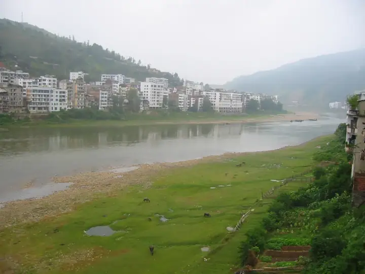
Photo adjustments
Full frame retained; resized proportionally to a maximum dimension of 960 pixels and converted to WebP quality 88. No crop, retouch, generated elements, or subject alteration. Final website rendition: full frame retained, proportionally resized to at most 720 pixels and converted to WebP. No additional retouching or subject alteration. Card displays may crop the view.
- Administrative area
- County · 县
- Part of
- Qiandongnan Miao and Dong Autonomous Prefecture
- Chinese name
- 从江县
- Local areas
- County guide
Area & population
- Area in the source
- 3,244.00 km²
- Population · 2010
- 290,845
- Administrative seat
- Bingmei
Source: cited geographic source, as of the dates shown.
Setting and landscape
Congjiang borders Sanjiang Dong Autonomous County (三江侗族自治县) in Guangxi to the east, Rongshui (融水苗族自治县) and Huanjiang (环江毛南族自治县) in Guangxi to the south, Libo (荔波县) and Rongjiang (榕江县) to the west, and Liping (黎平县) to the north. The land climbs away on both sides of the Duliu River, which crosses the county from north to south for 66 kilometres and belongs to the Pearl River system; mountains cover more than 91 per cent of the county. The county seat is 250 kilometres from the prefecture seat at Kaili (凯里) and 290 kilometres from Guiyang (贵阳).
History
Yongcong County (永从县) was created in 1441 from two Ming native chieftaincies, and the Qing set up Xiajiang subprefecture (下江厅) in 1771, which became Xiajiang County in 1913. In 1941 the two counties were merged and the new county took one character from each name, Cong from Yongcong and Jiang from Xiajiang. Congjiang was folded into Rongjiang County in December 1958 and restored in August 1961.
What to see
Basha Miao village (岜沙苗寨), 7.5 kilometres from the county town, is made up of five hamlets at 480 to 660 metres. Basha men shave the sides of the head and tie the hair on top into a knot called "hugun" (户棍), and carry a waist knife; the villagers venerate a tree god and a sun god. A pavilion built in 1977 marks the camphor trees the village gave for the Mao Zedong Memorial Hall in Beijing, and a clearing of about 700 square metres in old woodland serves as the lusheng (芦笙) ground.
Xiaohuang Dong village (小黄侗寨) was named a home of Dong grand song (侗族大歌) by the Guizhou culture department in 1994; its main sights are the drum tower, the wind-and-rain bridges, the rice-drying racks and the Chuange stream (传歌河), named after 24 young people who were keen singers of Dong songs. Zengchong (增冲) in Wangdong township (往洞乡), 91 kilometres from the county town, is a Dong village more than 600 years old with three covered bridges over the Zengchong River and nearly 40 courtyard houses behind fire walls. At the Jiabang terraces (加榜梯田), rice terraces and Miao villages share the slopes.
Food and local products
The Dong rice–fish–duck farming system of Congjiang is designated by the Food and Agriculture Organization as a Globally Important Agricultural Heritage System. In spring, glutinous rice is soaked in water boiled with the flowers of mimeng (密蒙花), locally called huangcaohua (黄草花), and steamed into yellow rice, which is also made into cakes.
Highlights
- Basha Miao Village 岜沙苗寨: Five hamlets 7.5 km from the county town; men wear the hugun topknot.
- Xiaohuang Dong Village 小黄侗寨: Named a home of Dong grand song by the Guizhou culture department in 1994.
- Zengchong 增冲: Dong village over 600 years old with three covered bridges.
- Jiabang Rice Terraces 加榜梯田: Terraced fields with Miao villages.
Sources for this guide
走进从江-从江县人民政府 · Congjiang County People's Government
从江县特色景点 · Congjiang County People's Government
舌尖上的从江,特色小吃来了 · Congjiang County People's Government
从江县 - 维基百科,自由的百科全书 · Wikipedia (Chinese) · CC BY-SA 4.0
Original English written from the listed sources and checked sentence by sentence against quoted extracts by a separate reviewer. Updated 2026-09-25.
Explore Congjiang County
Core places to explore, with English and Chinese names.
Places to explore around Congjiang County
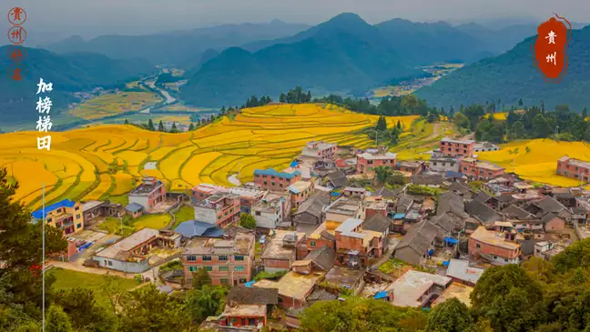 Jiabang Rice Terraces · 加榜梯田
Jiabang Rice Terraces加榜梯田
The Jiabang terraces follow the folds of steep hills around villages such as Dangniu, Jiaye and Jiache. Curving field edges form the main pattern, with timber stilt houses appearing between the cultivated slopes. Flooded fields…
Read the place guide → Xiaohuang Dong Village · 小黄侗寨
Xiaohuang Dong Village小黄侗寨
Xiaohuang is a Dong village in Gaozeng township, Congjiang County, Qiandongnan, Guizhou, with more than 700 households and over 3,000 people. It is described by China's National Ethnic Affairs Commission as the birthplace of Dong Grand Song, and it received a national cultural designation from the Ministry of Culture in 1996.
Read the place guide →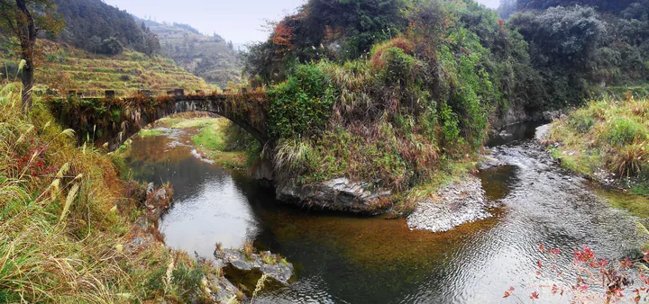 A stone arch bridge with a grassy parapet crossing a shallow rocky stream, terraced fields rising on the hillside behind it, autumn grasses and shrubs along the banks and scattered village buildings on the upper slope under a pale sky.
Basha Miao Village岜沙苗寨
Basha is a Miao village whose old trees and stone paths are central to its physical setting. Timber houses sit among the wooded slopes, while local clothing and hairstyles are visible elements of a living cultural tradition…
Read the place guide →Plan your visit
Getting there
Congjiang County is about 130 km in a straight line from central Qiandongnan Miao and Dong Autonomous Prefecture. Search for 从江县 in a map app to find stations and your accommodation.
Where to stay →Build your route
Jiabang Rice Terraces and Xiaohuang Dong Village are both listed here. The linked place guides have entrance and visit details.
Continue with Qiandongnan Miao and Dong Autonomous Prefecture →More in Qiandongnan Miao and Dong Autonomous Prefecture
Sources & geographic information
Administrative names and parent areas: Official geographic directory · Reference date 2026-09-06.
Some facts checked against 从江县 — Wikipedia contributors, CC BY-SA 4.0.
Photo: Jiabang Rice Terraces · Source photographer · License not provided. EXIF orientation normalized; resized without changing aspect ratio; converted to WebP. No subject edits.
Photo: Xiaohuang Dong Village · Source photographer · License not provided. EXIF orientation normalized; resized without changing aspect ratio; converted to WebP. No subject edits.
Photo: Basha Miao Village · 龙歌谷 · CC BY-SA 3.0. Full frame retained; proportionally resized and converted to WebP. No retouching or changes to the photographed subject. Card displays may crop the view.

Map data © OpenStreetMap contributors. Pins mark approximate centres, not entrances or boundaries.