


Get to know Qianxi County

Photo adjustments
Full frame retained; proportionally resized and converted to WebP. No retouching or changes to the photographed subject. Card displays may crop the view.
- Administrative area
- County · 县
- Part of
- Tangshan
- Chinese name
- 迁西县
- Local areas
- County guide
Area & population
- Area in the source
- 1,439.00 km²
- Population · 2020 census
- 365,615
Source: cited geographic source, as of the dates shown.
Setting and landscape
Qianxi sits at the southern foot of the Yan Mountains (燕山). It has ten main rivers, including the Luan and the Chang River (长河), and 84 reservoirs, among them Panjiakou (潘家口) and Daheiting (大黑汀). The county government also claims rocks here dated to 3.67 billion years. It is 150 kilometres east of Beijing and 75 kilometres from Tangshan city.
History
Neolithic finds at Xizhai (西寨) and nearby sites show settlement five to six thousand years ago. The county itself is young: it was split from the western part of Qian'an County (迁安县) in 1946, hence the name "West of Qian", and formally set up in April 1947. It was abolished in 1958 and restored in 1961.
In the Ming, Santunying (三屯营), 13 kilometres northwest of the county seat, was the headquarters of the Jizhen (蓟镇) frontier command; Qi Jiguang (戚继光) rebuilt the walled town in 1574–1577 and guarded this frontier for 16 years. During the war against Japan, the generals Song Zheyuan (宋哲元) and Zhang Zizhong (张自忠) fought Japanese troops at Xifengkou (喜峰口), a stand that made the "Big Sword March" (大刀进行曲) famous across China.
What to see
The county holds 106 kilometres of Ming Great Wall, with 203 watchtowers and ten passes. The Qingshanguan (青山关) and Xifengkou sections are on the first national list of key Great Wall sites. Qingshanguan is a 4A scenic area in Qingshankou village (青山口村), Tangshan's northernmost village, 50 kilometres from the county seat. The county describes its lifting water gate as the best preserved on the Great Wall, and the site includes a walled Great Wall fort.
Panjiakou Reservoir, on the border with Chengde's Kuancheng (宽城) and Xinglong (兴隆) counties, is the main work of the scheme that carries Luan water to Tianjin; it reaches 80 metres deep, and part of the Great Wall near Xifengkou now lies under water. Jingzhong Mountain (景忠山), a 4A scenic area, holds a Qing imperial temple listed as a provincial protected site; 1,872 stone steps climb to the summit, and the Kangxi Emperor inscribed it "a famous mountain under heaven" (天下名山).
Food and local products
Liule huoshao (刘乐火勺), a Tangshan municipal heritage item from Santunying, is a small baked flatbread said to descend from field rations for Qi Jiguang's soldiers. Naturally fermented dough has a special ingredient, youshu (油酥, literally "oil crisp"), kneaded into it and is baked on iron plates in an oven until golden, layered and crisp.
Highlights
- Qingshanguan 青山关: 4A Great Wall pass with a lifting water gate and fort, in Tangshan's northernmost village.
- Panjiakou Reservoir 潘家口水库: Main reservoir of the Luan-to-Tianjin water scheme, with a submerged stretch of Great Wall.
- Jingzhong Mountain 景忠山: 4A scenic area with a Qing imperial temple and 1,872 stone steps to the top.
- Santunying 三屯营: Ming headquarters of the Jizhen frontier command, rebuilt by Qi Jiguang in 1574–1577.
- Liule huoshao 刘乐火勺: Layered, crisp baked flatbread from Santunying on the Tangshan municipal heritage list.
Sources for this guide
迁西概况 - 迁西县人民政府 · Qianxi County People's Government
历史沿革 - 迁西县人民政府 · Qianxi County People's Government
景忠山 - 迁西县人民政府 · Qianxi County Bureau of Culture, Radio, Television and Tourism
青山关 - 迁西县人民政府 · Qianxi County People's Government
潘家口水库 - 迁西县人民政府 · Qianxi County People's Government
刘乐火勺(传统技艺) - 迁西县人民政府 · Qianxi County People's Government
Original English written from the listed sources and checked sentence by sentence against quoted extracts by a separate reviewer. Updated 2026-09-24.
Explore Qianxi County
Core places to explore, with English and Chinese names.
Places to explore around Qianxi County
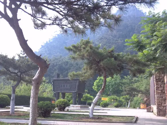 Jingzhong Mountain · 景忠山
Jingzhong Mountain景忠山
Jingzhong Mountain (景忠山) is a 610-metre mountain in Qianxi where Buddhist temples, Daoist halls and shrines to historical figures share a pine-covered hillside.
Read the place guide → AI illustration · AI 示意图(仅供参考,非该地点实拍)
Qingshanguan Pass青山关
Qingshanguan is a Great Wall pass and fortified settlement in Qianxi County, set among the hills north of Tangshan.
Read the place guide →Plan your visit
Getting there
Qianxi County is about 60 km in a straight line from central Tangshan. Search for 迁西县 in a map app to find stations and your accommodation.
Where to stay →Build your route
Jingzhong Mountain and Qingshanguan Pass are both listed here. The linked place guides have entrance and visit details.
Continue with Tangshan →More in Tangshan
Sources & geographic information
Administrative names and parent areas: Official geographic directory · Reference date 2026-09-06.
Photo: Jingzhong Mountain · Source photographer · License not provided. EXIF orientation normalized; resized without changing aspect ratio; converted to WebP. No subject edits.
Map data © OpenStreetMap contributors. Pins mark approximate centres, not entrances or boundaries.