


Get to know Yutian County
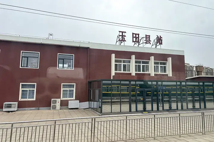
Photo adjustments
EXIF orientation normalized; resized without changing aspect ratio; converted to WebP. No subject edits.
- Administrative area
- County · 县
- Part of
- Tangshan
- Chinese name
- 玉田县
- Local areas
- County guide
Area & population
- Area in the source
- 1,169.00 km²
- Population · 2012
- 690,000
- Administrative seat
- Yutian Town (玉田镇)
Source: cited geographic source, as of the dates shown.
Setting and landscape
The county has hills in the north, low-lying ground in the south and a fertile plain in the middle; the plain makes up 45.2 per cent of its area and is the main grain-growing land. Yutian has long been known as the "granary of eastern Hebei" (冀东粮仓). Its main rivers are the Jiyun (蓟运河), Huanxiang (还乡河), Lanquan (兰泉河) and Shuangcheng (双城河). The Beijing–Qinhuangdao and Datong–Qinhuangdao railways, National Highway 102 and the G1 Beijing–Harbin Expressway all cross the county.
History
In the Spring and Autumn period this was the state of Wuzhong (无终国), and under the Qin and Han it belonged to Youbeiping Commandery (右北平郡). In 696, under Wu Zetian, the county took the name Yutian, "jade field", from a tale in the In Search of the Supernatural (搜神记) collection in which Yang Boyong (阳伯雍) planted stones on Mount Ma (麻山) and harvested jade.
People from Yutian include the Qing physician Wang Qingren (王清任), author of Correcting the Errors in the Forest of Medicine (医林改错), the palaeoanthropologist Jia Lanpo (贾兰坡), a discoverer of Peking Man skull fossils, and the actor Jiang Wen (姜文).
What to see
Jingjue Temple (净觉寺), beside the Huanxiang River, is on the sixth list of national key protected sites and is a 3A scenic area. Its inscriptions trace the temple to the Tang, but the present buildings are mostly Qing: five courtyards facing south over 20,000 square metres. The gate hall is a beamless brick-and-stone hall, two coiled-dragon stone columns stand before the rear hall, and the bell and drum towers resemble the corner towers of Beijing's Forbidden City. The county government calls it the best-preserved old temple complex in Tangshan.
In Caitingqiao town (彩亭桥镇), 15 li west of the county seat, the Caiting Bridge (彩亭桥石桥) is a three-arch stone bridge 19 metres long, dated to the Jin dynasty and named after Caiting, the literary name of Yang Hui (杨绘), a scholar who served the Jin. Small carved lions, lotus petals and peaches top its balusters. It became a provincial protected site in 2001, and the county government describes it as the only Jin stone arch bridge left in Hebei.
Food and local products
Yutian's farm specialities are known as the "four big and one small": Chinese cabbage, scallions, garlic and big radishes, plus small golden-silk jujubes (金丝小枣).
Highlights
- Jingjue Temple 净觉寺: Qing-era temple of Tang origin with a beamless gate hall; national key protected site.
- Caiting Bridge 彩亭桥石桥: Three-arch Jin-dynasty stone bridge with lion-topped balusters; provincial protected site since 2001.
- Golden-silk jujubes 金丝小枣: The "one small" among Yutian's five signature farm products.
Sources for this guide
玉田简介--唐山市玉田县人民政府 · Yutian County People's Government
净觉寺--唐山市玉田县人民政府 · Yutian County People's Government
彩亭桥石桥--唐山市玉田县人民政府 · Yutian County People's Government
Original English written from the listed sources and checked sentence by sentence against quoted extracts by a separate reviewer. Updated 2026-09-24.
Explore Yutian County
Core places to explore, with English and Chinese names.
Yutian County 玉田县
Plan your visit
Getting there
Yutian County is about 50 km in a straight line from central Tangshan. Search for 玉田县 in a map app to find stations and your accommodation.
Where to stay →More in Tangshan
Sources & geographic information
Administrative names and parent areas: Official geographic directory · Reference date 2026-09-06.
Map data © OpenStreetMap contributors. Pins mark approximate centres, not entrances or boundaries.