


Get to know Zunhua
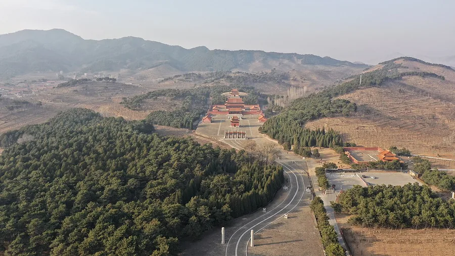
Photo adjustments
Proportionally resized and converted to WebP without cropping, retouching or changing the photographed subject.
- Administrative area
- County-level city · 县级市
- Part of
- Tangshan
- Chinese name
- 遵化市
- Local areas
- County-level city guide
Area & population
- Area in the source
- 1,521.00 km²
- Population · 2020
- 707,047
Source: cited geographic source, as of the dates shown.
Setting and landscape
Three ranges of hills and two river plains run across the city from north to south. Beijing lies 158 kilometres to the west, Tangshan 75 kilometres to the south and Chengde (承德) 100 kilometres to the north. Shuipingkou Wetland Park (水平口湿地公园) in Baozidian town (堡子店镇), the city's only wetland park, takes in water from Chengde and Qianxi (迁西) and connects downstream with the Yuqiao Reservoir (于桥水库); egrets breed along its wooded banks.
History
In the Spring and Autumn period the area was the state of Wuzhong (无终国). Zunhua County was created under the Later Tang (923–936) on the site of a Tang horse-buying station; the Zunhua County Gazetteer (遵化县志) reads the name as following the teaching of Confucius and Mencius to civilise the people. The building of the Eastern Qing Tombs raised it to a zhou (州) in 1676, and in 1743 it became a directly administered zhou governing Yutian (玉田) and Fengrun (丰润). It became a county-level city in 1992.
Two villages won national fame. In the 1950s Mao Zedong praised the "paupers' spirit" of Xipu (西铺村), and in the 1960s Zhou Enlai called the people of Shashiyu (沙石峪), who carried a thousand loads for each mu of field and raised high yields on bare rock, "modern Yugong".
What to see
The Eastern Qing Tombs, 125 kilometres northeast of Beijing and part of the UNESCO World Heritage Site of the Imperial Tombs of the Ming and Qing Dynasties, spread over 80 square kilometres ringed by mountains. The Shunzhi (顺治), Kangxi (康熙), Qianlong (乾隆), Xianfeng (咸丰) and Tongzhi (同治) emperors lie here with 15 empresses and 136 consorts. Shunzhi's Xiaoling (孝陵) sits at the centre and set the pattern for the rest. Qianlong's Yuling (裕陵) has nine vaults behind four marble doors, covered with Buddhist imagery and more than 30,000 words of Tibetan and Sanskrit scripture. Cixi's Ding Dongling (定东陵) has halls of valuable red wood decorated with gold-glazed paintings and gilded dragons; her tomb and Qianlong's were looted by Sun Dianying's (孙殿英) troops in 1928.
Bijia Mountain (笔架山), 6 kilometres from the urban area, takes its name from peaks shaped like a brush rest. A stele of 1899 records a Bixia Yuanjun (碧霞元君) palace, a Jade Emperor hall and a Dizang (地藏) hall on its three main peaks.
Food and local products
Zunhua carries national titles as a home of hot springs, chestnuts and shiitake mushrooms, and as a centre for the craft of palace-style furniture.
Highlights
- Eastern Qing Tombs 清东陵: Burial ground of five Qing emperors, 15 empresses and 136 consorts over 80 square kilometres.
- Yuling 裕陵: Qianlong's tomb, with nine vaults and scripture carved in Tibetan and Sanskrit.
- Bijia Mountain 笔架山: Brush-rest-shaped peaks 6 kilometres from the city, with temple halls recorded on an 1899 stele.
- Shuipingkou Wetland Park 水平口湿地公园: The city's only wetland park, where egrets breed.
Sources for this guide
遵化市市情简介 - 遵化市人民政府 · Zunhua Municipal People's Government
遵化简史 - 遵化市人民政府 · Zunhua Municipal People's Government
打卡遵化水平口!碧水栖白鹭,湿地藏清欢 - 遵化市人民政府 · Zunhua Municipal People's Government
赴一场笔架山的雾之约 - 遵化市人民政府 · Zunhua Municipal People's Government
Eastern Qing tombs - Wikipedia · English Wikipedia · CC BY-SA 4.0
Original English written from the listed sources and checked sentence by sentence against quoted extracts by a separate reviewer. Updated 2026-09-24.
Explore Zunhua
Core places to explore, with English and Chinese names.
Places to explore around Zunhua
Plan your visit
Getting there
Zunhua is about 65 km in a straight line from central Tangshan. Search for 遵化市 in a map app to find stations and your accommodation.
Where to stay →Build your route
Start with Eastern Qing tombs. The linked place guides have entrance and visit details.
Continue with Tangshan →More in Tangshan
Sources & geographic information
Administrative names and parent areas: Official geographic directory · Reference date 2026-09-06.
Some facts checked against Eastern Qing tombs — Wikipedia contributors, CC BY-SA 4.0.
Photo: Eastern Qing tombs · Charlie fong · CC BY-SA 4.0. Proportionally resized and converted to WebP without cropping, retouching or changing the photographed subject.

Map data © OpenStreetMap contributors. Pins mark approximate centres, not entrances or boundaries.