


Get to know Daqingshan County
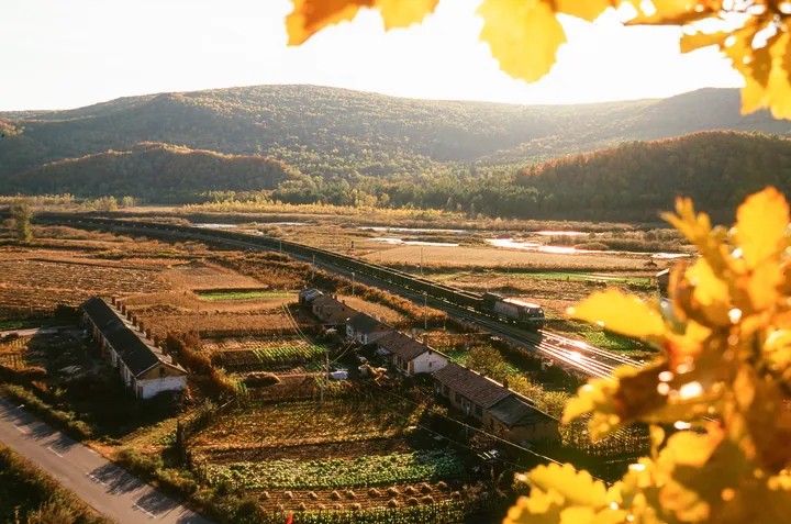
Photo adjustments
Full frame retained; proportionally resized and converted to WebP. No retouching or changes to the photographed subject. Card displays may crop the view.
- Administrative area
- County · 县
- Part of
- Yichun
- Chinese name
- 大箐山县
- Local areas
- County guide
Area & population
- Area in the source
- 1,041.00 km²
- Population · 2014
- 35,522
- Administrative seat
- Dailing Subdistrict (带岭街道)
Source: cited geographic source, as of the dates shown.
History
The county grew out of the timber industry. Its predecessor, Dailing District (带岭区), was opened up in 1937 and set up as a forestry bureau in 1946; from 1952 it came directly under the central Ministry of Forestry, and from 1964 the same body ran both the government and the forestry enterprise. In 2019 Dailing District was abolished and Daqingshan County created in its place, taking in Langxiang town (朗乡镇) from Tieli (铁力). Two forestry companies of the Yichun Forest Industry Group, at Langxiang and Dailing, still operate in the county. In June 2020 it was named in the second list of counties within revolutionary-heritage protection zones.
Setting and landscape
Winters are long, dry and cold under Siberian air, and summers short and wet under the Pacific monsoon. The mean annual temperature is about 1.4°C, January lows can reach −40°C, and the frost-free season lasts only about 115 days. More than half the year's rain falls in July, August and September.
The three national nature reserves are the Bishui reserve for the scaly-sided merganser (碧水中华秋沙鸭国家级自然保护区), the Liangshui reserve (凉水国家级自然保护区) and the Langxiang reserve (朗乡国家级自然保护区). The county has been awarded the title of home of the scaly-sided merganser, and the county government's seasonal calendar runs: mergansers in spring, the Yongcui River (永翠河) in summer, multicoloured hillsides in autumn and rime-covered forest in winter. The Suihua–Jiamusi Railway (绥佳铁路) crosses the county.
What to see
The Langxiang flower fields (朗乡花海) are a national 3A scenic area. Daqingshan Forest Park (大箐山森林公园) reaches 1,203 metres, which the county government gives as the second-highest peak of the Lesser Khingan. The film and television town (影视文化风情小镇) is described as Yichun's largest film shooting base. The county also lists a granite stone-forest geopark (花岗岩石林地质公园) and the Wansongyan canyon scenic area (万松岩峡谷风景区).
Food and local products
Cuihua sauerkraut (翠花酸菜) is made here, and its traditional pickling method was added to the provincial intangible heritage list in 2024, together with the craft of making wooden clocks. Forest products include birch sap, which a local firm bottles as a drink, wood-ear fungus grown in greenhouses, and wild vegetables, fruit and mushrooms; deer farming and bee-keeping also feature.
Highlights
- Bishui Scaly-sided Merganser National Nature Reserve 碧水中华秋沙鸭国家级自然保护区: One of three national nature reserves in the county, protecting the scaly-sided merganser.
- Daqingshan Forest Park 大箐山森林公园: Rises to 1,203 metres, given by the county government as the second-highest peak of the Lesser Khingan.
- Langxiang flower fields 朗乡花海: National 3A scenic area listed by the county government.
- Cuihua sauerkraut 翠花酸菜: Traditional pickling method on the provincial intangible heritage list since 2024.
Sources for this guide
大箐山简介_通知公告_大箐山县人民政府 · Daqingshan County People's Government
历史沿革_大箐山县人民政府 · Daqingshan County People's Government
地理气候_大箐山县人民政府 · Daqingshan County People's Government
Original English written from the listed sources and checked sentence by sentence against quoted extracts by a separate reviewer. Updated 2026-09-24.
Explore Daqingshan County
Core places to explore, with English and Chinese names.
Daqingshan County 大箐山县
Plan your visit
Getting there
Daqingshan County is about 80 km in a straight line from central Yichun. Search for 大箐山县 in a map app to find stations and your accommodation.
Where to stay →More in Yichun
Sources & geographic information
Administrative names and parent areas: Official geographic directory · Reference date 2026-09-06.
Map data © OpenStreetMap contributors. Pins mark approximate centres, not entrances or boundaries.