


Get to know Tieli
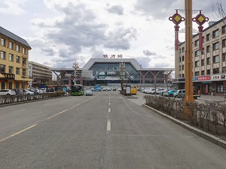
Photo adjustments
EXIF orientation normalized; resized without changing aspect ratio; converted to WebP. No subject edits.
- Administrative area
- County-level city · 县级市
- Part of
- Yichun
- Chinese name
- 铁力市
- Local areas
- County-level city guide
Area & population
- Area in the source
- 6,593.30 km²
- Population · 2010
- 235,158
Source: cited geographic source, as of the dates shown.
History
Tieli is popularly called Tieshanbao (铁山包), the name for a chain of hills around a knoll called Tieshan (铁山) in the south of today's city. Qing troops were stationed at Tieshanbao from April 1891, and a Qing garrison commander moved there in 1906. In 1915 a Tieli administrative bureau was set up in the old garrison office, and it became Tieli County (铁骊县) in 1933. In 1943 it was merged with Qingcheng County (庆城县) to form Qing'an County (庆安县); Tieli County was restored in 1946, merged into Qing'an again in 1958 and separated once more in 1962. On 19 November 1955 the State Council changed the written name from "铁骊" to "铁力" (both read Tieli), avoiding a rare character. Tieli became a county-level city in 1988, and in 2019 its Langxiang town (朗乡镇) was moved to the new Dajingshan County (大箐山县).
What to see
Riyuexia (日月峡) and Taoshan (桃山) are the city's two national forest parks. The Toulongshan scenic area (透龙山景区), the Taoshan scenic area with Xuanyang Peak (悬羊峰) and the Taoyuan Lake (桃源湖) tourist area are rated 4A. In winter the city government describes Toulongshan as a place to relive the forest region's great logging campaigns, with more than 20 ice-and-snow viewpoints and forest hikes.
The Riyuexia ski area is rated SSSS, the national grade for ski resorts. It has beginner, intermediate and advanced runs totalling more than 5,000 metres and a 1,400-metre double chairlift. At the Ma Yongshun forest farm (马永顺林场) in Riyuexia town, 38 km from the city, the Ma Yongshun Memorial Hall (马永顺纪念馆) tells the life of the forest worker Ma Yongshun and recalls the generations of forestry workers headed by him, through photographs, paintings, sculpture, reconstructed scenes and objects.
Beixing village (北星村) in Gongnong township (工农乡) is listed as a national key village for rural tourism, and the Nianfeng Korean Ethnic Township (年丰朝鲜族乡) as a national key town for rural tourism.
Food and local products
More than 200 kinds of medicinal plants grow in the area. Tieli flat-bulb fritillary (铁力平贝母), Tieli schisandra (铁力北五味子), Tieli forest-frog oil and Tieli rice carry national geographical-indication status.
Getting oriented
The Suijia railway (绥佳铁路) runs through the city, with passenger stations at Tieli, Shuangfeng (双丰), Wangyang (王杨), Taoshan and Shenshu (神树). China National Highway 222 and the Hegang–Harbin expressway (鹤哈高速) also cross the city.
Highlights
- Ma Yongshun Memorial Hall 马永顺纪念馆: Memorial to the forest worker Ma Yongshun at the Ma Yongshun forest farm, 38 km from the city.
- Riyuexia ski area 日月峡滑雪场: SSSS-rated, with runs totalling over 5,000 metres and a 1,400-metre chairlift.
- Toulongshan scenic area 透龙山景区: 4A scenic area with winter logging-campaign experiences and ice-and-snow viewpoints.
- Taoshan Xuanyang Peak 桃山悬羊峰: Part of the 4A Taoshan scenic area.
- Tieli flat-bulb fritillary 铁力平贝母: National geographical-indication product.
Sources for this guide
铁力市 - 维基百科,自由的百科全书 · Chinese Wikipedia · CC BY-SA 4.0
【“五一”出游】一一马永顺纪念馆_游-景区景点及路线_铁力市人民政府 · Tieli Municipal People's Government (Tieli Culture, Sports, Radio, Television and Tourism Bureau)
邂逅日月峡滑雪场、透龙山景区~_游-景区景点及路线_铁力市人民政府 · Tieli Municipal People's Government (Tieli Culture, Sports, Radio, Television and Tourism Bureau)
Original English written from the listed sources and checked sentence by sentence against quoted extracts by a separate reviewer. Updated 2026-09-24.
Explore Tieli
Core places to explore, with English and Chinese names.
Places to explore around Tieli
 AI illustration · AI
 Plan your visit
Getting there
Tieli is about 105 km in a straight line from central Yichun. Search for 铁力市 in a map app to find stations and your accommodation.
Where to stay →Build your route
Start with Taoshan Xuanyang Peak. The linked place guides have entrance and visit details.
Continue with Yichun →More in Yichun
Sources & geographic information
Administrative names and parent areas: Official geographic directory · Reference date 2026-09-06.
Some facts checked against 铁力市 — Wikipedia contributors, CC BY-SA 4.0.
Map data © OpenStreetMap contributors. Pins mark approximate centres, not entrances or boundaries.