


Get to know Jia County
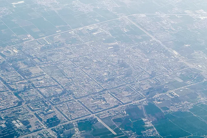
Photo adjustments
Full frame retained; proportionally resized and converted to WebP. No retouching or changes to the photographed subject. Card displays may crop the view.
- Administrative area
- County · 县
- Part of
- Pingdingshan
- Chinese name
- 郏县
- Local areas
- County guide
Area & population
- Area in the source
- 727.00 km²
- Population · 2019
- 577,600
Source: cited geographic source, as of the dates shown.
Setting and landscape
The county is saddle-shaped: low hills of the Waifang range (外方山) rise in the south-east, the Qishan uplands (萁山) in the north-west, and between them lies the alluvial plain of the Beiru River (北汝河), the county's largest river, which flows west to east through it for 48 kilometres. The highest point is Sanguan Mountain (三管山), 790.8 metres, where Jia meets Ruzhou (汝州) and Yuzhou (禹州). Jiaxian station on the Zhengzhou-Wanzhou high-speed railway (郑万高铁) opened in 2019.
History
Under King Kang of Zhou (周康王) the place was called Jia (夹) and lay within the royal domain of Chengzhou (成周). In the Spring and Autumn period it was the town of Jia, held first by Zheng (郑) and then by Chu (楚), and the Qin made it Jia County. It was renamed Longshan (龙山) in 493 and Jiacheng (郏城) in 608, was abolished in 1266 and restored as Jia County in 1304.
What to see
The Three Su Garden (三苏园), 23 kilometres north-west of the county town below the hill called Little Emei (小峨眉), is the resting place of Su Xun (苏洵) and his sons Su Shi and Su Zhe. A national key cultural relic and 4A scenic area, it takes in Guangqing Temple (广庆寺), the Three Su Shrine (三苏祠) and a stele forest.
The Jia County Confucian Temple (郏县文庙) stands on the east side of South Street in the old town. First built in 954 and rebuilt as the official temple in 1206, it runs through seven courtyards, with the school on the left and the temple on the right, and keeps 22 buildings. The county government rates its wood and stone carving and painted decoration the best among county-level Confucian temples in China; it is a national key cultural relic.
Food and local products
Jia County heluo (郏县饸饹) noodles were first made from buckwheat and served in mutton broth with sliced cooked mutton and scallions; wheat flour replaced buckwheat in the late Qing. Tofu vermicelli stew (豆腐粉条菜), from Xuedian town (薛店镇), is seasoned with fennel, star anise, chilli, pepper and cinnamon. Jia roast chicken (郏县烧鸡) is free-range chicken slow-simmered in an aged master stock, eaten hot with flatbread in Xizhai village (西寨村). The county grows no tea; its tea water is prized for the water itself, drawn from mineral springs at Yaozhuang (姚庄) and the Lan (蓝河) and Qinglong (青龙河) rivers. Jia red cattle (郏县红牛) are one of China's eight fine yellow-cattle breeds.
Highlights
- Three Su Garden 三苏园: Resting place of Su Xun, Su Shi and Su Zhe; national key cultural relic and 4A scenic area.
- Jia County Confucian Temple 郏县文庙: Founded in 954, rebuilt in 1206; seven courtyards and 22 surviving buildings.
- Jia County heluo 郏县饸饹: Pressed noodles in mutton broth, made with wheat since the late Qing.
- Jia red cattle 郏县红牛: One of China's eight fine yellow-cattle breeds.
Sources for this guide
[区域位置]-郏县人民政府门户网站 · Jia County People's Government
[自然环境]-郏县人民政府门户网站 · Jia County People's Government
[历史沿革]-郏县人民政府门户网站 · Jia County People's Government
[景区景点]-郏县人民政府门户网站 (三苏园景区) · Jia County People's Government
[名优特产]-郏县人民政府门户网站 · Jia County People's Government
[景区景点]-郏县人民政府门户网站 (郏县文庙景区) · Jia County People's Government
Original English written from the listed sources and checked sentence by sentence against quoted extracts by a separate reviewer. Updated 2026-09-24.
Explore Jia County
Core places to explore, with English and Chinese names.
Jia County 郏县
Plan your visit
Getting there
Jia County is about 25 km in a straight line from central Pingdingshan. Search for 郏县 in a map app to find stations and your accommodation.
Where to stay →More in Pingdingshan
Sources & geographic information
Administrative names and parent areas: Official geographic directory · Reference date 2026-09-06.
Map data © OpenStreetMap contributors. Pins mark approximate centres, not entrances or boundaries.