


Get to know Huangchuan County
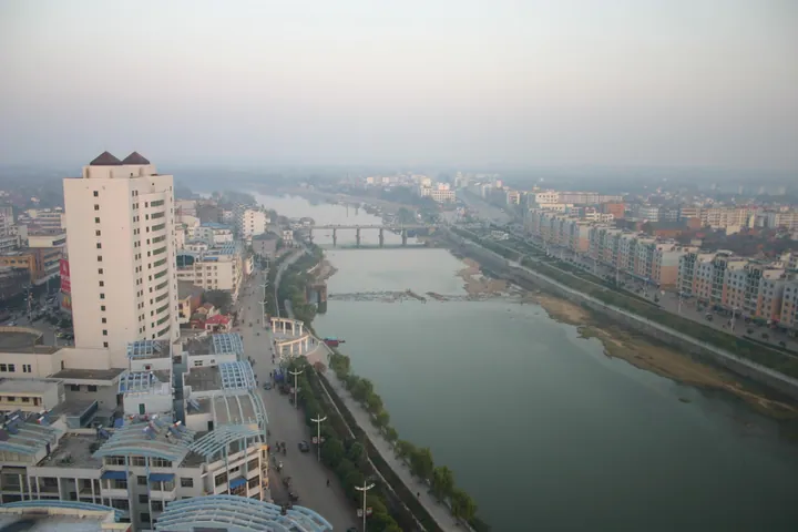
Photo adjustments
Full frame retained; proportionally resized and converted to WebP. No retouching or changes to the photographed subject. Card displays may crop the view.
- Administrative area
- County · 县
- Part of
- Xinyang
- Chinese name
- 潢川县
- Local areas
- County guide
Area & population
- Area in the source
- 1,638.00 km²
- Population · 2019
- 676,500
Source: cited geographic source, as of the dates shown.
Setting and landscape
The county occupies the belt where alluvial fans below the Dabie Mountains give way to the Huaibei Plain (淮北平原). Low ridges such as Huaifeng (淮凤岗), Qili (七里岗) and Huangsi (黄寺岗) alternate with the Zhai (寨河), Huang (潢河), Bailu (白露河) and Chun (春河) rivers, while the Huai runs east along the northern edge. Ridge land covers about two-thirds of the county, with low hills in the south and flat land along the rivers. The Huang River flows through the county town and divides it into a northern and a southern half. The climate is a monsoon climate on the transition from subtropical to warm temperate.
History
The town grew from the capital of the Huang state (黄国), which Chu (楚) conquered in 648 BC; Huang is regarded as the origin of the Jiangxia branch of the Huang (黄) surname. Huangchuan is also named as the home of Huang Xie (黄歇), Lord Chunshen (春申君) of the Warring States period. In 712 the seat of Guang Prefecture moved from Guangshan (光山) to Dingcheng (定城), the name the town had carried since 570, and in 1724 the Qing court raised Guang to a directly administered prefecture.
What to see
The site of the Huang State capital (黄国故城), in Longgu township (隆古乡) about 5 km north-west of the county town, is a national key protected site from the Spring and Autumn period. Its rammed-earth walls enclose a rectangle about 6.7 km round and still stand 5 to 7 metres high. Inside the walls, 15 disused wells and 12 bronze-workshop sites have been found, and a palace site stands 2 to 3 metres high.
Food and local products
Huangchuan soft-shelled turtle (潢川甲鱼) and Huangchuan sweet osmanthus (潢川金桂) are both Chinese geographical-indication products, and the osmanthus is the county flower. The county is a national demonstration base for flowers and nursery trees, growing more than 200 genera.
Getting oriented
National highways 312 and 106 and the Shanghai–Shaanxi (沪陕高速) and Daqing–Guangzhou (大广高速) expressways meet at the county town, and two national railways, the Nanjing–Xi'an (宁西) and Beijing–Kowloon (京九) lines, cross here. Neighbours include Gushi (固始), Guangshan (光山), Shangcheng (商城), Xi County (息县) and Huaibin (淮滨).
Highlights
- Huang State capital site 黄国故城: Spring and Autumn capital of the Huang state with rammed-earth walls 5 to 7 metres high; national key protected site.
- Huangchuan soft-shelled turtle 潢川甲鱼: Chinese geographical-indication product.
- Huangchuan sweet osmanthus 潢川金桂: Chinese geographical-indication product and the county flower.
Sources for this guide
潢川概况 行政区划 潢川县人民政府 · Huangchuan County People's Government
潢川县 - 维基百科,自由的百科全书 · Wikipedia (Chinese) · CC BY-SA 4.0
黄国故城 - 维基百科,自由的百科全书 · Wikipedia (Chinese) · CC BY-SA 4.0
Original English written from the listed sources and checked sentence by sentence against quoted extracts by a separate reviewer. Updated 2026-09-24.
Explore Huangchuan County
Core places to explore, with English and Chinese names.
Huangchuan County 潢川县
Plan your visit
Getting there
Huangchuan County is about 90 km in a straight line from central Xinyang. Search for 潢川县 in a map app to find stations and your accommodation.
Where to stay →More in Xinyang
Sources & geographic information
Administrative names and parent areas: Official geographic directory · Reference date 2026-09-06.
Some facts checked against 潢川县 — Wikipedia contributors, CC BY-SA 4.0.
Some facts checked against 黄国故城 — Wikipedia contributors, CC BY-SA 4.0.
Map data © OpenStreetMap contributors. Pins mark approximate centres, not entrances or boundaries.