


Get to know Shihe District

Photo adjustments
Full frame retained; EXIF orientation normalized, proportionally resized to at most 800 pixels and converted to WebP. No generated pixels or subject changes. Cards may crop the display.
- Administrative area
- District · 市辖区
- Part of
- Xinyang
- Chinese name
- 浉河区
- Local areas
- District guide
Area & population
- Area in the source
- 1,783.00 km²
- Population · 2019
- 674,900
Source: cited geographic source, as of the dates shown.
Setting and landscape
The ground falls from south-west to north-east, from 906 metres to 54 metres: the Tongbai (桐柏山) and Dabie ranges rise in the west and south, while the east and north are plain laid down by the Huai. The Huai runs along the northern edge and its tributary the Shi crosses the district, one of 15 perennial rivers that include the Du (杜河), Dongshuang (东双河) and Tanjia (谭家河). Yingshan (应山) and Dawu (大悟) in Hubei border it to the south and Suizhou (随州) to the west, with Luoshan (罗山) and Pingqiao (平桥) on the east and north.
What to see
The district's party secretary sums up Shihe on CCTV as "one mountain, one water, one tea garden". The mountain is Mount Jigong (鸡公山), a Dabie spur on the Henan–Hubei border 38 km south of Xinyang, whose main peak, Rooster Head (鸡公头), reaches 814 metres. It became a national key scenic area in 1982 and a national nature reserve in 1988, and between 1898 and 1936 about 500 villas were built on it by people from 23 countries, among them the United States, Britain, France, Germany and Russia.
The water is Nanwan Lake (南湾湖), a reservoir built between 1952 and 1955 by damming the Shi in the district's south-west, about 5 km from the city. Mao Zedong's words "The Huai River must be harnessed" (一定要把淮河修好) are set into the face of its 816.5-metre dam. Migratory egrets and herons have long used Bird Island, and there are also Monkey and Tea islands. Xianyin Temple (贤隐寺), founded in the Southern Dynasties, stands in a valley at the lake's east end.
Food and local products
Shihe is the main producing area of Xinyang Maojian (信阳毛尖) green tea, with more than 600,000 mu (about 40,000 hectares) of tea gardens. The hills upstream of Nanwan Lake, known as the "five clouds and two pools" (五云二潭) and including Cheyun Mountain (车云山) and Black Dragon Pool (黑龙潭), are its main growing area. The top grade is picked as one bud with one leaf just opening, and the traditional method fires the leaves in two iron woks before drying them over charcoal. At Hejiazhai (何家寨) in Shihegang town (浉河港镇), an RV campsite sits on the high tea hills beside the lake, and Victory Road pedestrian street (胜利路步行街) in the city carries reliefs of the Maojian-making process.
Getting oriented
Xinyang station (信阳站) on the Beijing–Guangzhou railway is in the district, and the district government sits in Hudong subdistrict (湖东街道).
Highlights
- Mount Jigong 鸡公山: 814-metre Dabie spur with about 500 villas built by people from 23 countries between 1898 and 1936.
- Nanwan Lake 南湾湖: Reservoir on the Shi built 1952–1955, with Mao's inscription on the dam and Bird, Monkey and Tea islands.
- Xianyin Temple 贤隐寺: Temple founded in the Southern Dynasties at the east end of Nanwan Lake.
- Xinyang Maojian 信阳毛尖: Green tea grown mainly in Shihe, especially in the hills upstream of Nanwan Lake.
Sources for this guide
自然地理-信阳市浉河区人民政府 · Shihe District People's Government, Xinyang
行政区划-信阳市浉河区人民政府 · Shihe District People's Government, Xinyang
《乡约河南信阳浉河区 给茶乡医生说媒》节目文稿_三农频道_央视网 · CCTV (cctv.com)
深入学习贯彻党的二十大精神丨浉河区:茶旅融合拥抱美好生活 · Henan Daily (via Dahe.cn, republished by Xinxiang Daily online)
鸡公山 - 维基百科,自由的百科全书 · Wikipedia (Chinese) · CC BY-SA 4.0
南湾水库 - 维基百科,自由的百科全书 · Wikipedia (Chinese) · CC BY-SA 4.0
信阳毛尖 - 维基百科,自由的百科全书 · Wikipedia (Chinese) · CC BY-SA 4.0
浉河区 - 维基百科,自由的百科全书 · Wikipedia (Chinese) · CC BY-SA 4.0
Original English written from the listed sources and checked sentence by sentence against quoted extracts by a separate reviewer. Updated 2026-09-24.
Explore Shihe District
Core places to explore, with English and Chinese names.
Places to explore around Shihe District
 Temple gate on Mount Jigong in mist, Xinyang · 鸡公山活佛禅寺山门(云雾),信阳市 Source-recorded photograph date: 2010-04-18 10:34:04.
Mount Jigong鸡公山
Jigong Mountain is known for a landscape of wooded slopes and historic summer villas near the Henan–Hubei boundary. The villas reflect the international community that used the mountain as a retreat in the late nineteenth and…
Read the place guide →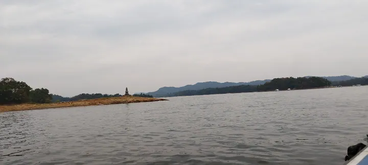 Nanwan Reservoir with its small tea island, Xinyang · 信阳南湾湖茶岛 Source-recorded photograph date: 5 October 2024 (according to Exif data).
Nanwan Reservoir南湾湖
Nanwan Lake combines a broad reservoir landscape with islands developed around local tea and wildlife themes. Tea Island links the visit to Xinyang’s tea-growing culture, while Bird Island provides a wooded contrast to the open…
Read the place guide →Plan your visit
Getting there
Shihe District is about 5 km in a straight line from central Xinyang. Search for 浉河区 in a map app to find stations and your accommodation.
Where to stay →Build your route
Mount Jigong and Nanwan Reservoir are about 35 km apart in a straight line. The linked place guides have entrance and visit details.
Continue with Xinyang →More in Xinyang
Sources & geographic information
Administrative names and parent areas: Official geographic directory · Reference date 2026-09-06.
Some facts checked against 鸡公山 — Wikipedia contributors, CC BY-SA 4.0.
Some facts checked against 南湾水库 — Wikipedia contributors, CC BY-SA 4.0.
Some facts checked against 信阳毛尖 — Wikipedia contributors, CC BY-SA 4.0.
Some facts checked against 浉河区 — Wikipedia contributors, CC BY-SA 4.0.
Photo: Mount Jigong · Gary Lee Todd, Ph.D. · CC0. Full frame retained; proportionally resized and converted to WebP. No retouching or changes to the photographed subject. Card displays may crop the view.
_-_10323711716.jpg)
Photo: Nanwan Reservoir · Whzizhi · CC BY-SA 4.0. Full frame retained; proportionally resized and converted to WebP. No retouching or changes to the photographed subject. Card displays may crop the view.

Map data © OpenStreetMap contributors. Pins mark approximate centres, not entrances or boundaries.