


Get to know Xihua County
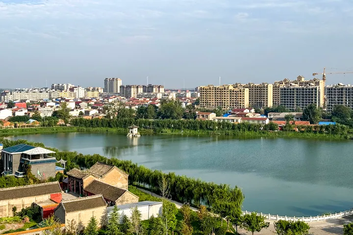
Photo adjustments
Full frame retained; proportionally resized and converted to WebP. No retouching or changes to the photographed subject. Card displays may crop the view.
- Administrative area
- County · 县
- Part of
- Zhoukou
- Chinese name
- 西华县
- Local areas
- County guide
Area & population
- Area in the source
- 1,208.00 km²
- Population · 2019
- 737,000
Source: cited geographic source, as of the dates shown.
Setting and landscape
The land sits 48 to 56 metres above sea level. The Sha, Ying and Jialu run 69, 65 and 33 kilometres through the county, all within the Huai River system. After the Yellow River dikes were breached at Huayuankou (花园口) in 1938, Xihua lay at the heart of the flood zone.
History
The name goes back to the Spring and Autumn period, when the Hua (华) clan of the state of Song lived around present-day Niedui (聂堆镇): those to the east were the Eastern Hua, those to the west the Western Hua. In the Ming and Qing the river town of Xiaoyao (逍遥镇) was a trading port, counted with Luohe (漯河), Zhoukou and Jieshou (界首) among the four great docks of the Sha River; a new Xiaoyao port on the Sha began trial operation in June 2022.
What to see
Nüwa City (女娲城), about ten kilometres north of the county town, is a group of traditional-style buildings that includes Nüwa's tomb (女娲陵), a Hall of Mending the Sky (补天殿) and a Fuxi Hall (伏羲殿), with statues and murals of Nüwa making people and repairing the sky. A temple fair gathers there on the first and fifteenth of each lunar month; the site became a national AAA scenic area in 2017.
The Tomb of King Wuding of Shang (商高宗武丁陵) lies 15 kilometres northeast of the county town at Lingxi village (陵西村) in Tiankou township (田口乡). Records say Wuding came to Xihua to fight a plague of locusts and died here; the surviving mound is about six metres high and over a hundred metres across. In the county town, the Jizi Reading Terrace (箕子读书台) stands in a lake, traditionally where Jizi (箕子) hid and studied.
Food and local products
Xiaoyao is known for hulatang, a peppery thick soup; the Xiaoyao hot pepper soup technique (逍遥胡辣汤制作技艺) became national intangible heritage in 2021. China's intangible-heritage centre describes a stock of beef bone, mutton and crucian carp with more than twenty spices, filled out with meat, wheat gluten, starch noodles and daylily, and eaten with sesame oil, aged vinegar and pan-fried buns. The recipe is traced to a Ming imperial cook, Zhao Qi (赵杞), whose Gao and Wang heirs are now in their fourteenth generation.
Getting oriented
The Zhengzhou–Fuyang high-speed railway, opened in 2019, stops at Xihua Station on the east side of Huatai subdistrict (华泰街道). The Daqing–Guangzhou and Shangqiu–Nanyang expressways cross the county.
Highlights
- Nüwa City 女娲城: Traditional-style halls and Nüwa's tomb about 10 km north of the county town; temple fair on the 1st and 15th of each lunar month; AAA scenic area since 2017.
- Tomb of King Wuding of Shang 商高宗武丁陵: Mound about 6 m high at Lingxi village, Tiankou township, 15 km northeast of the county town.
- Xiaoyao hot pepper soup 逍遥胡辣汤: Peppery soup of beef-bone, mutton and crucian-carp stock from Xiaoyao town; national intangible heritage since 2021.
Sources for this guide
西华县 - 维基百科,自由的百科全书 · Wikipedia (Chinese) · CC BY-SA 4.0
女娲城_西华县人民政府门户网站 · Xihua County People's Government
商高宗武丁陵_西华县人民政府门户网站 · Xihua County People's Government
小吃制作技艺(逍遥胡辣汤制作技艺) - 中国非物质文化遗产网 · China Intangible Cultural Heritage Network (ihchina.cn)
Original English written from the listed sources and checked sentence by sentence against quoted extracts by a separate reviewer. Updated 2026-09-24.
Explore Xihua County
Core places to explore, with English and Chinese names.
Xihua County 西华县
Plan your visit
Getting there
Xihua County is about 20 km in a straight line from central Zhoukou. Search for 西华县 in a map app to find stations and your accommodation.
Where to stay →More in Zhoukou
Sources & geographic information
Administrative names and parent areas: Official geographic directory · Reference date 2026-09-06.
Some facts checked against 西华县 — Wikipedia contributors, CC BY-SA 4.0.
Map data © OpenStreetMap contributors. Pins mark approximate centres, not entrances or boundaries.