


Get to know Danjiangkou
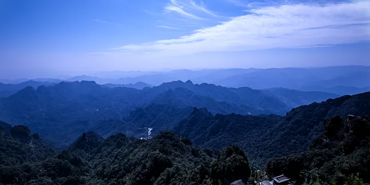
Photo adjustments
Full frame retained; proportionally resized and converted to WebP. No retouching or changes to the photographed subject. Card displays may crop the view.
- Administrative area
- County-level city · 县级市
- Part of
- Shiyan
- Chinese name
- 丹江口市
- Local areas
- County-level city guide
Area & population
- Area in the source
- 3,121.00 km²
- Population · 2020
- 409,940
Source: cited geographic source, as of the dates shown.
History
The Danjiangkou city government counts more than 2,200 years of administrative history here: a Wudang County (武当县) set up under the Qin, renamed Junzhou (均州) in the Sui and Tang, and Jun County (均县) under the Republic. When the Danjiangkou water-control project was built from 1958, the old county town was flooded completely and a new town was built beside the dam. Jun County became Danjiangkou city in August 1983.
Setting and landscape
The reservoir spans Hubei and Henan, lying mainly in Danjiangkou and in Xichuan County (淅川县) of Nanyang. It is fed by the Han, the Dan and the Xi (淅水). The first phase of the middle route of the South–North Water Diversion (南水北调) brought the reservoir's total area to 1,022.75 square kilometres; the reservoir is that route's only source. At its widest, on the Hubei–Henan border, the open water is more than 30 km long and 20 km wide and is nicknamed the 'Little Pacific'. The climate is subtropical, semi-humid and monsoonal.
What to see
The Wudang peaks known as a Taoist centre lie in Wudangshan subdistrict (武当山街道). The first sacred building, the Five Dragons Temple, was built at the order of Emperor Taizong of Tang; the largest complex on the mountain was built under the Ming, when the Yongle Emperor claimed the protection of the god Xuantian Shangdi (玄天上帝). The oldest surviving structures are the Golden Hall and the Ancient Bronze Shrine of 1307, and the stone-walled compound of the Taihe Palace (太和宫) at the peak dates from 1419. The temple complex became a UNESCO World Heritage Site in 1994. Niuhe Forest Park (牛河森林公园) is another of the city's scenic areas.
Two traditions from Danjiangkou are on the national intangible-heritage list. Wujiagou folk tales (伍家沟民间故事), listed in 2006, come from Wujiagou, a village in Liuliping town (六里坪镇) where more than a thousand stories were recorded in the 1980s, including legends of Wudang and of Chen Shimei (陈世美). Wudang shenxi (武当神戏), listed in 2011, is a family opera of the Wang clan of Qingtang village in Xijiadian town (习家店镇), tied to Taoist rites for the gods of Wudang.
Highlights
- Wudang Mountains 武当山: Taoist temple complex with Ming buildings; UNESCO World Heritage Site since 1994.
- Danjiangkou Reservoir 丹江口水库: Sole source of the middle route of the South–North Water Diversion; 1,022.75 sq km of water.
- Wujiagou folk tales 伍家沟民间故事: Village storytelling tradition on the national intangible-heritage list since 2006.
- Wudang shenxi 武当神戏: Wang-family opera linked to Taoist rites; national intangible heritage since 2011.
Sources for this guide
丹江口概况 - 丹江口概况 - 十堰市委市政府门户网站 · Danjiangkou Municipal People's Government
丹江口市 - 维基百科,自由的百科全书 · Wikipedia (Chinese) · CC BY-SA 4.0
Wudang Mountains - Wikipedia · Wikipedia (English) · CC BY-SA 4.0
伍家沟民间故事 - 中国非物质文化遗产网·中国非物质文化遗产数字博物馆 - 中国非物质文化遗产网非遗 · China Intangible Cultural Heritage Network (Chinese National Academy of Arts)
武当神戏 - 中国非物质文化遗产网·中国非物质文化遗产数字博物馆 - 中国非物质文化遗产网非遗 · China Intangible Cultural Heritage Network (Chinese National Academy of Arts)
丹江口水库 - 维基百科,自由的百科全书 · Wikipedia (Chinese) · CC BY-SA 4.0
Original English written from the listed sources and checked sentence by sentence against quoted extracts by a separate reviewer. Updated 2026-09-24.
Explore Danjiangkou
Core places to explore, with English and Chinese names.
Places to explore around Danjiangkou
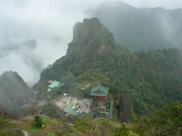 A temple pavilion on a misty peak of Wudang Mountain, Danjiangkou · 丹江口武当山云雾缭绕的山峰与庙宇 Source-recorded photograph date: 2005-05-21 11:21:16.
Wudang Mountains武当山
Daoist range in Danjiangkou, Hubei, where the Yongle Emperor built 33 palaces and temples from 1412; a World Heritage Site since 1994.
Read the place guide → AI illustration · AI 示意图(仅供参考,非该地点实拍)
Danjiangkou Reservoir Viewing Area丹江口水库开放观景区
The Danjiangkou Reservoir (丹江口水库) is the engineered lake behind the Danjiangkou Dam in Danjiangkou City, Shiyan, north-western Hubei, and is the source of water for the middle route of the South-to-North Water Diversion. The catalogue entry is an editorial grouping for the publicly visitable shoreline and dam area rather than a single named attraction.
Read the place guide →Plan your visit
Getting there
Danjiangkou is about 70 km in a straight line from central Shiyan. Search for 丹江口市 in a map app to find stations and your accommodation.
Where to stay →Build your route
Wudang Mountains and Danjiangkou Reservoir Viewing Area are both listed here. The linked place guides have entrance and visit details.
Continue with Shiyan →More in Shiyan
Sources & geographic information
Administrative names and parent areas: Official geographic directory · Reference date 2026-09-06.
Some facts checked against 丹江口市 — Wikipedia contributors, CC BY-SA 4.0.
Some facts checked against Wudang Mountains — Wikipedia contributors, CC BY-SA 4.0.
Some facts checked against 丹江口水库 — Wikipedia contributors, CC BY-SA 4.0.
Photo: Wudang Mountains · Unknown author · Public domain. Full frame retained; proportionally resized and converted to WebP. No retouching or changes to the photographed subject. Card displays may crop the view.

Map data © OpenStreetMap contributors. Pins mark approximate centres, not entrances or boundaries.