


Get to know Yiling District

Photo adjustments
Full frame retained; resized proportionally to a maximum dimension of 960 pixels and converted to WebP quality 88. No crop, retouch, generated elements, or subject alteration. Final website rendition: full frame retained, proportionally resized to at most 720 pixels and converted to WebP. No additional retouching or subject alteration. Card displays may crop the view.
- Administrative area
- District · 市辖区
- Part of
- Yichang
- Chinese name
- 夷陵区
- Local areas
- District guide
Area & population
- Area in the source
- 3,424.00 km²
- Population · 2020
- 534,408
Source: cited geographic source, as of the dates shown.
History
In the Warring States period the area belonged to Chu, was already called Yiling and served as a burial ground for Chu kings. The Han set up Yiling County; the Ming raised it to Yiling Subprefecture in 1376, and in 1735 the Qing made it Yichang Prefecture. In 1912 the prefecture was abolished and Yichang County created. Construction of the Gezhouba Dam (葛洲坝) moved the county seat to Xiaoxita (小溪塔) in July 1970, and on 28 July 2001 the county became Yiling District.
The Northern Song writer Ouyang Xiu (欧阳修) wrote an essay on the Zhixi Hall (至喜堂) of Yiling County, and the district takes its tourism slogan, "arrive and rejoice", from it. Among the district's own list of cultural symbols are the Chinese sturgeon, its oranges and tea, Yichang silk-and-bamboo music (宜昌丝竹) and Yiling prints (夷陵版画). The district counts four national intangible-heritage items; the Yangtze boatmen's chants (峡江号子) and shadow puppetry are staged in its scenic areas.
What to see
Three of Yichang's four national 5A tourist areas are in Yiling: the Three Gorges Dam, Sanxia Renjia (三峡人家) and the Three Gorges Waterfall (三峡大瀑布). The district describes the 39.6-kilometre G348 road along the gorge as a scenic route that passes views of the dam, Sanxia Renjia and Huangling Temple (黄陵庙). Sanyou Cave (三游洞) is among the core scenic areas.
The Three Gorges Waterfall area lies in Huanghua Town (黄花镇) within the Yangtze Three Gorges National Geopark and covers 24 square kilometres; it was made a 5A area in July 2022. Its main fall is 102 metres high and 80 metres wide, and a walkway runs behind the lower part of the fall. The area also holds the Xiaofeng Cambrian and Huanghua Ordovician geological sites and the Golden Lion Cave (金狮洞), a 1,853-metre cave of stalactites, stalagmites and flowstone named after a lion-shaped formation. Local weeding gongs and drums (薅草锣鼓) are performed there.
Baili Huang (百里荒) has a high-mountain snowfield with skiing; the district presents it as a long-established ski area of southern China.
Highlights
- Three Gorges Dam 三峡大坝: In Yiling; one of the district's three national 5A areas.
- Three Gorges Waterfall 三峡大瀑布: 102 m main fall in Huanghua Town with a walkway behind it; 5A since July 2022.
- Sanxia Renjia 三峡人家: National 5A area along the G348 gorge road.
- Golden Lion Cave 金狮洞: 1,853 m stalactite cave in the waterfall area, named after a lion-shaped formation.
- Baili Huang 百里荒: High-mountain snowfield promoted as a long-established southern ski area.
Sources for this guide
夷陵区 - 维基百科,自由的百科全书 · Wikipedia (Chinese) · CC BY-SA 4.0
夷陵区 - 重点产业园区 - 宜昌市人民政府 · Yichang City People's Government (Investment Promotion Bureau)
“天下三峡 至喜夷陵”文旅品牌新闻发布会举行-三峡夷陵网-|-三峡夷陵新闻门户网站 · Sanxia Yiling Net (Yiling District Media Centre)
三峡大瀑布成功创建5A级景区 · Jingchu Net (Hubei Daily)
国家5A级旅游景区三峡大瀑布 · China Tourism News
Original English written from the listed sources and checked sentence by sentence against quoted extracts by a separate reviewer. Updated 2026-09-25.
Explore Yiling District
Core places to explore, with English and Chinese names.
Places to explore around Yiling District
 A traditional sailboat on the river gorge at Three Gorges Tribe (San Xia Ren Jia), Yichang · 宜昌三峡人家景区,江面上的传统帆船 Source-recorded photograph date: 2010-07-31 08:51:49.
Three Gorges Tribe三峡人家
Three Gorges Tribe combines Xiling Gorge scenery with a staged presentation of local river and hill life. Longjin Stream brings bridges, boats and waterside houses into a sheltered valley, while the higher Bawangzhai area offers…
Read the place guide →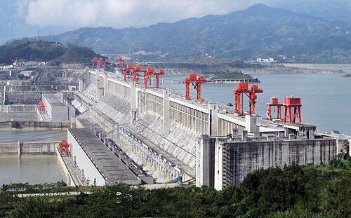 Three Gorges Dam Project · 三峡大坝
Three Gorges Dam三峡大坝
The Three Gorges Dam visit is organised around viewing areas that explain a vast working water-engineering project. Tanziling gives the broadest reading of the dam and ship-lock arrangement; the 185 Platform brings the reservoir…
Read the place guide → The Three Gorges Waterfall (Baiguoshu Waterfall) in Yiling District, Yichang · 三峡大瀑布(白果树瀑布),夷陵区,宜昌市 Source-recorded photograph date: 2018-03-31 11:26:00.
Three Gorges Waterfall三峡大瀑布
Three Gorges Waterfall is an inland gorge walk in Yiling, separate from the Yangtze dam and cruise route. Smaller cascades, rock walls and wooded stream sections lead towards the main fall. Its best-known close-up experience…
Read the place guide → Bailihuang Grassland · 百里荒
Bailihuang Grassland百里荒
Bailihuang (百里荒) is a high grassland plateau in Fenxiang Town, Yiling District, north of Yichang, covering about 40 square kilometres at an average elevation of 1,200 metres and managed as a national 4A scenic area.
Read the place guide →Plan your visit
Getting there
Yiling District is about 9 km in a straight line from central Yichang. Search for 夷陵区 in a map app to find stations and your accommodation.
Where to stay →Build your route
Three Gorges Tribe and Three Gorges Dam are about 15 km apart in a straight line. The linked place guides have entrance and visit details.
Continue with Yichang →More in Yichang
Sources & geographic information
Administrative names and parent areas: Official geographic directory · Reference date 2026-09-06.
Some facts checked against 夷陵区 — Wikipedia contributors, CC BY-SA 4.0.
Photo: Three Gorges Tribe · Zbingo · CC BY-SA 3.0. Full frame retained; proportionally resized and converted to WebP. No retouching or changes to the photographed subject. Card displays may crop the view.

Photo: Three Gorges Dam · Source file : Le Grand Portage Derivative work: Rehman · CC BY 2.0. Wikimedia thumbnail; fitted to the ranking-card frame.

Photo: Three Gorges Waterfall · Fxqf · CC BY-SA 4.0. Full frame retained; proportionally resized and converted to WebP. No retouching or changes to the photographed subject. Card displays may crop the view.

Photo: Bailihuang Grassland · Fxqf · CC BY-SA 4.0. EXIF orientation normalized; resized without changing aspect ratio; converted to WebP. No subject edits.

Map data © OpenStreetMap contributors. Pins mark approximate centres, not entrances or boundaries.