


Get to know Xiling District

Photo adjustments
Full frame retained; proportionally resized and converted to WebP. No retouching or changes to the photographed subject. Card displays may crop the view.
- Administrative area
- District · 市辖区
- Part of
- Yichang
- Chinese name
- 西陵区
- Local areas
- District guide
Area & population
- Area in the source
- 89.90 km²
- Population · 2020 census
- 537,686
- Administrative seat
- Xiling Subdistrict
Source: cited geographic source, as of the dates shown.
Setting and landscape
Across the Yangtze to the southwest lies Dianjun District (点军区); to the southeast the district meets Yiling (夷陵区) and Wujiagang (伍家岗区), and in the north it runs into the hills of Yiling. It is divided into ten subdistricts, among them Xiba (西坝) and Gezhouba (葛洲坝), plus a provincial-level economic development zone.
History
The district government traces the area back to a western frontier stronghold of the state of Chu (楚) in the Spring and Autumn and Warring States periods. Under the Western Han it was Yiling County (夷陵县) in Nan Commandery (南郡). In AD 222 the kingdom of Wu (吴) renamed Yiling as Xiling, the first time a seat in the Yichang area took the name Xiling. Later names include Xiazhou (峡州) under the Tang, Yiling Zhou (夷陵州) from 1376 and Donghu County (东湖县) from 1735, under Yichang Prefecture.
The Yichang city government also records that Guo Pu (郭璞) worked on his commentary to the ancient dictionary Erya (《尔雅》) in Xiling. The State Council approved the creation of Xiling District on 13 December 1986, and it was formally founded when its first People's Congress met on 18 November 1987.
What to see
The Gezhouba Dam (葛洲坝), which the city government calls the first dam on the Yangtze, stands within the district, and the headquarters of the Three Gorges Project (三峡工程) is also based here. Chinese Wikipedia counts 45 research institutions and ten colleges in the district.
Highlights
- Gezhouba Dam 葛洲坝: Water-control project on the Yangtze inside the district, described by the Yichang city government as the first dam on the river.
Sources for this guide
西陵区情 - 西陵区情 - 宜昌市西陵区人民政府 · Xiling District People's Government, Yichang
西陵区 - 重点产业园区 - 宜昌市人民政府 · Yichang Municipal People's Government (Investment Promotion Bureau)
西陵区 - 维基百科,自由的百科全书 · Chinese Wikipedia · CC BY-SA 4.0
Original English written from the listed sources and checked sentence by sentence against quoted extracts by a separate reviewer. Updated 2026-09-24.
Explore Xiling District
Core places to explore, with English and Chinese names.
Places to explore around Xiling District
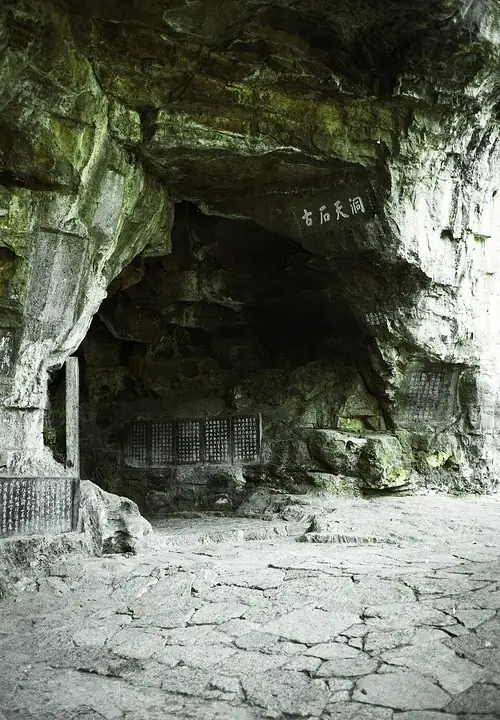 Sanyou Cave entrance and rock chamber, Yichang · 宜昌三游洞洞口与石室 Photograph date recorded by the source: October 2006.
Three Visitors Cave and Park三游洞
Sanyou Cave links a small limestone chamber with a long literary memory. Its name recalls the visit associated with Bai Juyi, Bai Xingjian and Yuan Zhen, whose poetry helped turn this Xiling Gorge setting into a cultural…
Read the place guide → AI illustration · AI 示意图(仅供参考,非该地点实拍)
Zhenjiang Pavilion Riverside镇江阁江畔
Zhenjiang Pavilion (镇江阁) stands on the bank of the Yangtze at Yichang, about 4,000 metres below the Gezhouba water-control project, and the catalogue entry covers the pavilion together with the stretch of riverside park that runs past it. The four-storey building seen today is a reconstruction, on a new site, of a pavilion first built in 1699.
Read the place guide →Plan your visit
Getting there
Xiling District covers the centre of Yichang. Search for 西陵区 in a map app to find stations and your accommodation.
Where to stay →Build your route
Three Visitors Cave and Park and Zhenjiang Pavilion Riverside are both listed here. The linked place guides have entrance and visit details.
Continue with Yichang →More in Yichang
Sources & geographic information
Administrative names and parent areas: Official geographic directory · Reference date 2026-09-06.
Some facts checked against 西陵区 — Wikipedia contributors, CC BY-SA 4.0.
Photo: Three Visitors Cave and Park · Gisling · Gisling — Sanyoudong2.jpg — CC BY-SA 3.0 · CC BY-SA 3.0. The exact downloaded source bytes are separately retained and hashed. Prepared JPEG is proportionally reduced to a maximum 720-pixel long edge; full frame retained, no subject alteration. Final website rendition: full frame retained, proportionally resized to at most 720 pixels and converted to WebP. No additional retouching or subject alteration. Card displays may crop the view.

Map data © OpenStreetMap contributors. Pins mark approximate centres, not entrances or boundaries.