


Get to know Chengbu Miao Autonomous County

Photo adjustments
Full frame retained; proportionally resized and converted to WebP. No retouching or changes to the photographed subject. Card displays may crop the view.
- Administrative area
- Autonomous county · 自治县
- Part of
- Shaoyang
- Chinese name
- 城步苗族自治县
- Local areas
- Autonomous county guide
Area & population
- Area in the source
- 2,647.00 km²
- Population · 2017
- 292,033
- Administrative seat
- Rulin
Source: cited geographic source, as of the dates shown.
Setting and landscape
The county is high to the east, south and west and opens to the north, with the Nanling range along its southern border and a narrow, gentler strip in the north and centre. Elevations run from 326 to 2,021 metres, averaging about 697 metres; the highest summit is Erbaoding (二宝顶). The county straddles two great basins: the Wu, Hao (郝水) and Qu (渠水) rivers drain north to the Yangtze, while the Xun River (浔水) flows south to the Pearl River system. The Zi River (资水), the Wu, the Qu and the Xun all rise inside the county, and the Wu is the largest river within it.
History
The county government traces human activity back to a Neolithic site at Chaoyuanli (朝园里) in Xiyan town (西岩镇). The first county here, Wuyou (武攸), was set up at the end of the Sui with its seat at today's Rulin town (儒林镇), which is still the county seat. Early in the Song the Wugang county seat moved away and the old seat became Chengbu stockade (城步寨), the first use of the name Chengbu.
After the Ming put down a Miao uprising led by Li Zaiwan (李再万) in 1502, northern Chengbu became the first Miao area in China where hereditary native chiefs were replaced by appointed officials. Chengbu County was formed from parts of Wugang and Suining in 1504 under Baoqing Prefecture. On 30 November 1956 the State Council replaced the county with the Chengbu Miao Autonomous County.
What to see and understand
The Nanshan National Scenic Area (南山国家级风景名胜区) in Nanshan town is hill and mountain country topped by upland pastures, and Chinese Wikipedia lists the Nanshan Pasture (南山牧场) in Chengbu as a national 3A scenic area. The county also contains Hunan Nanshan National Park (湖南南山国家公园). The Baiyun Reservoir (白云水库) stretches 19.6 kilometres by water and is scattered with islands.
The Chengbu hanging dragon (城步吊龙), danced in Xiatuan village (下团村) of Dankou town (丹口镇), entered the national intangible heritage list in 2011. Cloth-covered bamboo dragon sections hang from a frame of shoulder poles and red cords raised on two-metre bamboo poles, so the dragon seems to wheel through clouds. When the dragon arrives at a village gate or hall, both sides exchange greetings in Miao ritual verse.
Food and local products
Chengbu wheel-wingnut tea (城步青钱柳茶) is a national geographical-indication product: fresh leaves of the Chinese wheel wingnut tree (青钱柳) are heated, rolled, sorted and dried, then steeped like tea.
Highlights
- Nanshan National Scenic Area 南山国家级风景名胜区: Hill and mountain scenic area in Nanshan town with upland pastures.
- Chengbu hanging dragon 城步吊龙: Dragon dance of Xiatuan village on the national intangible heritage list since 2011.
- Baiyun Reservoir 白云水库: Island-dotted reservoir 19.6 kilometres long by water.
- Chengbu wheel-wingnut tea 城步青钱柳茶: Geographical-indication leaf tea made from the Chinese wheel wingnut tree.
Sources for this guide
自然地理 · Chengbu Miao Autonomous County People's Government
历史沿革 · Chengbu Miao Autonomous County People's Government
城步苗族自治县 · Wikipedia · CC BY-SA 4.0
龙舞(城步吊龙) · China Intangible Cultural Heritage Network (ihchina.cn)
南山国家级风景名胜区 · Wikipedia · CC BY-SA 4.0
Original English written from the listed sources and checked sentence by sentence against quoted extracts by a separate reviewer. Updated 2026-09-24.
Explore Chengbu Miao Autonomous County
Core places to explore, with English and Chinese names.
Places to explore around Chengbu Miao Autonomous County
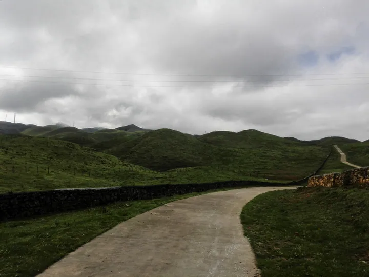 A road winding through the green rolling grassland of Nan Shan Pasture, Chengbu Miao Autonomous County ·
 Plan your visit
Getting there
Chengbu Miao Autonomous County is about 150 km in a straight line from central Shaoyang. Search for 城步苗族自治县 in a map app to find stations and your accommodation.
Where to stay →Build your route
Start with Nanshan Pasture. The linked place guides have entrance and visit details.
Continue with Shaoyang →More in Shaoyang
Sources & geographic information
Administrative names and parent areas: Official geographic directory · Reference date 2026-09-06.
Some facts checked against 城步苗族自治县 — Wikipedia contributors, CC BY-SA 4.0.
Some facts checked against 南山国家级风景名胜区 — Wikipedia contributors, CC BY-SA 4.0.
Photo: Nanshan Pasture · Qiu Mao · CC BY 3.0. Full frame retained; proportionally resized and converted to WebP. No retouching or changes to the photographed subject. Card displays may crop the view.
.jpg)
Map data © OpenStreetMap contributors. Pins mark approximate centres, not entrances or boundaries.