


Get to know Beita District
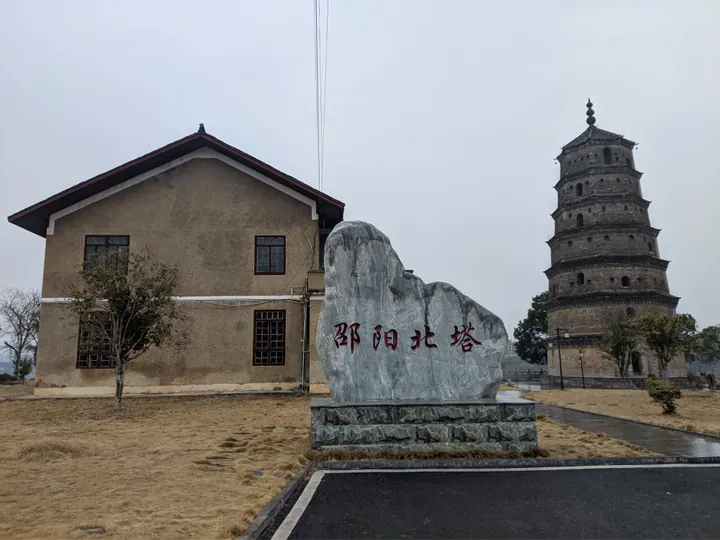
Photo adjustments
Full frame retained; proportionally resized and converted to WebP. No retouching or changes to the photographed subject. Card displays may crop the view.
- Administrative area
- District · 市辖区
- Part of
- Shaoyang
- Chinese name
- 北塔区
- Local areas
- District guide
Area & population
- Area in the source
- 84.25 km²
- Population · 2020 census
- 122,658
- Administrative seat
- Zhuangyuanzhou Subdistrict
Source: cited geographic source, as of the dates shown.
Setting and landscape
Beita lies in the Hengyang-Shaoyang hill basin (衡邵丘陵盆地): rolling low hills with river-valley flats set between them. The Zi River runs west to east through the whole district, and the district government counts two-thirds of its villages on the riverbank. Beita borders Xinshao County (新邵县) to the north and Shaoyang County (邵阳县) to the south and southwest. The climate is mid-subtropical and monsoonal, with four clear seasons and a mean annual temperature of about 17°C.
What to see
The Shaoyang North Pagoda (邵阳北塔) stands on the north bank where the Zi and Shao (邵水) rivers meet, across from the East Pagoda and the Tingwaiting pavilion (亭外亭) on Dizhu rock (砥柱矶). Planning began in 1570, building started in 1573 and the work was finished in the tenth year of the Wanli reign. The seven-storey brick and stone tower is 26 metres tall; the eaves of its lower three storeys are faced with dressed stone and the roof tiles carry lotus patterns. Its finial is three stacked iron vases, one of which was shaken loose in a Japanese air raid during the war against Japan.
Che Daren (车大任), a Ming official from Shaoyang, wrote that the low, open ground where the rivers turn north needed a pagoda for feng shui. A North Pagoda Temple and the Wunian Pavilion (无念阁) were later built beside it, making the site a Buddhist place in the Ming and Qing periods. The State Council listed the pagoda as a major historical and cultural site protected at the national level in June 2001.
Food and local products
The dragon-tooth lily (龙牙百合) of Chenjiaqiao (陈家桥) has been grown for more than 300 years and is known for thick, tender, pure-white bulbs. Baitian radish (白田萝卜) from Chayuantou (茶元头) is shaped like a clay pot; raw it is juicy and crisp like lotus root, and cooked it turns smooth and soft.
Getting oriented
National Highway 320 crosses the district east to west, and National Highway 207 runs north to south. Five bridges, the First and Second Zijiang bridges and the Xihu, Xuefeng and Guihua bridges, link Beita to the city centre.
Highlights
- Shaoyang North Pagoda 邵阳北塔: Seven-storey, 26-metre Ming pagoda at the meeting of the Zi and Shao rivers; national protected site since 2001.
- Dragon-tooth lily 龙牙百合: Lily bulbs grown in Chenjiaqiao for more than 300 years.
- Baitian radish 白田萝卜: Pot-shaped radish from Chayuantou, crisp raw and soft when cooked.
Sources for this guide
北塔概况 · Beita District People's Government
Beita, Shaoyang · Wikipedia · CC BY-SA 4.0
邵阳北塔 · Wikipedia · CC BY-SA 4.0
Original English written from the listed sources and checked sentence by sentence against quoted extracts by a separate reviewer. Updated 2026-09-24.
Explore Beita District
Core places to explore, with English and Chinese names.
Beita District 北塔区
Plan your visit
Getting there
Beita District covers the centre of Shaoyang. Search for 北塔区 in a map app to find stations and your accommodation.
Where to stay →More in Shaoyang
Sources & geographic information
Administrative names and parent areas: Official geographic directory · Reference date 2026-09-06.
Some facts checked against Beita, Shaoyang — Wikipedia contributors, CC BY-SA 4.0.
Some facts checked against 邵阳北塔 — Wikipedia contributors, CC BY-SA 4.0.
Map data © OpenStreetMap contributors. Pins mark approximate centres, not entrances or boundaries.