


Get to know Shaodong
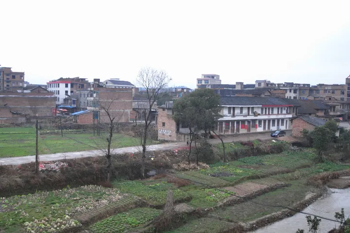
Photo adjustments
Full frame retained; proportionally resized and converted to WebP. No retouching or changes to the photographed subject. Card displays may crop the view.
- Administrative area
- County-level city · 县级市
- Part of
- Shaoyang
- Chinese name
- 邵东市
- Local areas
- County-level city guide
Area & population
- Area in the source
- 1,778.47 km²
- Population · 2020
- 1,038,416
Source: cited geographic source, as of the dates shown.
Setting and landscape
Low hills and mounds cover about 61 percent of Shaodong and mountains about 22 percent; flat land is mostly narrow valley floor. The city sits in the transition zone between the Xuefeng Mountains (雪峰山) and the Nanling ranges (南岭), with raised ground in the middle acting as a watershed. The Shao River (邵水) drains west to the Zi River (资江), while the Zheng (蒸水) and Ce (测水) rivers flow east to the Xiang River (湘江). Springs tend to be wet and autumns dry, and the city government describes summers as long and winters as short.
History
In 5 AD the Western Han created the Zhaoyang marquisate (昭阳侯国) at today's Tongyi village (同意村) in Dahetang (大禾塘) subdistrict. The Eastern Han made it Zhaoyang county, and in 280 it was renamed Shaoyang to avoid the name of Sima Zhao (司马昭), so the first county called Shaoyang was governed from Yujiaqiao (余家桥) in present-day Shaodong; the seat moved to the modern city of Shaoyang in 581. Shaodong county was split off in 1952 and took its name from lying in the old county's eastern district. It became a county-level city in 2019.
What to see
The city government's list of sights starts with three hills: Mount Dayun (大云山), where the Tang scholar Shen Taizhi (申太芝) lived; Mount Shehu (佘湖山), with an inscription from Tang Emperor Suzong and an old temple; and Jiulong Ridge (九龙岭), where the Song philosopher Zhou Dunyi (周敦颐) is said to have washed his ink. It also names the Yinjiatang (荫家堂) mansion complex, Hong Bridge (洪桥) and a grove of thousand-year-old maples at Changdaochong (长道冲) in Shuidongjiang (水东江). Hunan's provincial heritage list also covers the site of the Han-era Zhaoyang marquisate town and the former home of the composer He Luting (贺绿汀).
Food and local products
Shaodong daylily (黄花菜) and Shaodong Solomon's seal (玉竹) are both on China's list of protected geographical-indication products. Lianqiao (廉桥) holds a specialist market for Chinese medicinal materials. Other local products are pig-blood tofu balls (猪血丸子), cured pork, camellia oil, Shetianqiao (佘田桥) tofu and Shetianqiao water chestnuts.
Getting oriented
Shaodong borders Shaoyang County and Shaoyang's Shuangqing (双清) district to the west, Shuangfeng (双峰) and Hengyang (衡阳) counties to the east, Qidong (祁东) to the south, and Xinshao (新邵) and Lianyuan (涟源) to the north. The Loudi–Shaoyang (娄邵) and Huaihua–Hengyang (怀衡) railways pass through, with stations at Shaodong and Yangqiao (杨桥), and the G60 Shanghai–Kunming (沪昆) and S80 Hengyang–Shaoyang (衡邵) expressways cross the city.
Highlights
- Mount Shehu 佘湖山: Hill with an inscription attributed to Tang Emperor Suzong and an old temple.
- Yinjiatang 荫家堂: Large merchant mansion complex under national heritage protection.
- Hong Bridge 洪桥: Ming-dynasty bridge on Hunan's provincial heritage list.
- Shaodong daylily 邵东黄花菜: Protected geographical-indication product that gives Shaodong its "home of golden needles" name.
Sources for this guide
邵东市 - 维基百科,自由的百科全书 · Chinese Wikipedia · CC BY-SA 4.0
邵东自然环境概述 · Shaodong Municipal People's Government
Original English written from the listed sources and checked sentence by sentence against quoted extracts by a separate reviewer. Updated 2026-09-24.
Explore Shaodong
Core places to explore, with English and Chinese names.
Plan your visit
Getting there
Shaodong is about 25 km in a straight line from central Shaoyang. Search for 邵东市 in a map app to find stations and your accommodation.
Where to stay →More in Shaoyang
Sources & geographic information
Administrative names and parent areas: Official geographic directory · Reference date 2026-09-06.
Some facts checked against 邵东市 — Wikipedia contributors, CC BY-SA 4.0.
Map data © OpenStreetMap contributors. Pins mark approximate centres, not entrances or boundaries.