


Get to know Wugang
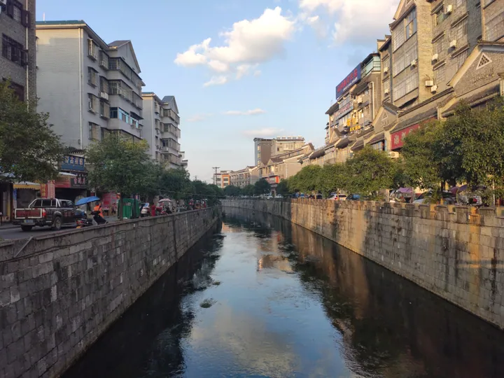
Photo adjustments
Full frame retained; proportionally resized and converted to WebP. No retouching or changes to the photographed subject. Card displays may crop the view.
- Administrative area
- County-level city · 县级市
- Part of
- Shaoyang
- Chinese name
- 武冈市
- Local areas
- County-level city guide
Area & population
- Area in the source
- 1,549.00 km²
- Population · 2017
- 843,000
Source: cited geographic source, as of the dates shown.
Setting and landscape
Mountains enclose Wugang on three sides, and the land slopes from the higher south to a low centre open to the north. The Zi enters from Chengbu (城步), crosses the middle of the city area and leaves for Dongkou (洞口). In the south rises Yunshan (云山), 1,372.5 metres high, on the northern edge of the Nanling Mountains; spurs of the Xuefeng range run along the west.
History
Wugang, once called Duliang (都梁), became a county in the Western Han, and a Duliang marquisate was created here in 124 BC. In 1106 the Song raised it to Wugang military prefecture (武冈军). In 1423 Zhu Pian (朱楩), eighteenth son of the Ming founder, was enfeoffed at Wugang as Prince of Min (岷王) and built his palace in the town, where the line lasted fourteen generations. The Southern Ming Yongli emperor later moved to Wugang and used the Min palace as his court. The county became a city in 1994.
What to see
The Wugang city wall (武冈城墙), built between the Song and the Qing, was named a national key cultural relic in the seventh batch. The old town is divided into a greater princely city, a lesser princely city and an outer town, with the Qu River (渠水) running through it. The city government's conservation plan names five historic quarters: Xizhi Street (西直街), Muhuo Street (木货街), Chuancheng River (穿城河), Hehe Street (和合街) and Taiping Gate (太平门). The site of the Second Branch of the Whampoa Military Academy (黄埔军校第二分校旧址), from 1938, is also on the national list.
The city government names the Confucian temple (文庙), the Yunshan scenic area and Faxiang Rock (法相岩) among its sights, and Langshi (浪石), a village of old houses, is a provincial historic and cultural village.
Food and local products
Wugang calls itself the "capital of Chinese braised food" (中国卤菜之都), a title given in 2007. Chicken, duck, goose, beef, pork, mutton, tofu and eggs all go into the braising pot; apart from a few large firms, braised food is made in family workshops with their own recipes, and the city government says local braised food was sent to the Ming court as tribute. Other traditional foods named by the city are rice puffs (米花), duck in blood sauce (血酱鸭), rice noodles, tofu and the Wugang copper goose (武冈铜鹅), one of Hunan's "three treasures".
Highlights
- Wugang city wall 武冈城墙: Song-to-Qing wall, a national key cultural relic in the seventh batch.
- Site of the Second Branch of the Whampoa Military Academy 黄埔军校第二分校旧址: 1938 site on the national key cultural relic list.
- Yunshan 云山: Mountain of 1,372.5 metres in the south of the city, on the northern edge of the Nanling range.
- Wugang braised food 武冈卤菜: Meats, tofu and eggs braised in family workshops; Wugang was named capital of Chinese braised food in 2007.
- Wugang copper goose 武冈铜鹅: Local goose breed counted among Hunan's three treasures.
Sources for this guide
自然地理_武冈市人民政府 · Wugang Municipal People's Government
历史沿革_武冈市人民政府 · Wugang Municipal People's Government
《湖南省武冈历史文化名城保护规划》公示说明_通知公告公示_武冈市人民政府 · Wugang Municipal People's Government
湖南省全国重点文物保护单位名录(第一批~第七批)-湖南省文物局 · Hunan Provincial Cultural Relics Bureau
市情介绍_武冈市人民政府 · Wugang Municipal People's Government
武冈卤菜_名优特产_武冈市人民政府 · Wugang Municipal People's Government
Original English written from the listed sources and checked sentence by sentence against quoted extracts by a separate reviewer. Updated 2026-09-24.
Explore Wugang
Core places to explore, with English and Chinese names.
Plan your visit
Getting there
Wugang is about 100 km in a straight line from central Shaoyang. Search for 武冈市 in a map app to find stations and your accommodation.
Where to stay →More in Shaoyang
Sources & geographic information
Administrative names and parent areas: Official geographic directory · Reference date 2026-09-06.
Map data © OpenStreetMap contributors. Pins mark approximate centres, not entrances or boundaries.