


Get to know Yanling County

Photo adjustments
Full frame retained; proportionally resized and converted to WebP. No retouching or changes to the photographed subject. Card displays may crop the view.
- Administrative area
- County · 县
- Part of
- Zhuzhou
- Chinese name
- 炎陵县
- Local areas
- County guide
Area & population
- Area in the source
- 2,030.00 km²
- Population · 2020
- 160,274
Source: cited geographic source, as of the dates shown.
Setting and landscape
The county government sums up its land as eight and a half parts mountain, one part fields and half a part water and estates. Jinggangshan City (井冈山市) and Suichuan County (遂川县) in Jiangxi lie to the east, Chaling County (茶陵县) to the north and Guidong County (桂东县) to the south. The government lists Lingfeng (酃峰), at 2,122.35 metres, as the highest peak in Hunan, and gives about 100,000 mu of primeval forest and a forest cover of 83.55 percent, which it ranks first in the province.
History
The county was carved out of Chaling in 1211, under the Southern Song, and was long called Ling County (酃县). In 1994 it was renamed Yanling after the mausoleum. It was one of the six core counties of the Jinggangshan revolutionary base: the county government records that Mao Zedong and Zhu De held their first meeting here, and that land was first redistributed here by staking out plots with signboards.
What to see
The Yan Emperor Mausoleum stands at Luyuanpo (鹿原陂), west of the county town. It is a nationally protected monument and a 5A scenic area, and the Yan Emperor memorial ceremony (炎帝陵祭典) was in the first national intangible-heritage list. Shennong Valley National Forest Park (神农谷国家森林公园), a 4A scenic area, is promoted for the high negative-ion count of its air. A museum of Red Army slogans, also rated 4A and described as the first of its kind in China, preserves 339 Red Army slogans.
Food and local products
Yanling yellow peaches (炎陵黄桃) and Yanling white geese (炎陵白鹅) are both registered as national geographical-indication farm products.
Highlights
- Yan Emperor Mausoleum 炎帝陵: At Luyuanpo west of the county town; national protected monument and 5A scenic area.
- Shennong Valley National Forest Park 神农谷国家森林公园: 4A scenic area promoted for the negative-ion count of its air.
- Red Army slogan museum 红军标语博物馆: 4A site preserving 339 Red Army slogans.
- Yanling yellow peach 炎陵黄桃: National geographical-indication product.
Sources for this guide
炎陵县情简介-炎陵县人民政府门户网 · Yanling County People's Government
炎陵县 - 维基百科,自由的百科全书 · Wikipedia (Chinese) · CC BY-SA 4.0
Original English written from the listed sources and checked sentence by sentence against quoted extracts by a separate reviewer. Updated 2026-09-25.
Explore Yanling County
Core places to explore, with English and Chinese names.
Places to explore around Yanling County
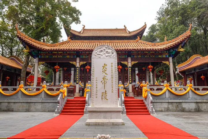 Memorial stele and main hall at the Mausoleum of the Yan Emperor, Yanling County · 炎陵县炎帝陵主殿及陵碑 Source-recorded photograph date: 2025-01-23 13:44:05.
Mausoleum of the Yan Emperor炎帝陵
The Yan Emperor Mausoleum at Luyuan is a ceremonial landscape associated with Yandi, also identified with the legendary culture hero Shennong. Halls, courtyards and inscribed memorials express a long tradition of ancestral…
Read the place guide → AI illustration · AI 示意图(仅供参考,非该地点实拍)
Shennong Valley神农谷
Shennonggu (神农谷) is a national forest park in the northeast of Yanling County, Zhuzhou, Hunan, set on the northwest slope of the northern Wanyang Mountains in the middle of the Luoxiao range along the Hunan-Jiangxi border.
Read the place guide →Plan your visit
Getting there
Yanling County is about 160 km in a straight line from central Zhuzhou. Search for 炎陵县 in a map app to find stations and your accommodation.
Where to stay →Build your route
Mausoleum of the Yan Emperor and Shennong Valley are both listed here. The linked place guides have entrance and visit details.
Continue with Zhuzhou →More in Zhuzhou
Sources & geographic information
Administrative names and parent areas: Official geographic directory · Reference date 2026-09-06.
Some facts checked against 炎陵县 — Wikipedia contributors, CC BY-SA 4.0.
Photo: Mausoleum of the Yan Emperor · N509FZ · CC BY-SA 4.0. Full frame retained; proportionally resized and converted to WebP. No retouching or changes to the photographed subject. Card displays may crop the view.
.jpg)
Map data © OpenStreetMap contributors. Pins mark approximate centres, not entrances or boundaries.