


Get to know Ongniud Banner
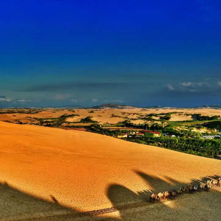
Photo adjustments
EXIF orientation normalized; resized without changing aspect ratio; converted to WebP. No subject edits.
- Administrative area
- Banner · 旗
- Part of
- Chifeng
- Chinese name
- 翁牛特旗
- Local areas
- Banner guide
Area & population
- Area in the source
- 11,870.00 km²
- Population · 2020
- 333,970
- Administrative seat
- Wudan
Source: cited geographic source, as of the dates shown.
Setting and landscape
The banner is a long strip, about 256 km from west to east and 84 km from north to south, where the southwestern Greater Khingan meets the northern end of the Qilaotu Mountains (七老图). The highest point is Sanchadang Mountain (三岔裆山) at 2,020 m, the source of the Yangchang (羊肠河), Shaolang (少郎河) and Weitang (苇塘河) rivers. The land falls to 286 m where the Xar Moron (西拉沐沦河) meets the Laoha River (老哈河); on the eastern plain, dunes cover more than 60% of the ground, and the river meadows carry herds and rice paddies. About three quarters of the year's rain falls in summer.
History
Ongniud is a Mongolian name, rendered in Chinese as "the king's people". The banner calls itself the home of the dragon and phoenix (龙凤之乡) after two finds: a large jade dragon of the Hongshan culture, more than 5,000 years old, unearthed at Sanxingtala (三星他拉) in the 1970s, and a pottery phoenix cup (陶凤杯).
The Liao founding emperor set the "Southern Tower" (南楼), one of the four Khitan towers, at Yongzhou (永州), made a prefecture in 981; its ruins lie in Xinsumo Sumu (新苏莫苏木). Fengzhou, founded in 995, stood on the site of today's Wudan. In the Yuan the area belonged to the Khongirad (弘吉剌部), and in 1295 the city of Quanning (全宁城) was built at the northwest corner of present-day Wudan. The banner government names the Yuan grand princess Sengge Ragi (祥哥剌吉), who married here, as China's first woman collector.
What to see
The banner lists 413 heritage sites, three of them national protected sites. They include the Shangyao (上窑) Palaeolithic cave dwellings, the ruins of Liao Yongzhou, the Yuan tombs of Zhang Yingrui (张应瑞), the Xiangshui cliff inscriptions (响水摩崖石刻) carrying poems from the Qianlong Emperor's eastern tour, and the Qing-dynasty Fanzong Temple (梵宗寺).
Yulong Sand Lake (玉龙沙湖) became a national 4A scenic area in 2013. The banner's page on it calls the resort Bolongke Sand Lake (勃隆克沙湖), in Wudan town 118 km from Chifeng, with desert, grassland, rocky peaks and a lake; Bolongke means "strange round stone mountain" in Mongolian. Hongshan Lake (红山湖) in the east is described by the banner as the largest man-made reservoir by area in Inner Mongolia, and the Denglonghe grassland (灯笼河草原) lies in the west.
Food and local products
Ongniud sunflower seeds, tomatoes, beef and rice are among seven local products certified as named quality farm products in China, and the banner's 2026 overview says nai guozi (奶果子) will soon follow.
Highlights
- Yulong Sand Lake 玉龙沙湖: National 4A scenic area since 2013; the banner's page on it describes sand, grassland, rocky peaks and a lake.
- Fanzong Temple 梵宗寺: Qing-dynasty temple listed among the banner's heritage sites.
- Xiangshui cliff inscriptions 响水摩崖石刻: Rock-cut poems from the Qianlong Emperor's eastern tour.
- Hongshan Lake 红山湖: Described by the banner as Inner Mongolia's largest man-made reservoir by area.
Sources for this guide
翁牛特旗人民政府-翁旗简介 · Ongniud Banner People's Government
翁牛特旗人民政府-历史沿革 · Ongniud Banner People's Government
翁牛特旗人民政府-自然地理 · Ongniud Banner People's Government
翁牛特旗人民政府-旅游景点 · Ongniud Banner People's Government
Original English written from the listed sources and checked sentence by sentence against quoted extracts by a separate reviewer. Updated 2026-09-25.
Explore Ongniud Banner
Core places to explore, with English and Chinese names.
Ongniud Banner 翁牛特旗
Plan your visit
Getting there
Ongniud Banner is about 75 km in a straight line from central Chifeng. Search for 翁牛特旗 in a map app to find stations and your accommodation.
Where to stay →More in Chifeng
Sources & geographic information
Administrative names and parent areas: Official geographic directory · Reference date 2026-09-06.
Map data © OpenStreetMap contributors. Pins mark approximate centres, not entrances or boundaries.