


Get to know Bairin Left Banner
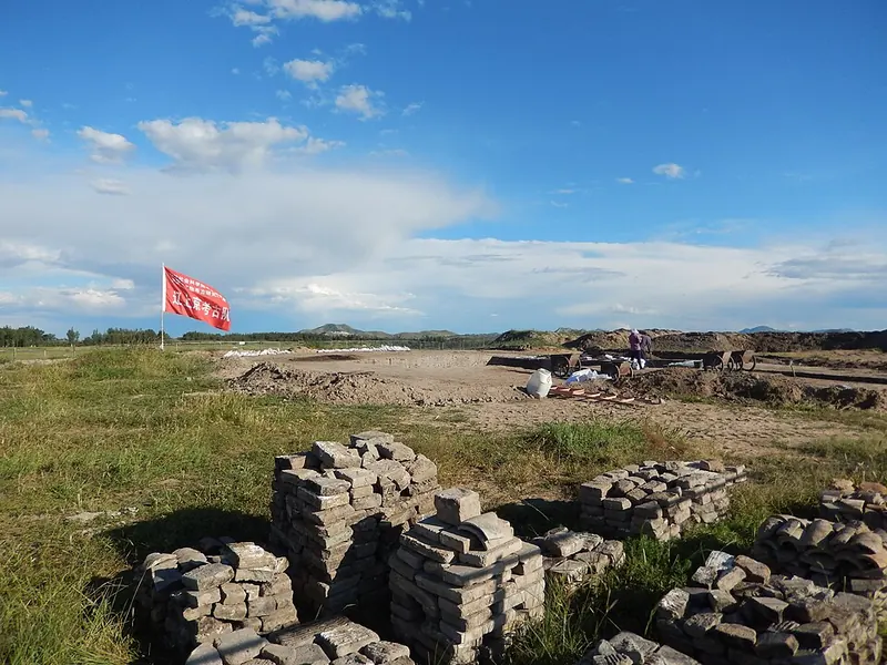
Photo adjustments
Full frame retained; proportionally resized and converted to WebP. No retouching or changes to the photographed subject. Card displays may crop the view.
- Administrative area
- Banner · 旗
- Part of
- Chifeng
- Chinese name
- 巴林左旗
- Local areas
- Banner guide
Area & population
- Area in the source
- 6,644.00 km²
- Population · 2020
- 277,522
- Administrative seat
- Lindong
Source: cited geographic source, as of the dates shown.
History
In 918 the Khitan ruler Yelü Abaoji (耶律阿保机) ordered a capital built here, choosing a site backed by hills with fertile land and water and pasture. The Upper Capital (上京临潢府) had a northern imperial city and a southern Han city, and served as the Liao political centre until the Jin took it in 1120. Much later the land passed to the Baarin (巴林) tribe; the Baarin joined the Later Jin in 1628, and the Bairin Left Wing Banner was created in 1648. In 1932 Lindong was made a county, which was abolished and merged into the banner in 1933. From 1947 to 1955 the banner hosted the headquarters of the Juu Uda League (昭乌达盟), and it joined Chifeng when the league became a city in 1983.
What to see
The Liao Upper Capital site (辽上京遗址), on the southeastern edge of Lindong, has been a Major Historical and Cultural Site Protected at the National Level since 1961 and has been on China's tentative World Heritage list since 2012. In 2022 the National Cultural Heritage Administration named it a national archaeological park, the first in Inner Mongolia. Excavations since 2011 have uncovered more than 20,000 objects, including clay statues and fragments of jade books. The Liao Upper Capital Museum (辽上京博物馆) was completed as part of the site works, and the capital's north and south pagodas have been restored.
Fifteen kilometres south of the capital, the Zhenji Temple caves (真寂之寺), also called the Houzhao Temple caves (后召庙石窟寺), were cut into a cliff of Taoshi Mountain (桃石山) as three chambers. The central one holds a reclining Shakyamuni surrounded by mourning disciples and more than a hundred small Buddhas; a lama temple added in the Qing stands in front. Other Liao and Jin remains in the banner include the Zuzhou (祖州) site with its Liao imperial mausoleum, the Han Kuangsi (韩匡嗣) family cemetery and the banner's stretch of the Jin border ramparts (金界壕).
Setting and landscape
The banner government lists three nationally designated landscapes: the Wulanba (乌兰坝) national nature reserve, the Qiguoshan (七锅山) national geopark and the Wulijimulun River (乌力吉沐沦河) national wetland park. National Highways 303 and 305 and the G5511 expressway cross the banner.
Highlights
- Liao Upper Capital site 辽上京遗址: Liao capital founded in 918; national archaeological park since 2022.
- Liao Upper Capital Museum 辽上京博物馆: Museum completed as part of the 2019-2022 works on the site.
- Zhenji Temple caves 真寂之寺: Liao cave temple 15 km south of the capital with a reclining Buddha.
- Qiguoshan National Geopark 七锅山国家地质公园: The banner's national geopark.
- Wulanba National Nature Reserve 乌兰坝国家级自然保护区: The banner's national nature reserve.
Sources for this guide
巴林左旗 - 维基百科,自由的百科全书 · Chinese Wikipedia · CC BY-SA 4.0
自然环境_ 巴林左旗概况_巴林左旗人民政府 · Bairin Left Banner People's Government
“失落的瑰宝”辽上京遗址 从历史中唤醒千年沉睡都城_ 历史文化_巴林左旗人民政府 · Chifeng Cultural Relics Bureau, on the Bairin Left Banner People's Government portal
巴林左旗辽代真寂之寺_ 历史文化_巴林左旗人民政府 · Bairin Left Banner People's Government
Original English written from the listed sources and checked sentence by sentence against quoted extracts by a separate reviewer. Updated 2026-09-26.
Explore Bairin Left Banner
Core places to explore, with English and Chinese names.
Places to explore around Bairin Left Banner
Plan your visit
Getting there
Bairin Left Banner is about 195 km in a straight line from central Chifeng. Search for 巴林左旗 in a map app to find stations and your accommodation.
Where to stay →Build your route
Start with Liao Upper Capital Ruins. The linked place guides have entrance and visit details.
Continue with Chifeng →More in Chifeng
Sources & geographic information
Administrative names and parent areas: Official geographic directory · Reference date 2026-09-06.
Some facts checked against 巴林左旗 — Wikipedia contributors, CC BY-SA 4.0.
Photo: Liao Upper Capital Ruins · BabelStone · CC BY-SA 3.0. Full frame retained; proportionally resized and converted to WebP. No retouching or changes to the photographed subject. Card displays may crop the view.

Map data © OpenStreetMap contributors. Pins mark approximate centres, not entrances or boundaries.