


Get to know Abag Banner
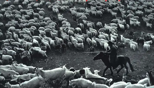
Photo adjustments
EXIF orientation normalized; resized without changing aspect ratio; converted to WebP. No subject edits.
- Administrative area
- Banner · 旗
- Part of
- Xilingol League
- Chinese name
- 阿巴嘎旗
- Local areas
- Banner guide
Area & population
- Area in the source
- 27,490.00 km²
- Population · 2020
- 38,589
- Administrative seat
- Biligtai
Source: cited geographic source, as of the dates shown.
Setting and landscape
The ground rolls gently without clear ranges or gullies, higher in the northeast and lower in the southwest, mostly between 960 and 1,500 metres. The banner government describes it as mainly typical steppe and one of the ten great natural pastures of Inner Mongolia, with 36 rivers and 10 lakes. The climate is semi-arid, with about 245 mm of precipitation a year and a frost-free season of about 103 days.
History
"Abag" means "uncle" in Mongolian: the tribe took the name because its chiefs descended from Belgutei (别里古台), half-brother of Genghis Khan. In the 17th century the Qing organised the Abag and Abaganar (阿巴哈纳尔) peoples into four hereditary banners under Xilingol League. They were combined into western and central united banners in 1948, merged into one in 1952 with its seat at Hanbei Temple (汉贝庙), and renamed Abag Banner in July 1956.
What to see
Hurchagan Nur (呼尔查干淖尔), 15 km southwest of Chagannaoer town (查干淖尔镇), is counted by the banner government among Inner Mongolia's four great freshwater lakes and is a habitat for Mongolian gazelles and swans. Uliastai (乌里雅斯台), 27 km southwest of Honggeergaole town (洪格尔高勒镇), is a sandy-land woodland of red willow and elm where 108 sand springs feed the Gegestai River (高格斯台河). Chinggis Bogd Mountain (成吉思宝格都山), a Quaternary volcanic basalt hill 35 km northwest of Beiligutai beside National Highway 331, takes its name from a north slope said to resemble Genghis Khan's upturned face. Haorige Mountain (浩日格山), more than 50 km north of Beiligutai, carries 168 rock carvings of animals, people and symbols.
Yangdu Temple (杨都庙) in Honggeergaole was founded in 1864 and named Shishan Temple (施善寺) by the Qing court. It is the only temple in the banner still holding religious activity, has been a regional protected monument since September 2006, and holds a fair every sixth lunar month. The Beiligutai Cultural Park (别力古台文化园), on the north side of Beiligutai, has a bronze statue of Belgutei as a wrestler and Turkic stone figures, and the Abag Banner Museum (阿巴嘎旗博物馆), in use since 2010, has a permanent exhibition of the banner's stone tools.
Food and local products
Abag Wuranke sheep (阿巴嘎乌冉克羊) and the Abag black horse (阿巴嘎黑马) are registered national geographical-indication certification marks. The banner promotes itself as China's home of black-horse culture and of mare's milk, and the banner government names Qinggele Baolige (青格勒宝力格) as the black horse's place of origin.
Highlights
- Hurchagan Nur 呼尔查干淖尔: Counted by the banner government among Inner Mongolia's four great freshwater lakes; home to Mongolian gazelles and swans.
- Yangdu Temple 杨都庙: Founded 1864; regional protected monument since 2006 and still an active temple.
- Chinggis Bogd Mountain 成吉思宝格都山: Basalt hill whose north slope is said to resemble Genghis Khan's face.
- Uliastai 乌里雅斯台: Sandy-land woodland fed by 108 sand springs.
- Abag black horse 阿巴嘎黑马: Registered geographical-indication mark.
Sources for this guide
阿巴嘎旗 - 维基百科,自由的百科全书 · Chinese Wikipedia · CC BY-SA 4.0
阿旗概况_阿巴嘎旗人民政府 · Abag Banner People's Government
旅游概况_阿巴嘎旗人民政府 · Abag Banner Culture, Sports, Tourism and Broadcasting Bureau
Original English written from the listed sources and checked sentence by sentence against quoted extracts by a separate reviewer. Updated 2026-09-26.
Explore Abag Banner
Core places to explore, with English and Chinese names.
Abag Banner 阿巴嘎旗
Plan your visit
Getting there
Abag Banner is about 75 km in a straight line from central Xilingol League. Search for 阿巴嘎旗 in a map app to find stations and your accommodation.
Where to stay →More in Xilingol League
Sources & geographic information
Administrative names and parent areas: Official geographic directory · Reference date 2026-09-06.
Some facts checked against 阿巴嘎旗 — Wikipedia contributors, CC BY-SA 4.0.
Map data © OpenStreetMap contributors. Pins mark approximate centres, not entrances or boundaries.