


Get to know East Ujimqin Banner
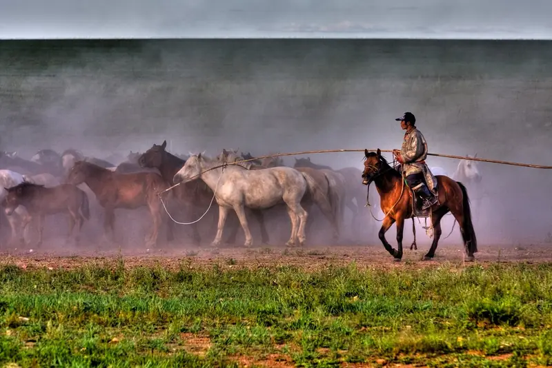
Photo adjustments
Full frame retained; EXIF orientation normalized, proportionally resized to at most 800 pixels and converted to WebP. No generated pixels or subject changes. Cards may crop the display.
- Administrative area
- Banner · 旗
- Part of
- Xilingol League
- Chinese name
- 东乌珠穆沁旗
- Local areas
- Banner guide
Area & population
- Area in the source
- 54,545.00 km²
- Population · 2020
- 94,076
- Administrative seat
- Uliastai
Source: cited geographic source, as of the dates shown.
Setting and landscape
Locally the banner is called "the western tip of the Greater Khingan, the eastern shore of the Erlian Basin". It stretches about 350 km east to west and 150 km north to south, with low hills in the north and basins in the south, at heights of roughly 800 to 1,500 metres; the highest peak, Baogeda Mountain (宝格达山), reaches 1,461 m. Winters are cold and windy under the Mongolian high: January averages -18.9°C and July 21°C, and about 300 mm of rain falls a year, 70 percent of it in June to August.
History
Ujimqin is the name of a Mongol tribe and is glossed as "people of the grape mountain". In the Ming this was pasture of the Ujimqin, and the Qing set up the Ujimqin Left Banner here early in the dynasty. In 1945 the banner's ruling prince, Minjuur Dorj (敏珠尔道尔吉), led six of its sumu units to the area near the Kherlen River (克鲁伦河) in Mongolia, where they have herded ever since. The land joined the Eastern United Banner in 1949, and East Ujimqin Banner was formed in 1956. The banner government calls East Ujimqin the homeland of long song (长调) and a cradle of bökh wrestling (搏克).
What to see
Inner Mongolia News lists Baogedawula National Forest Park (宝格达乌拉国家森林公园), Uliastai Mountain (乌里雅斯太山), Ejinur salt lake (额吉淖尔盐湖), known as the Mother Lake, and the Nailin Gol (乃林郭勒) wetland reserve among the banner's sights. The Inner Mongolia Yearbook records that the Baogedawula forest farm became a national forest park in 2010 and is the source of the Ulagai River (乌拉盖河), the region's largest inland river. The Zuun Khatavch (珠恩嘎达布其) crossing, 68 km north of Uliastai, is listed as the third year-round international land port in Inner Mongolia.
Food and local products
The banner is the home of the Ujimqin sheep (乌珠穆沁羊), a large coarse-wool breed with a short fat tail, raised for both meat and fat and known for fast-growing lambs; the banner government quotes its reputation as "ginseng among meats" and a royal tribute. The banner has also been awarded the title of China's home of the Huangbiao horse (黄骠马).
Highlights
- Baogedawula National Forest Park 宝格达乌拉国家森林公园: National forest park since 2010 and source of the Ulagai River.
- Ejinur salt lake 额吉淖尔盐湖: Salt lake known as the Mother Lake.
- Zuun Khatavch crossing 珠恩嘎达布其口岸: Year-round international land port 68 km north of Uliastai.
- Ujimqin sheep 乌珠穆沁羊: Large fat-tailed breed native to the Ujimqin grassland.
Sources for this guide
东乌珠穆沁旗 - 维基百科,自由的百科全书 · Chinese Wikipedia · CC BY-SA 4.0
自然地理_东乌珠穆沁旗人民政府 · East Ujimqin Banner People's Government
历史沿革_东乌珠穆沁旗人民政府 · East Ujimqin Banner People's Government
东乌概况_东乌珠穆沁旗人民政府 · East Ujimqin Banner People's Government
东乌珠穆沁旗:千里边境线上的草原明珠-新闻中心-内蒙古新闻网 · Inner Mongolia News (Inner Mongolia Daily), from the East Ujimqin Banner media centre
内蒙古区情网 (Inner Mongolia Yearbook 2020: East Ujimqin Banner) · Inner Mongolia Party History and Local Chronicles Office (内蒙古区情网)
Original English written from the listed sources and checked sentence by sentence against quoted extracts by a separate reviewer. Updated 2026-09-26.
Explore East Ujimqin Banner
Core places to explore, with English and Chinese names.
East Ujimqin Banner 东乌珠穆沁旗
Plan your visit
Getting there
East Ujimqin Banner is about 190 km in a straight line from central Xilingol League. Search for 东乌珠穆沁旗 in a map app to find stations and your accommodation.
Where to stay →More in Xilingol League
Sources & geographic information
Administrative names and parent areas: Official geographic directory · Reference date 2026-09-06.
Some facts checked against 东乌珠穆沁旗 — Wikipedia contributors, CC BY-SA 4.0.
Map data © OpenStreetMap contributors. Pins mark approximate centres, not entrances or boundaries.