


Get to know Zhenglan Banner

- Administrative area
- Banner · 旗
- Part of
- Xilingol League
- Chinese name
- 正蓝旗
- Local areas
- Banner guide
Area & population
- Area in the source
- 10,210.00 km²
- Population · 2020
- 69,908
- Administrative seat
- Shangdu Town (Xangd)
Source: cited geographic source, as of the dates shown.
Setting and landscape
Chinese Wikipedia puts the ratio of grassland to sand in the banner at roughly eight to two. The league government describes it as the grassland pastoral area nearest to Beijing, 260 kilometres away in a straight line. The banner still lives mainly by herding and has several large state-run ranches.
History
The land belonged to Shangdu under the Yuan. Kublai Khan (忽必烈) had a princely residence built here in 1256, was enthroned at Kaiping (开平) in 1260, and in 1263 raised the town to Shangdu, the upper capital. Later the Yuan emperors travelled up from their main capital, Dadu (大都), each spring equinox and returned at the autumn equinox. Red Turban rebels burned the palaces in 1359, Ming troops took the city in 1369, and it was abandoned after 1403.
The modern banner descends from the Plain Blue Banner of the Eight Chahar Banners (八旗察哈尔) of the Qing dynasty, and passed to Xilingol League when Chahar League was abolished in 1958. Chahar Mongolian pronunciation in Inner Mongolia takes the banner's dialect as its standard, and the league government names it as the home town of Na. Saiinchogtu (纳·赛音朝克图), founder of modern Mongolian literature.
What to see
The Site of Xanadu (元上都遗址) lies at Shangdu town on the Luan River (滦河). The city had three walled rings: an outer city with an imperial park in its northern half and markets in the southwest, an inner city about 1,400 metres a side with temples and a Confucian temple at its corners, and a palace city 620 by 570 metres. It became a national key heritage site in 1988 and was added to the UNESCO World Heritage List on 29 June 2012, with a listed area of about 251 square kilometres including cemeteries and a canal.
Food and local products
Zhenglan milk tofu (正蓝旗奶豆腐, horood in Mongolian) and Zhenglan milk skin (正蓝旗奶皮子, urum) are both Chinese geographical-indication products, and the league government calls the banner the "home of chagan idee (察干伊德) culture".
Getting oriented
The banner borders Duolun County (多伦县) and Hexigten Banner (克什克腾旗) to the east, Zhengxiangbai Banner (正镶白旗) to the west, Taibus Banner (太仆寺旗) and Guyuan County (沽源县) in Hebei to the south, and Xilinhot (锡林浩特), Abag and Sonid Left banners to the north. National roads 207 and 239 cross it, with kilometre zero of road 239 in the banner, and the Jining–Tongliao (集通铁路) and Xilinhot–Duolun railways pass through.
Highlights
- Site of Xanadu 元上都遗址: Kublai Khan's summer capital on the Luan River; UNESCO World Heritage Site since 2012.
- Zhenglan milk tofu 正蓝旗奶豆腐: Dairy product with Chinese geographical-indication status.
- Zhenglan milk skin 正蓝旗奶皮子: Called urum in Mongolian; a geographical-indication product like the milk tofu.
Sources for this guide
正蓝旗 (内蒙古) - 维基百科,自由的百科全书 · Chinese Wikipedia · CC BY-SA 4.0
正蓝旗_锡林郭勒盟行政公署 · Xilingol League Administrative Office
元上都 - 维基百科,自由的百科全书 · Chinese Wikipedia · CC BY-SA 4.0
Original English written from the listed sources and checked sentence by sentence against quoted extracts by a separate reviewer. Updated 2026-09-26.
Explore Zhenglan Banner
Core places to explore, with English and Chinese names.
Places to explore around Zhenglan Banner
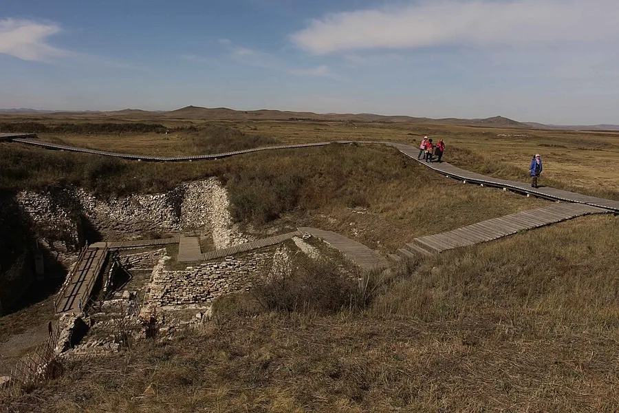 The ruins of Yuan Shangdu (Xanadu), Inner Mongolia.
Plan your visit
Getting there
Zhenglan Banner is about 190 km in a straight line from central Xilingol League. Search for 正蓝旗 in a map app to find stations and your accommodation.
Where to stay →Build your route
Start with Xanadu Ruins. The linked place guides have entrance and visit details.
Continue with Xilingol League →More in Xilingol League
Sources & geographic information
Administrative names and parent areas: Official geographic directory · Reference date 2026-09-06.
Some facts checked against 正蓝旗 (内蒙古) — Wikipedia contributors, CC BY-SA 4.0.
Some facts checked against 元上都 — Wikipedia contributors, CC BY-SA 4.0.
Photo: Xanadu Ruins · Flaumfeder · CC BY-SA 4.0. Proportionally resized and converted to WebP without cropping, retouching or changing the photographed subject.

Map data © OpenStreetMap contributors. Pins mark approximate centres, not entrances or boundaries.