


Get to know Chongchuan District
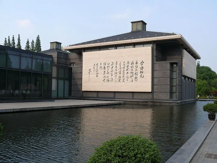
Photo adjustments
Full frame retained; proportionally resized and converted to WebP. No retouching or changes to the photographed subject. Card displays may crop the view.
- Administrative area
- District · 市辖区
- Part of
- Nantong
- Chinese name
- 崇川区
- Local areas
- District guide
History
A walled town was built here in 958, under the Later Zhou, and named Tongzhou (通州). In 1023, under the Song, it was renamed Chongzhou (崇州), also known as Chongchuan, the name the district carries today. After the 1911 revolution the prefecture became Nantong County. The present district took its shape in July 2020, when the old Chongchuan District and neighbouring Gangzha District (港闸区) were merged; the district government sits in Hongqiao Subdistrict (虹桥街道).
What to see
The Hao River scenic area is a national 4A site in the middle of the city: a moat of about 30 li (some 15 kilometres) that encircles the old town and is nicknamed "the jade necklace on a girl's neck". The district congress describes a cluster of museums around the river with the Nantong Museum (南通博物苑) at its core.
The Nantong Museum was founded by the industrialist and educator Zhang Jian (张謇) in January 1905 on the south side of the Hao River, and is widely counted as the first public museum set up independently by Chinese people. It was built as a garden and museum in one: the South Hall (1906) was the main exhibition building, the Middle Hall (1906) began as a weather station, and the North Hall (1911) was altered to display a whale skeleton dug up on the coast at Lüsi (吕四). A new hall opened in September 2005, and the site is a national key cultural relics protection unit.
Langshan, on the southern outskirts, rises to 106.94 metres and is the first of the "five hills of Langshan" (狼五山) with Ma'anshan (马鞍山), Jianshan (剑山), Junshan (军山) and Huangnishan (黄泥山). It is one of China's eight lesser Buddhist mountains and carries Guangjiao Temple (广教寺). The Langshan Church of Our Lady (狼山圣母堂) on its north side is an important Catholic church for northern Jiangsu, and papal decrees in the 1930s placed Langshan among twelve Catholic pilgrimage sites in China. On Jianshan lies the grave of a Dutch engineer who worked on Nantong's water control, rebuilt in 1987.
Setting and local products
The district lies on the flat Jianghai plain (江海平原) with the Yangtze on its west, Haimen District (海门区) to the south and Tongzhou District (通州区) to the east. Local products listed for the district include hard clams (文蛤), Reeves shad (鲥鱼) and yellow croaker (黄鱼). The district people's congress notes that Nantong West railway station is on the Shanghai–Suzhou–Nantong railway.
Highlights
- Nantong Museum 南通博物苑: Founded by Zhang Jian in 1905 as a combined garden and museum; a national key cultural relics protection unit.
- Hao River scenic area 濠河风景区: A national 4A moat of about 30 li that rings the old town.
- Langshan 狼山: 106.94-metre hill with Guangjiao Temple; one of China's eight lesser Buddhist mountains.
- Langshan Church of Our Lady 狼山圣母堂: Catholic church on the north side of Langshan, which papal decrees of the 1930s made one of twelve Catholic pilgrimage sites in China.
Sources for this guide
崇川区 - 维基百科,自由的百科全书 · Chinese Wikipedia · CC BY-SA 4.0
崇川区人大常委会关于全区全域旅游发展情况的审议意见 · Standing Committee of the Chongchuan District People's Congress
南通博物苑 - 维基百科,自由的百科全书 · Chinese Wikipedia · CC BY-SA 4.0
狼山 (江苏) - 维基百科,自由的百科全书 · Chinese Wikipedia · CC BY-SA 4.0
当地文化 · Nantong Vocational University
Original English written from the listed sources and checked sentence by sentence against quoted extracts by a separate reviewer. Updated 2026-09-25.
Explore Chongchuan District
Core places to explore, with English and Chinese names.
Places to explore around Chongchuan District
Nantong Museum building and reflecting pool · 南通博物苑馆舍与水池 Photograph date recorded by the source: 2 June 2010.Nantong Museum南通博物苑
Nantong Museum combines historic museum buildings with a garden beside the Haohe River. Founded by Zhang Jian, it presents both local history and natural-history material.
Read the place guide → Haohe River Scenic and Historic Spot · 濠河风景名胜区
Haohe River Scenic and Historic Spot濠河风景名胜区
The Haohe follows the moat around Nantong’s old city, creating a water circuit lined with gardens and cultural landmarks. Wenfeng Pagoda and Nantong Museum provide two contrasting stops: a vertical religious landmark and Zhang…
Read the place guide →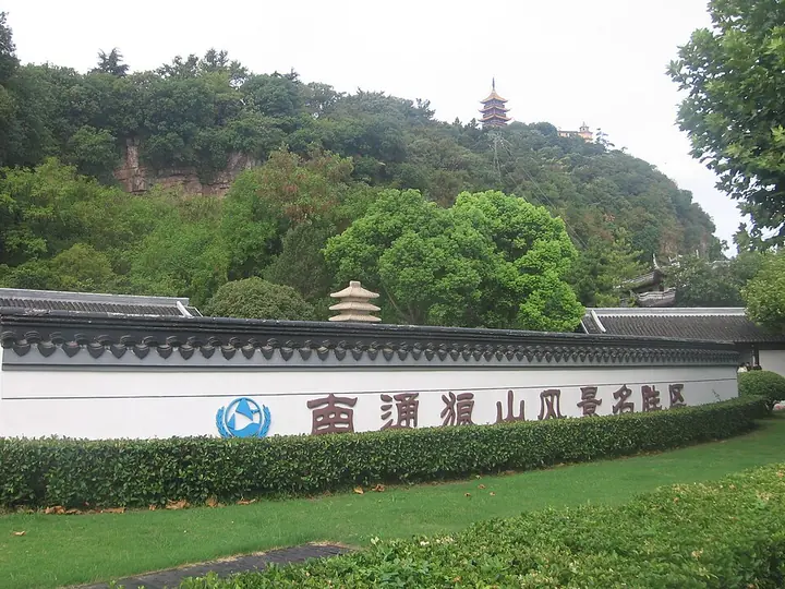 Langshan hillside and summit pagoda, Nantong · 南通狼山 Photograph date recorded by the source: 24 August 2022, 08:28:10.
Langshan (Nantong)狼山
Langshan, or Wolf Hill, stands in southern Nantong near the Yangtze. It belongs to a group of five hills that form a distinct landscape at the river’s lower reaches.
Read the place guide →Plan your visit
Getting there
Chongchuan District is about 5 km in a straight line from central Nantong. Search for 崇川区 in a map app to find stations and your accommodation.
Where to stay →Build your route
Nantong Museum and Haohe River Scenic and Historic Spot are about 35 km apart in a straight line. The linked place guides have entrance and visit details.
Continue with Nantong →More in Nantong
Sources & geographic information
Administrative names and parent areas: Official geographic directory · Reference date 2026-09-06.
Some facts checked against 崇川区 — Wikipedia contributors, CC BY-SA 4.0.
Some facts checked against 南通博物苑 — Wikipedia contributors, CC BY-SA 4.0.
Some facts checked against 狼山 (江苏) — Wikipedia contributors, CC BY-SA 4.0.
Photo: Nantong Museum · Peter Potrowl · © Peter Potrowl · CC BY 3.0. Full frame retained; proportionally resized and converted to WebP. No retouching or changes to the photographed subject. Card displays may crop the view.

Photo: Haohe River Scenic and Historic Spot · Source photographer · License not provided. EXIF orientation normalized; resized without changing aspect ratio; converted to WebP. No subject edits.
Photo: Langshan (Nantong) · Zhou Guanhuai · Zhou Guanhuai — Nantong_Langshan_Scenic_Spot_(Wolf_Hill).jpg — CC BY-SA 4.0 · CC BY-SA 4.0. Full frame retained; proportionally resized and converted to WebP. No retouching or changes to the photographed subject. Card displays may crop the view.
.jpg)
Map data © OpenStreetMap contributors. Pins mark approximate centres, not entrances or boundaries.