


Get to know Hai'an
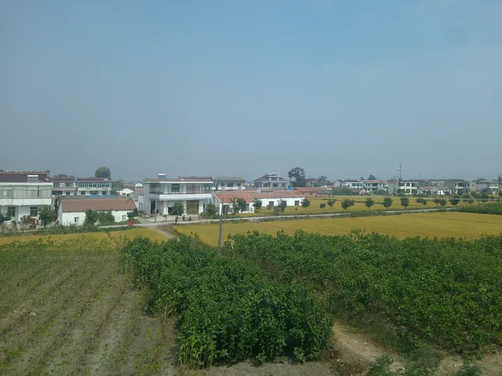
Photo adjustments
Full frame retained; proportionally resized and converted to WebP. No retouching or changes to the photographed subject. Card displays may crop the view.
- Administrative area
- County-level city · 县级市
- Part of
- Nantong
- Chinese name
- 海安市
- Local areas
- County-level city guide
Area & population
- Area in the source
- 1,180.00 km²
- Population · 2020 census
- 874,334
Source: cited geographic source, as of the dates shown.
Setting and landscape
The whole city is plain, crossed by dense waterways. The Tongyang Canal is the dividing line between two river systems: land south of it drains to the Yangtze, land north of it to the Huai. East of the Tongyang Canal and the Chuanchang River the ground is saline coastal plain laid down by the sea. North of the Tongyang Canal and west of the Chuanchang River lies the Lixiahe (里下河) water country.
History
The city government traces settlement back more than 6,000 years to Qingdun, in Qingdun village, Nanmo town (南莫镇). Found in 1973, it was the first Neolithic site discovered and excavated in the Nantong area; finds include stilt-built wooden houses and antlers of Père David's deer (麋鹿) carved with marks described as a 'primitive bagua' (eight trigrams). A site museum opened beside Huguo Temple (护国寺) in May 2019. Before the Qin the area was called Haiyang (海阳). A county was first set up here in 411, and in the Northern Song Fan Zhongyan (范仲淹) promoted the sea wall that runs through it.
What to see
Hai'an Museum, a national AAAA scenic area, combines a new museum building with the Former Residence of Han Guojun (韩国钧故居), the late-Qing house of a Republican-era governor of Jiangsu, listed as a national key heritage site in 2013. The Central Jiangsu Seven Victories Memorial Hall (苏中七战七捷纪念馆) was built in 1986. The Jianghuai Culture Park (江淮文化园) is a classical-style garden of more than 260 mu around a lake, and the Wei Jiangong Memorial Hall (魏建功纪念馆) presents Wei Jiangong's work on phonology and the promotion of Putonghua.
Food and local products
He Yingji buns (何盈记包子), made since 1910 and on Hai'an's intangible-heritage list since 2020, are best known in their crab-roe form. Glutinous-rice aged wine (糯米陈酒) dates from 1830, when Jiang Wenshu (蒋文枢) of Wuxi opened a sauce shop in Hai'an. Hai'an shrimp paste (麻虾酱) is made from sesame-sized freshwater mysid shrimp found only around Libao (李堡), and fish-soup noodles (鱼汤面), with a broth of small crucian carp and mixed fish, are the traditional breakfast of the Lixiahe villages.
Highlights
- Qingdun Site Museum 青墩遗址博物馆: Museum at the Neolithic Qingdun site in Nanmo town, opened in May 2019.
- Former Residence of Han Guojun 韩国钧故居: Late-Qing house of a Republican governor of Jiangsu; national key heritage site since 2013, part of Hai'an Museum.
- Central Jiangsu Seven Victories Memorial Hall 苏中七战七捷纪念馆: Memorial built in 1986.
- He Yingji buns 何盈记包子: Buns made since 1910; Hai'an intangible heritage, known for crab roe filling.
- Fish-soup noodles 鱼汤面: Lixiahe breakfast noodles in a broth of small crucian carp and mixed fish.
Sources for this guide
海安市 · Wikipedia (Chinese) · CC BY-SA 4.0
历史沿革 · Hai'an Municipal People's Government
旅游资源 · Hai'an Culture, Radio, Television and Tourism Bureau (Hai'an Municipal People's Government portal)
工艺特产 · Hai'an Culture, Radio, Television and Tourism Bureau (Hai'an Municipal People's Government portal)
青墩文化 · Hai'an Culture, Radio, Television and Tourism Bureau (Hai'an Municipal People's Government portal)
Original English written from the listed sources and checked sentence by sentence against quoted extracts by a separate reviewer. Updated 2026-09-25.
Explore Hai'an
Core places to explore, with English and Chinese names.
Plan your visit
Getting there
Hai'an is about 70 km in a straight line from central Nantong. Search for 海安市 in a map app to find stations and your accommodation.
Where to stay →More in Nantong
Sources & geographic information
Administrative names and parent areas: Official geographic directory · Reference date 2026-09-06.
Some facts checked against 海安市 — Wikipedia contributors, CC BY-SA 4.0.
Map data © OpenStreetMap contributors. Pins mark approximate centres, not entrances or boundaries.