


Get to know Shicheng County
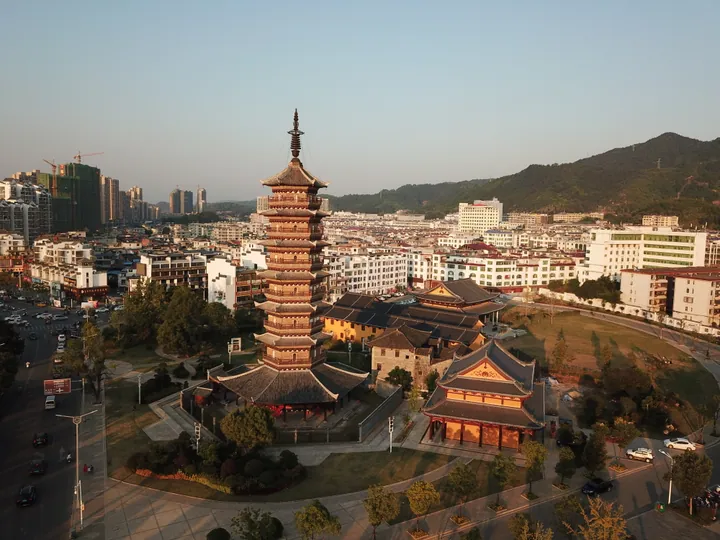
Photo adjustments
Full frame retained; proportionally resized and converted to WebP. No retouching or changes to the photographed subject. Card displays may crop the view.
- Administrative area
- County · 县
- Part of
- Ganzhou
- Chinese name
- 石城县
- Local areas
- County guide
Area & population
- Area in the source
- 1,581.53 km²
Source: cited geographic source, as of the dates shown.
Setting and landscape
The county takes its name from the rocky mountains that ring it and rise like city walls. Mountains close it in on the east, north and west, while the centre and southwest are lower, so the land tilts from northeast to southwest. The main ridge of the central Wuyi range runs along the eastern side and forms the natural barrier between Fujian and Jiangxi. The highest point is Jigongdong (鸡公岽), 1,389.9 metres, and the lowest lies at 173 metres in Dayou (大由乡). The Gan River begins at Shiliaodong (石寮岽) in Ganjiangyuan, and the Qinjiang River (琴江) crosses the county from north to south. Ninghua (宁化县) in Fujian lies east.
History
Shicheng was raised from an outpost to a county in 953 under the Southern Tang, and later belonged to Qianzhou, renamed Ganzhou in 1153. From 1754 it was placed under Ningdu. The Red Army first took the county on 27 June 1930, and in 1933 part of it was joined with neighbouring areas to form Tailei County (太雷县). The county government calls Shicheng a gateway on the route by which Hakka (客家) settlers moved east into western Fujian and south into eastern Guangdong.
What to see
Tongtianzhai (通天寨), a 4A scenic area in Qinjiang town (琴江镇) five kilometres southeast of the county town, is a Danxia landform area reaching 601.7 metres, a provincial forest park and Ganzhou's first provincial geopark. Its best-known cave, Tongtian Rock (通天岩), opens through a split in its roof to the sky, which gave the area its name. The county tourism bureau records that the geographer Huang Jin (黄进) of Sun Yat-sen University visited in November 1996 and found here, among more than 300 surveyed Danxia sites, the only such typical cracked rock-surface landform. Tea from the rock, especially Malan tea (马兰茶), was sent to the capital as tribute in the Ming and Qing periods.
Food, crafts and customs
The Shicheng lantern festival (石城灯会) has been on the national intangible-heritage list since 2008. In the local dialect "lantern" and "son" sound alike, and from the first day of the New Year until the Lantern Festival villagers carry dozens of kinds of paper-and-bamboo lanterns, among them dragons, lions, horses, vegetable baskets and carp, from house to house. Shicheng inkstone making (石城砚制作技艺), nationally listed in 2021, dates from the Northern Song; the stone comes from deep gorges and was once sent as tribute. White lotus covers about 5,700 hectares (86,000 mu). The county's heritage lists include Shicheng meatball making (石城肉丸), provincially listed, and hand-made rice noodles (石城手工米粉).
Highlights
- Tongtianzhai 通天寨: 4A Danxia landform scenic area and provincial geopark southeast of the county town, known for its cracked rock surfaces.
- Shicheng lantern festival 石城灯会: New Year lantern dances, on the national intangible-heritage list since 2008.
- Shicheng inkstone 石城砚: Inkstone craft dating from the Northern Song, nationally listed in 2021.
- Gan River source 赣江源: The Gan River rises at Shiliaodong in Ganjiangyuan township.
Sources for this guide
县情简介2026) | 石城县人民政府 · Shicheng County People's Government
灯会(石城灯会) - 中国非物质文化遗产网·中国非物质文化遗产数字博物馆 - 中国非物质文化遗产网非遗 · China Intangible Cultural Heritage Network (ihchina.cn)
石城通天寨 | 石城县人民政府 · Shicheng County Culture, Radio, TV, Press and Tourism Bureau (Shicheng County People's Government portal)
砚台制作技艺(石城砚制作技艺) - 中国非物质文化遗产网·中国非物质文化遗产数字博物馆 - 砚台制作技艺(石城砚制作技艺) · China Intangible Cultural Heritage Network (ihchina.cn)
石城县非物质文化遗产情况简介 | 石城县人民政府 · Shicheng County People's Government
Original English written from the listed sources and checked sentence by sentence against quoted extracts by a separate reviewer. Updated 2026-09-25.
Explore Shicheng County
Core places to explore, with English and Chinese names.
Places to explore around Shicheng County
 Tongtianzhai Scenic Area ·
 Local life & food
Shicheng County local specialties
石城县特色美食 · 1 specialties to discover
 Shicheng taro dumplings 石城芋饺AI dish illustration / AI 菜品示意图
A smooth, soft wrapper surrounds a more strongly seasoned filling. The contrast differs from an ordinary flour dumpling.
Source ↗Read the dish guide →All dish names · 全部菜名 (1)
More dishes from across Jiangxi are in the Jiangxi food guide.
Plan your visit
Getting there
Shicheng County is about 150 km in a straight line from central Ganzhou. Search for 石城县 in a map app to find stations and your accommodation.
Where to stay →Build your route
Start with Tongtianzhai Scenic Area. The linked place guides have entrance and visit details.
Continue with Ganzhou →More in Ganzhou
Sources & geographic information
Administrative names and parent areas: Official geographic directory · Reference date 2026-09-06.
Photo: Tongtianzhai Scenic Area · Sino Yu · CC BY-SA 4.0. EXIF orientation normalized; resized without changing aspect ratio; converted to WebP. No subject edits.

Map data © OpenStreetMap contributors. Pins mark approximate centres, not entrances or boundaries.