


Get to know Anyi County
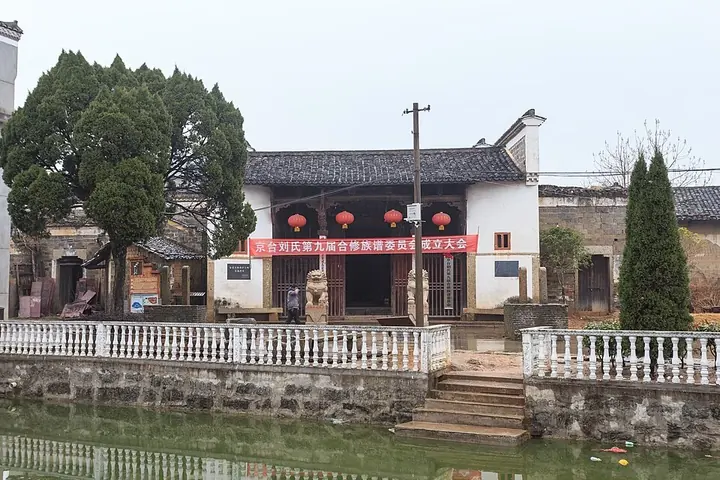
Photo adjustments
Full frame retained; proportionally resized and converted to WebP. No retouching or changes to the photographed subject. Card displays may crop the view.
- Administrative area
- County · 县
- Part of
- Nanchang
- Chinese name
- 安义县
- Local areas
- County guide
Area & population
- Area in the source
- 665.49 km²
- Population · 2018
- 306,500
Source: cited geographic source, as of the dates shown.
Setting and landscape
Anyi borders Xinjian District (新建区) of Nanchang to the east, Gao'an (高安) to the south, Fengxin (奉新) to the southwest, Jing'an (靖安) to the northwest and Yongxiu (永修) to the northeast. The county government sits in Longjin (龙津).
History
Chinese Wikipedia records human activity here 200,000 years ago. A short-lived Long'an County (龙安县) existed in the area in the early Tang before being absorbed by its neighbours. The county itself dates from the Ming: it took the name Anyi in 1518 and belonged to Nankang prefecture (南康府) through the Qing. After 1949 it was governed first from Nanchang and then from Yichun, and on 30 September 1983 the State Council placed it under Nanchang city.
What to see
The ancient village group links three villages, Luotian (罗田), Shuinan (水南) and Jingtai (京台); Luotian and Jingtai belong to Shibi town (石鼻镇). People's Daily's Jiangxi edition describes it as a typical village of Jiangxi (Gan) merchant culture, 1,400 years old, with more than 100 Ming and Qing houses, old streets, memorial archways, an opera stage and old trees. It is a national 4A scenic area and a China Historical and Cultural Village; Luotian was named one of the first Chinese Traditional Villages in 2012, and the whole group followed in 2013.
Several buildings are provincial protected monuments. The Shidafu mansion (世大夫第) in Luotian, built in 1762, faces west and covers 4,400 square metres across eleven buildings with carved interiors. Others are the Jingtai opera stage (京台戏台), Jingtai's Xilu (曦庐) house and Liu ancestral hall, and the Yuqingtang (余庆堂) house in Shuinan. Newer additions include a Gan-style snack street.
Getting oriented
National highways 353 and 354 pass through the county.
Highlights
- Anyi Ancient Village Group 安义古村群: Luotian, Shuinan and Jingtai villages with more than 100 Ming and Qing houses; national 4A.
- Luotian Shidafu Mansion 罗田世大夫第: Eleven-building mansion of 1762; provincial protected monument since 2006.
- Jingtai Opera Stage 京台戏台: Village opera stage listed as a Jiangxi provincial protected monument.
Sources for this guide
安义县 - 维基百科,自由的百科全书 · Wikipedia (Chinese) · CC BY-SA 4.0
江西安义:全域旅游“风”乍起 千年古村“潮”起来 · People's Daily Online, Jiangxi channel
石鼻镇 - 维基百科,自由的百科全书 · Wikipedia (Chinese) · CC BY-SA 4.0
罗田世大夫第 - 维基百科,自由的百科全书 · Wikipedia (Chinese) · CC BY-SA 4.0
安义县各级文物保护单位列表 - 维基百科,自由的百科全书 · Wikipedia (Chinese) · CC BY-SA 4.0
Original English written from the listed sources and checked sentence by sentence against quoted extracts by a separate reviewer. Updated 2026-09-25.
Explore Anyi County
Core places to explore, with English and Chinese names.
Anyi County 安义县
Plan your visit
Getting there
Anyi County is about 30 km in a straight line from central Nanchang. Search for 安义县 in a map app to find stations and your accommodation.
Where to stay →More in Nanchang
Sources & geographic information
Administrative names and parent areas: Official geographic directory · Reference date 2026-09-06.
Some facts checked against 安义县 — Wikipedia contributors, CC BY-SA 4.0.
Some facts checked against 石鼻镇 — Wikipedia contributors, CC BY-SA 4.0.
Some facts checked against 罗田世大夫第 — Wikipedia contributors, CC BY-SA 4.0.
Some facts checked against 安义县各级文物保护单位列表 — Wikipedia contributors, CC BY-SA 4.0.
Map data © OpenStreetMap contributors. Pins mark approximate centres, not entrances or boundaries.