


Get to know Sujiatun District
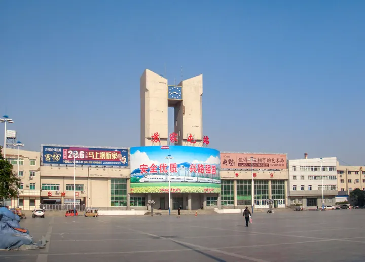
Photo adjustments
Full frame retained; proportionally resized and converted to WebP. No retouching or changes to the photographed subject. Card displays may crop the view.
- Administrative area
- District · 市辖区
- Part of
- Shenyang
- Chinese name
- 苏家屯区
- Local areas
- District guide
Area & population
- Area in the source
- 782.00 km²
- Population · 2020
- 524,336
Source: cited geographic source, as of the dates shown.
Setting and landscape
Xinhua describes the district as part of the Liaodong hill country, in the transition zone between the Liao (辽河) and Hun rivers, with low mountains in the east, hills in the middle and plain in the west. The climate is a warm-temperate, semi-humid monsoon climate with four clear seasons and around 2,500 hours of sunshine a year.
History and heritage
Several of Shenyang's municipal protected sites are in Sujiatun. Two monuments recall the Battle of Mukden (奉天会战) in the Russo-Japanese War: a monument to the Japanese Fourth Army on Yanlong Mountain (烟龙山) in Shahe (沙河), dated 1911, and a memorial to fallen Russian soldiers at Weijialou (魏家楼), dated 1912. Both were listed in 1985, together with a Han-dynasty site at Weijialouzi (魏家楼子).
The 2013 list added the remains of two walled settlements: Fengjipu (奉集堡) at Chenxiangtun (陈相屯), used in the Liao-Jin and Ming periods, and the Ming-era Hupiyi (虎皮驿) at Shilihe (十里河). Han sites at Ma'ershan (马耳山) and Xiaobaotun (小堡屯) in Yaoqianhutun (姚千户屯) were listed the same year.
Food and local products
Yongle grapes (永乐葡萄), from Yongle subdistrict (永乐街道), have been a national geographical-indication product since 2010. The variety is a seedless "white chicken heart" grape (无核白鸡心) bred in 1984 by growers in Yongle together with Shenyang Agricultural University (沈阳农业大学): large, long berries with thin skins, thick flesh and a sweet-sour taste. Xinhua describes one Huzhu (互助村) village grower's berries as weighing 8 to 12 grams and ripening yellow-green, crisp, with a hint of rose in the sweet-sour taste. Most are grown in Huzhu and Xiaohantai (小韩台村) villages, and growers across Yongle subdistrict also raise other varieties such as Shine Muscat (阳光玫瑰).
Highlights
- Yongle grapes 永乐葡萄: Seedless grape bred in Yongle in 1984; national geographical-indication product since 2010.
- Russian soldiers' memorial, Battle of Mukden 日俄奉天会战沙俄阵亡将士碑: 1912 memorial at Weijialou, a Shenyang municipal protected site since 1985.
- Fengjipu walled site 奉集堡城址: Liao-Jin and Ming walled settlement at Chenxiangtun, listed in 2013.
- Hupiyi walled site 虎皮驿城址: Ming-era walled site at Shilihe, listed in 2013.
Sources for this guide
苏家屯区 - 维基百科,自由的百科全书 · Wikipedia (Chinese) · CC BY-SA 4.0
从“绿藤”到“金串”:沈阳苏家屯“永乐葡萄”铺就富民路-新华网 · Xinhua
沈阳苏家屯区:《地理标志产品 永乐葡萄》市级地方标准正式发布-中新网辽宁频道 · China News Service, Liaoning
沈阳市文物保护单位 - 维基百科,自由的百科全书 · Wikipedia (Chinese) · CC BY-SA 4.0
Original English written from the listed sources and checked sentence by sentence against quoted extracts by a separate reviewer. Updated 2026-09-25.
Explore Sujiatun District
Core places to explore, with English and Chinese names.
Sujiatun District 苏家屯区
Plan your visit
Getting there
Sujiatun District is about 15 km in a straight line from central Shenyang. Search for 苏家屯区 in a map app to find stations and your accommodation.
Where to stay →More in Shenyang
Sources & geographic information
Administrative names and parent areas: Official geographic directory · Reference date 2026-09-06.
Some facts checked against 苏家屯区 — Wikipedia contributors, CC BY-SA 4.0.
Some facts checked against 沈阳市文物保护单位 — Wikipedia contributors, CC BY-SA 4.0.
Map data © OpenStreetMap contributors. Pins mark approximate centres, not entrances or boundaries.