


Get to know Heping District
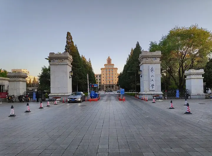
Photo adjustments
Full frame retained; proportionally resized and converted to WebP. No retouching or changes to the photographed subject. Card displays may crop the view.
- Administrative area
- District · 市辖区
- Part of
- Shenyang
- Chinese name
- 和平区
- Local areas
- District guide
Area & population
- Area in the source
- 60.00 km²
- Population · 2020
- 730,785
Source: cited geographic source, as of the dates shown.
Setting and landscape
Six rivers and canals run through the district, among them the Hun and the South Canal (南运河). The Taiyuan Street (太原街) shopping area is in Heping, and on the south bank of the Hun the district also takes in the Changbai Island (长白岛) and Heping Bay (和平湾) areas. Shenyang Railway Station, which the district government calls a hundred-year-old hub, stands inside Heping, and the consulates-general of seven countries, including the United States, North Korea and Russia, are based here.
History
According to a 2013 Shenyang Daily report on a new place-name gazetteer of the district, the site of today's Beishichang (北市场) was a Ming military fort called Bao'an (保安堡), on the official road towards Shanhaiguan; the fort is said to have had walls about one li round and more than 100 soldiers. Settlement grew after Hong Taiji (皇太极) ordered the Shisheng Temple (实胜寺) built west of the Small West Gate (小西门) in 1636, when craftsmen settled in a quarter known as the "Ten Rooms" (十间房).
In 1898 Russia took more than 10,700 mu of land in the west of today's district as railway land, and after the Russo-Japanese War it passed to Japan in 1905, becoming the Mukden railway zone. In 1938 the city administration of Manchukuo formed Yamato ward (大和区) out of the railway zone and the old commercial settlement. After Japan's surrender in 1945 Yamato was renamed Heping, meaning "peace".
What to see
The Shisheng Temple, a Qing imperial temple, still stands, as does what the district government describes as the only surviving ancestral temple of the Xibe (锡伯族) people. Zhongshan Road (中山路) is a protected historic block of century-old buildings. The Laobeishi (老北市) quarter at Beishichang is a national 4A scenic area and a national tourism and leisure street; Beishichang was once as famous as Beijing's Tianqiao (天桥), and the district government calls it a "living specimen" of Northeastern folk culture. It also credits the Huangsi temple fair (皇寺庙会) with nurturing the folk culture of the Northeast.
The Luyuan antiques market (鲁园古玩城) is one of the main antiques markets of Northeast China, and Xita Street (西塔街), the Korean-community quarter, was named Northeast China's first "international food street". Northeastern University (东北大学) and the Lu Xun Academy of Fine Arts (鲁迅美术学院) both have campuses in the district.
Highlights
- Shisheng Temple 实胜寺: Qing imperial temple ordered built by Hong Taiji in 1636 west of the Small West Gate.
- Laobeishi 老北市: National 4A scenic area and national tourism and leisure street on the site of the old Beishichang market.
- Zhongshan Road historic block 中山路历史文化街区: Street of century-old buildings whose conservation model was promoted nationally by the housing ministry.
- Xita Street 西塔街: Named Northeast China's first international food street.
Sources for this guide
区情简介-沈阳市和平区人民政府 · Heping District People's Government, Shenyang
沈阳老北市曾为明代一座军堡 驻守官兵百余人-中新网 · China News Service (reprinting Shenyang Daily)
和平区 (沈阳市) - 维基百科,自由的百科全书 · Wikipedia (Chinese) · CC BY-SA 4.0
Original English written from the listed sources and checked sentence by sentence against quoted extracts by a separate reviewer. Updated 2026-09-25.
Explore Heping District
Core places to explore, with English and Chinese names.
Heping District 和平区
Plan your visit
Getting there
Heping District is about 7 km in a straight line from central Shenyang. Search for 和平区 in a map app to find stations and your accommodation.
Where to stay →More in Shenyang
Sources & geographic information
Administrative names and parent areas: Official geographic directory · Reference date 2026-09-06.
Some facts checked against 和平区 (沈阳市) — Wikipedia contributors, CC BY-SA 4.0.
Map data © OpenStreetMap contributors. Pins mark approximate centres, not entrances or boundaries.