


Get to know Gangcheng District
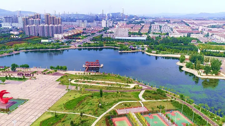
Photo adjustments
Full frame retained; proportionally resized and converted to WebP. No retouching or changes to the photographed subject. Card displays may crop the view.
- Administrative area
- District · 市辖区
- Part of
- Jinan
- Chinese name
- 钢城区
- Local areas
- District guide
Area & population
- Area in the source
- 507.00 km²
- Population · 2018
- 330,000
Source: cited geographic source, as of the dates shown.
Setting and landscape
The district government describes Gangcheng as lying at the source of the Wen River (汶水). The Dawen River (大汶河), which the government calls the largest tributary of the lower Yellow River, rises in Wenyuan Subdistrict (汶源街道); locally it is called the Mouwen River (牟汶河), and it flows roughly westward into Laiwu District (莱芜区). The government points out that the Wen is unusual in running from east to west. The highest peak is Xuangu (旋崮) at 732 metres, and Qishan National Forest Park (棋山国家森林公园) and the Jimushan forest farm (寄母山林场) are among its wooded areas. Traditional houses here are mostly built of stone.
History
In the Shang dynasty the state of Mou (牟国) had its capital at Zhaojiaquan village (赵家泉村), in today's Xinzhuang Subdistrict (辛庄街道). The district government traces bronze casting here to the Western Zhou and ironworking to the Spring and Autumn period. Sites include a Han-dynasty ironworks at Songjiazhuang (宋家庄冶铁遗址), a Tang mining and smelting site at Chaotieling (炒铁岭), the Yinshan (银山) mining site, the oldest tin mine found in the district, and a Tang tin smelting site at Xiye (西冶).
In the civil war, Chen Yi (陈毅), Su Yu (粟裕) and Tan Zhenlin (谭震林) directed the Laiwu Campaign (莱芜战役) from Shiwanzi village (石湾子村) in Xinzhuang. Construction of the Laiwu steel works began in the district in January 1970. Gangcheng became a district of Laiwu in 1993, and it was transferred to Jinan when Laiwu city was abolished in 2019.
Food and local products
The district's black pigs, black chickens and black goats carry national geographical-indication status, and the Laiwu pig and Laiwu black goat are national local breed resources. The district government also names Gangcheng a leading centre of rosewood furniture making north of the Yangtze.
Getting oriented
Gangcheng lies 132 km from central Jinan and 20 km from the seat of Laiwu District. It borders Xintai (新泰市) in Tai'an to the south and Yiyuan County (沂源县) in Zibo to the east. The Jinan-Laiwu high-speed railway (济莱高速铁路) stops at Gangcheng Station.
Highlights
- Source of the Dawen River 大汶河: The river rises in Wenyuan Subdistrict and flows west into Laiwu.
- Qishan National Forest Park 棋山国家森林公园: Named by the district government among its forested hills.
- Songjiazhuang ironworks site 宋家庄冶铁遗址: Han-dynasty ironworking site.
- Laiwu pig 莱芜猪: National local breed resource raised in the district.
Sources for this guide
钢城区 - 维基百科,自由的百科全书 · Wikipedia (Chinese) · CC BY-SA 4.0
钢城概况 - 济南市钢城区人民政府 · Gangcheng District People's Government, Jinan
史说钢城 - 济南市钢城区人民政府 · Gangcheng District People's Government, Jinan
Original English written from the listed sources and checked sentence by sentence against quoted extracts by a separate reviewer. Updated 2026-09-26.
Explore Gangcheng District
Core places to explore, with English and Chinese names.
Gangcheng District 钢城区
Plan your visit
Getting there
Gangcheng District is about 100 km in a straight line from central Jinan. Search for 钢城区 in a map app to find stations and your accommodation.
Where to stay →More in Jinan
Sources & geographic information
Administrative names and parent areas: Official geographic directory · Reference date 2026-09-06.
Some facts checked against 钢城区 — Wikipedia contributors, CC BY-SA 4.0.
Map data © OpenStreetMap contributors. Pins mark approximate centres, not entrances or boundaries.