


Get to know Laishan District
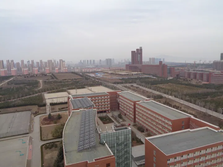
Photo adjustments
Full frame retained; proportionally resized and converted to WebP. No retouching or changes to the photographed subject. Card displays may crop the view.
- Administrative area
- District · 市辖区
- Part of
- Yantai
- Chinese name
- 莱山区
- Local areas
- District guide
Area & population
- Area in the source
- 258.00 km²
- Population · 2017
- 222,000
Source: cited geographic source, as of the dates shown.
Setting and landscape
Hills enclose the district to the north and south, and its eastern side runs along the Yellow Sea for about 10 kilometres of coast. Muping District (牟平区) borders it to the east and south, Fushan District (福山区) to the south-west and Zhifu to the north-west. The climate is warm-temperate and monsoonal, with cool summers and dry winters.
Besides being Yantai's administrative centre, the district is the city's science and education centre. Yantai University (烟台大学), Shandong Technology and Business University (山东工商学院), Binzhou Medical University (滨州医学院), Yantai Institute of Technology (烟台理工学院) and Yantai Culture and Tourism Vocational College (烟台文化旅游职业学院) are here, along with the Chinese Academy of Sciences' coastal zone research institute (中科院海岸带研究所).
What to see
Three of the district's sights stand on the seafront road, Binhai Middle Road (滨海中路). The Haichang Whale Shark Aquarium (海昌鲸鲨馆), housed in a nautilus-shaped building, is presented as the world's first ocean museum built around whale sharks, which swim in a 3,000-cubic-metre tank. The destroyer Hefei (合肥号), from China's first generation of home-designed guided-missile destroyers, sits beached at the Huanghai amusement park (黄海游乐城), where visitors can walk through its working and living quarters. The Huanghai Pearl (黄海明珠), a 30-metre glass-clad structure at the east end of the Huanghai pier (黄海栈桥), is a Yantai landmark lit at night by 1,180 lamps.
The Yantai University seaside beach (烟大国际海水浴场) runs for more than 10 kilometres of shore from Haiyun Square (海韵广场) to Tianyue Bay (天越湾). Fenghuang Pavilion (凤凰阁), a 24-metre, four-storey tower in Qing style, crowns Fenghuang Mountain (凤凰山), which has 3.5 kilometres of hiking trail and 800 metres of boardwalk. Shouxing Rock (寿星石), a natural boulder 40 metres high, looks over the whole Laishan coast; a 28.6-metre bronze God of Longevity riding a deer is built against it. Zhuque Mountain (朱雀山) forest park has more than 200 hectares of natural locust woods that flower in May, when a blossom festival is held.
Getting oriented
Yantai South station (烟台南站), on the high-speed network, is in the district, and the Qingdao–Yantai–Weihai–Rongcheng intercity railway (青烟威荣城际铁路) and the Rongcheng–Wuhai and Yantai–Haiyang expressways pass through it.
Highlights
- Haichang Whale Shark Aquarium 海昌鲸鲨馆: Nautilus-shaped ocean museum built around whale sharks in a 3,000-cubic-metre tank.
- Destroyer Hefei 合肥号驱逐舰: First-generation Chinese-designed guided-missile destroyer beached at the Huanghai amusement park.
- Huanghai Pearl 黄海明珠: 30-metre glass landmark at the east end of the Huanghai pier.
- Yantai University seaside beach 烟大国际海水浴场: More than 10 kilometres of shore from Haiyun Square to Tianyue Bay.
- Fenghuang Pavilion 凤凰阁: 24-metre Qing-style tower on Fenghuang Mountain.
- Shouxing Rock 寿星石: 40-metre natural boulder with a 28.6-metre bronze God of Longevity built against it.
Sources for this guide
莱山区概况 · Laishan District People's Government, Yantai
莱山必看景点 · Laishan District People's Government, Yantai
莱山区 - 维基百科,自由的百科全书 · Wikipedia (Chinese) · CC BY-SA 4.0
Original English written from the listed sources and checked sentence by sentence against quoted extracts by a separate reviewer. Updated 2026-09-23.
Explore Laishan District
Core places to explore, with English and Chinese names.
Laishan District 莱山区
Plan your visit
Getting there
Laishan District is about 5 km in a straight line from central Yantai. Search for 莱山区 in a map app to find stations and your accommodation.
Where to stay →More in Yantai
Sources & geographic information
Administrative names and parent areas: Official geographic directory · Reference date 2026-09-06.
Some facts checked against 莱山区 — Wikipedia contributors, CC BY-SA 4.0.
Map data © OpenStreetMap contributors. Pins mark approximate centres, not entrances or boundaries.