


Get to know Fanshi County
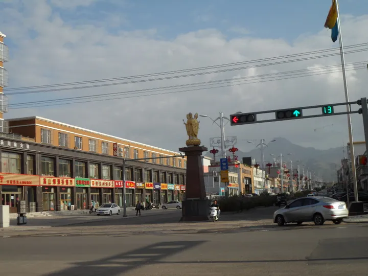
Photo adjustments
Full frame retained; proportionally resized and converted to WebP. No retouching or changes to the photographed subject. Card displays may crop the view.
- Administrative area
- County · 县
- Part of
- Xinzhou
- Chinese name
- 繁峙县
- Local areas
- County guide
Area & population
- Population · 2020
- 250,409
Source: cited geographic source, as of the dates shown.
History
In the Spring and Autumn period the area was the town of Huoren (霍人) in the state of Jin; the Western Han set up Lucheng County (卤城县) here, and the Western Jin re-established Fanshi County. In 1215 the Jin dynasty raised it to Jianzhou prefecture (坚州), and in 1369 the Ming turned it back into Fanshi County.
On 25 September 1937 the Battle of Pingxingguan (平型关战役) was fought in the county. On 7 April 1948 Mao Zedong, travelling from Yan'an to Xibaipo (西柏坡), stayed in Boqiang village (伯强村).
What to see
Yanshan Temple (岩山寺), first called Lingyan Temple (灵岩寺), sits at the northern foot of Wutai Shan about 40 kilometres from the county town. Founded in 1158 under the Jin dynasty, it is a national key cultural relics protection site. Its south hall, the Manjushri Hall (文殊殿), holds murals by the court painter Wang Kui (王逵), begun in 1167 and ten years in the making. The west wall shows the life of Shakyamuni, the south wall five hundred shipwrecked merchants saved by a rakshasi, and the east wall city life of the Song and Jin period.
Gongzhu Temple (公主寺), 15 kilometres southeast of the county town, takes its name from a Northern Wei princess said to have become a nun here. Its passage hall, a Ming building, keeps more than 200 square metres of Ming murals and over 30 painted statues. The county pairs these murals with those of Yongle Palace (永乐宫) as the "two pearls of north and south" (南北双珠). The temple was added to the sixth list of national key sites in May 2006.
In the county town, the Hutuo Source scenic area (滹源景区) is a waterside park rated national 4A in 2018; it takes in Zhengjue Temple (正觉寺), a national key site, and the drum tower.
Food and local products
Fanshi tofu (繁峙豆腐), locally called "water tofu" (水豆腐), is made from yellow or black soybeans that are soaked, ground to milk, set with brine and pressed into tender tofu. A local story has a Fanshi family serving home-style braised tofu to the Kangxi Emperor when he passed through on a trip to Wutai Shan. Around 40 households from Nanguan village (南关村) have taken the craft to Beijing, Inner Mongolia and other cities. The county also holds the title of China's home of broomcorn millet.
Highlights
- Yanshan Temple 岩山寺: Jin-dynasty temple founded in 1158; its Manjushri Hall murals were painted by the court painter Wang Kui from 1167.
- Gongzhu Temple 公主寺: Temple whose Ming passage hall keeps over 200 square metres of murals; national key site since 2006.
- Hutuo Source scenic area 滹源景区: 4A waterside park in the county town that includes Zhengjue Temple.
- Fanshi tofu 繁峙豆腐: Soft brine-set "water tofu" made from yellow or black soybeans.
Sources for this guide
繁峙概况 · Fanshi County People's Government
历史沿革 · Fanshi County People's Government
繁峙县岩山寺 · Fanshi County People's Government
滹源国家AAAA级景区 · Fanshi County People's Government
繁峙县公主寺 · Fanshi County People's Government
繁峙豆腐 · Fanshi County People's Government
Original English written from the listed sources and checked sentence by sentence against quoted extracts by a separate reviewer. Updated 2026-09-26.
Explore Fanshi County
Core places to explore, with English and Chinese names.
Fanshi County 繁峙县
Plan your visit
Getting there
Fanshi County is about 100 km in a straight line from central Xinzhou. Search for 繁峙县 in a map app to find stations and your accommodation.
Where to stay →More in Xinzhou
Sources & geographic information
Administrative names and parent areas: Official geographic directory · Reference date 2026-09-06.
Map data © OpenStreetMap contributors. Pins mark approximate centres, not entrances or boundaries.