


Get to know Taibao City
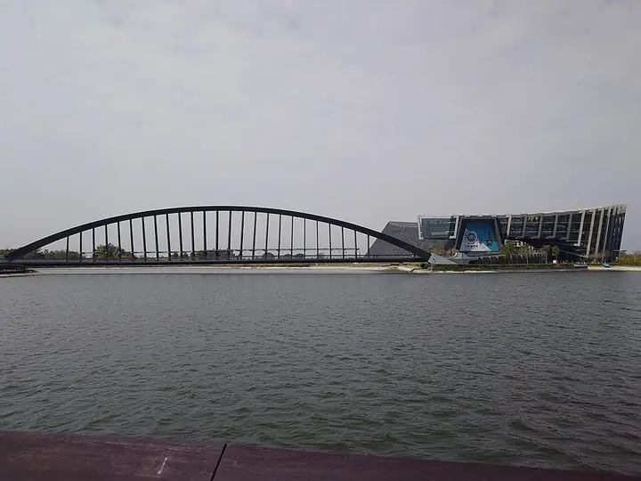
Photo adjustments
Full-frame source proportionally resized and converted to WebP for display. No subject alteration. Source-supplied marks and edits remain; cards may crop the view.
- Administrative area
- County-administered city · 市
- Part of
- Chiayi County
- Chinese name
- 太保市
- Local areas
- County-administered city guide
Area & population
- Area in the source
- 66.90 km²
Source: cited geographic source, as of the dates shown.
A museum with an Asian perspective
The museum presents objects from the National Palace Museum collection within an Asian cultural framework. Architect Kris Yao (姚仁喜) translated three ink-painting techniques into its design: dense ink, flying-white brushwork and washes. The glazed eastern Feibai Hall (飛白館) contrasts with the more enclosed western Moyun Building (墨韻樓), which contains exhibition and collection-storage spaces.
Bridge and lakes
Zhimei Bridge (至美橋) crosses the artificial lake south of the main building. Its 141-metre single arch avoids placing piers in the lake, protecting the waterproofing below. The bridge’s design echoes cursive calligraphy. The grounds’ artificial lakes also serve flood-control functions, alongside their role in the landscaped park.
Sources for this guide
故宮博物院-南部院區 | 雲嘉南濱海國家風景區 · Southwest Coast National Scenic Area Administration
國立故宮博物院南部院區 平衡南北、文化均富 - 台灣光華雜誌 · Taiwan Panorama, Ministry of Foreign Affairs
Original English written from the listed sources and checked sentence by sentence against quoted extracts by a separate reviewer. Updated 2026-09-27.
Explore Taibao City
Core places to explore, with English and Chinese names.
Places to explore around Taibao City
Plan your visit
Getting there
Taibao City is about 30 km in a straight line from central Chiayi County. Search for 太保市 in a map app to find stations and your accommodation.
Where to stay →Build your route
Start with Southern Branch of the National Palace Museum. The linked place guides have entrance and visit details.
Continue with Chiayi County →More in Chiayi County
Sources & geographic information
Administrative names and parent areas: Official geographic directory · Reference date 2026-09-06.
Photo: Southern Branch of the National Palace Museum · S8321414 · CC BY-SA 4.0. Full-frame source proportionally resized and converted to WebP for display. No subject alteration. Source-supplied marks and edits remain; cards may crop the view.

Map data © OpenStreetMap contributors. Pins mark approximate centres, not entrances or boundaries.