


Get to know Piqan County
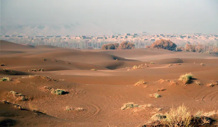
Photo adjustments
Full frame retained; proportionally resized and converted to WebP. No retouching or changes to the photographed subject. Card displays may crop the view.
- Administrative area
- County · 县
- Part of
- Turpan
- Chinese name
- 鄯善县
- Local areas
- County guide
Area & population
- Area in the source
- 39,550.00 km²
- Population · 2020
- 242,310
- Administrative seat
- Shanshan Town
Source: cited geographic source, as of the dates shown.
Dunes beside the urban area
The Kumtag Desert meets the built-up area of Piqan. Its varied sand formations include crescent dunes, pyramid-shaped dunes, linear dune chains, compound sand ridges and flat sandy ground. The Xinjiang Department of Natural Resources (新疆维吾尔自治区自然资源厅) explains their formation through wind transporting thick Quaternary sediments towards the county.
Manuscripts and cave temples
The Tuyugou Caves (吐峪沟石窟), formerly called Dinggu Temple (丁谷寺), began in the fifth century and remained in use into the Five Dynasties and Song periods. The surviving complex comprises 157 caves, three ground-level temples and nine pagodas. Finds include Buddhist scriptures in Chinese, Old Uyghur and Sogdian, alongside Daoist and Manichaean manuscripts. Tuyugou Village (吐峪沟村) also preserves Uyghur traditions; its tourism programme includes song, dance and traditional sports.
Sources for this guide
自治区地质遗迹名录(第一批)地质遗迹说明_重要地质遗迹_新疆维吾尔自治区自然资源厅 · Xinjiang Department of Natural Resources
吐峪沟石窟5月1日起对外正式开放 · Turpan Media Centre, republished by Piqan County Government
鄯善县吐峪沟景区1-6月接待游客创新高,文旅融合成发展新引擎 · Piqan County Media Centre
Original English written from the listed sources and checked sentence by sentence against quoted extracts by a separate reviewer. Updated 2026-09-27.
Explore Piqan County
Core places to explore, with English and Chinese names.
Places to explore around Piqan County
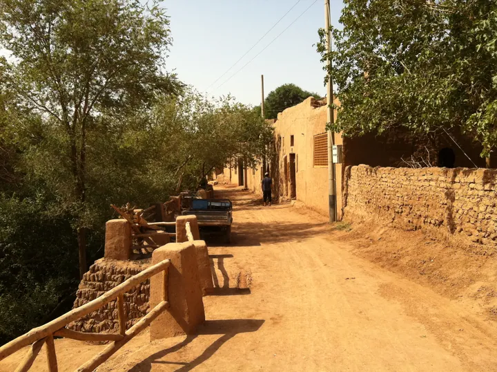 A street in Mazha Village, Tuyoq, lined with mudbrick houses · 吐峪沟麻扎村内的生土建筑街巷 Source-recorded photograph date: Taken on 13 July 2011.
Tuyugou Mazar Village吐峪沟麻扎村
Uyghur village of yellow-clay houses at the mouth of the Tuyugou gorge in Turpan, below the Ashab al-Kahf shrine.
Read the place guide → Dunes in the Shanshan-side Kumtag Desert visitor landscape, Xinjiang · 新疆鄯善库木塔格沙漠沙丘. Source-recorded photograph date: Taken on 28 September 2009.
Kumtag Desert库木塔格沙漠
Kumtag Desert (库木塔格沙漠) is the desert on the eastern edge of the Turpan basin, in Shanshan County (鄯善县), Turpan (吐鲁番市), Xinjiang. It is both a national desert park and a 4A-grade scenic area.
Read the place guide →Plan your visit
Getting there
Piqan County is about 85 km in a straight line from central Turpan. Search for 鄯善县 in a map app to find stations and your accommodation.
Where to stay →Build your route
Tuyugou Mazar Village and Kumtag Desert are both listed here. The linked place guides have entrance and visit details.
Continue with Turpan →More in Turpan
Sources & geographic information
Administrative names and parent areas: Official geographic directory · Reference date 2026-09-06.
Photo: Tuyugou Mazar Village · Matthew Summerton · CC BY-SA 3.0. Full frame retained; proportionally resized and converted to WebP. No retouching or changes to the photographed subject. Card displays may crop the view.
.jpg)
Photo: Kumtag Desert · 罗布泊 · CC BY 3.0. Full source framing retained; proportionally resized and converted to WebP. No retouching or subject alteration. Card displays may crop the view.
.jpg)
Map data © OpenStreetMap contributors. Pins mark approximate centres, not entrances or boundaries.