


Get to know Longyang District
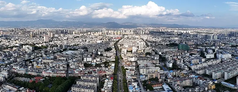
Photo adjustments
Full frame retained; proportionally resized and converted to WebP. No retouching or changes to the photographed subject. Card displays may crop the view.
- Administrative area
- District · 市辖区
- Part of
- Baoshan
- Chinese name
- 隆阳区
- Local areas
- District guide
Area & population
- Area in the source
- 5,011.00 km²
- Population · 2020 census
- 903,081
Source: cited geographic source, as of the dates shown.
Setting and landscape
The Gaoligong Mountains (高黎贡山) cross the district, which makes it part of a national nature reserve, a world biosphere reserve and the Three Parallel Rivers world natural heritage site. Heights range from 648 to 3,659.6 metres, and the Baoshan basin (保山坝), at 149.9 square kilometres, is the largest area of flat land. The district government sums up the climate as "four seasons on one mountain", with an annual mean of 16.8°C. Lujiang (潞江镇) lies at the lower end of the Nu River gorge, where the river opens into the largest flat valley floor of the canyon.
History
Under the Zhou the area was the chief town of the Ailao kingdom (哀牢国). Yongchang Commandery (永昌郡) was set up here in AD 69, and the name Baoshan dates from 1524, when Baoshan County was created. The district was a key point on the ancient Shu–Shendu road (蜀身毒道) to India and on the Southern Silk Road, and the Burma Road (滇缅公路), the wartime international supply line, runs through it. Baoshan County became a county-level city in 1983 and was reorganised as Longyang District in 2000.
What to see
In the city centre are Taibao Mountain Forest Park (太保山森林公园), Yiluo Pool (易罗池) and Renshou Gate (仁寿门), which the district government calls the only surviving old city gate of Baoshan. Qinghua Lake (青华海) is described as the largest open park in the district. National protected sites include the Hanzhuang walled-town site (汉庄城址), Guangzun Temple (光尊寺) and the Guanpo ancient post road (官坡古驿道) at Banqiao (板桥镇), and two more stretches of old post road at Puxiao (蒲缥镇): Lengshuiqing (冷水箐古驿道) and Panshegu (盘蛇谷古驿道). Baihualing (百花岭) village in Mangkuan (芒宽), in the gorge between the Gaoligong and Nu mountains, is known for birdwatching.
Food and local products
Lujiang is the district's "coffee valley", growing Baoshan small-bean coffee (保山小粒咖啡), a national geographical-indication product, alongside mangoes and dragon fruit. The Baoshan touxinlu bean (透心绿) is a small local broad bean whose white skin hides a bright green kernel; it is roasted into a snack called paochaodou (泡炒豆). Baoshan agate carving (保山玛瑙雕刻) is on the provincial intangible heritage list, and Lancheng (兰城街道) is a centre for carving and trading the stone. Wutong zouyin (乌铜走银, literally "silver running on black copper") is another provincial heritage craft.
Highlights
- Renshou Gate 仁寿门: The only surviving old city gate of Baoshan, according to the district government.
- Qinghua Lake 青华海: Described by the district government as the largest open park in the district.
- Hanzhuang walled-town site 汉庄城址: Major Historical and Cultural Site Protected at the National Level.
- Guanpo ancient post road 官坡古驿道: National protected stretch of old road at Banqiao.
- Baoshan small-bean coffee 保山小粒咖啡: Geographical-indication coffee grown in the Lujiang valley.
- Baoshan agate carving 保山玛瑙雕刻: Provincial intangible heritage; Lancheng is a carving and trading centre.
Sources for this guide
区情-隆阳区人民政府门户网站 · Longyang District People's Government, Baoshan
隆阳区 - 维基百科,自由的百科全书 · Chinese Wikipedia · CC BY-SA 4.0
Original English written from the listed sources and checked sentence by sentence against quoted extracts by a separate reviewer. Updated 2026-09-25.
Explore Longyang District
Core places to explore, with English and Chinese names.
Places to explore around Longyang District
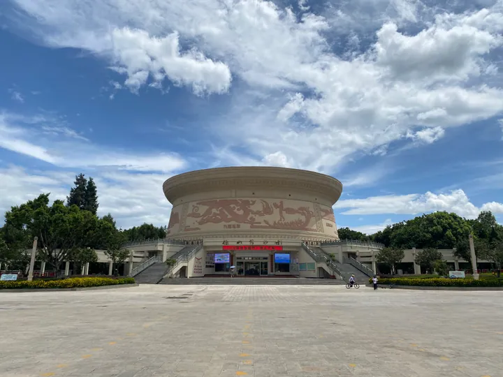 Exterior of Baoshan Museum, Longyang District · 保山博物馆外观,隆阳区 Source-recorded photograph date: 2023-07-25 15:13:06.
Baoshan Museum保山博物馆
Baoshan's city museum in a bronze-drum-shaped building, with galleries on the Ailao kingdom, Yongchang history and the war years.
Read the place guide →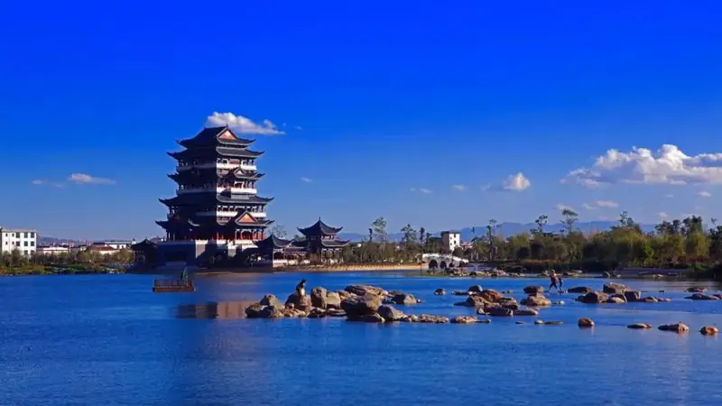 Qinghuahai Wetland · 青华海湿地
Qinghuahai Wetland青华海湿地
Qinghua Hai National Wetland Park lies in the eastern urban district of Longyang district, Baoshan, covering 1,363 hectares of lake, reservoir ponds, river, marsh and forest habitat. A causeway running north to south divides the water into West Lake and East Lake; the name Qinghua was given by the Ming-dynasty scholar Yang Shen, exiled to Yongchang, who was captivated by the lake's beauty.
Read the place guide →Local life & food
Longyang District local specialties
隆阳区特色美食 · 1 specialties to discover
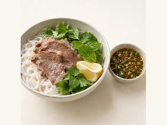 Dai-style lemon sa with rice noodles 傣味柠檬撒AI dish illustration / AI 菜品示意图
Expect a sharp citrus taste, fresh herbs and chilli, with soft noodles carrying the dressing. The mixture can be intense, so a little dip may season more noodles than its small bowl suggests.
Source ↗Read the dish guide →All dish names · 全部菜名 (1)
More dishes from across Yunnan are in the Yunnan food guide.
Plan your visit
Getting there
Longyang District covers the centre of Baoshan. Search for 隆阳区 in a map app to find stations and your accommodation.
Where to stay →Build your route
Baoshan Museum and Qinghuahai Wetland are both listed here. The linked place guides have entrance and visit details.
Continue with Baoshan →More in Baoshan
Sources & geographic information
Administrative names and parent areas: Official geographic directory · Reference date 2026-09-06.
Some facts checked against 隆阳区 — Wikipedia contributors, CC BY-SA 4.0.
Photo: Baoshan Museum · 瑞丽江的河水 · CC BY-SA 4.0. Full frame retained; proportionally resized and converted to WebP. No retouching or changes to the photographed subject. Card displays may crop the view.

Photo: Qinghuahai Wetland · Source photographer · License not provided. EXIF orientation normalized; resized without changing aspect ratio; converted to WebP. No subject edits.
Map data © OpenStreetMap contributors. Pins mark approximate centres, not entrances or boundaries.