


Get to know Jiuquan
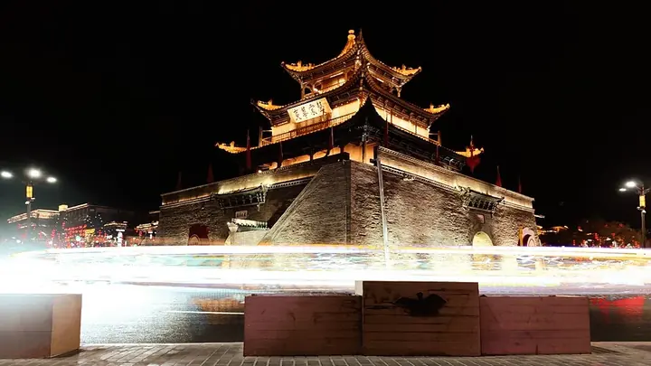
Photo adjustments
Full frame retained; proportionally resized and converted to WebP. No retouching or changes to the photographed subject. Card displays may crop the view.
- Administrative area
- Prefecture-level city · 地级市
- Part of
- Gansu
- Chinese name
- 酒泉市
- Local areas
- 7 local areas
Area & population
- Area in the source
- 167,883.00 km²
- Population · 2022
- 1,053,100
- Administrative seat
- Suzhou District
Source: cited geographic source, as of the dates shown.
Setting and landscape
The land falls from south to north. Snow and glaciers cap the Qilian range above about 4,500 m, and the city government gives Tuanjie Peak (团结峰, 5,808 m) as the highest point. The Shule (疏勒河), Hei (黑河) and Suganhu (苏干湖) drainage systems rise in the Qilian and Altun snowfields, and the Dang River (党河) flows down to Dunhuang. The climate is arid and continental; Guazhou (瓜州) is nicknamed the 'world's wind storehouse'.
History
The city government says Jiuquan, 'wine spring', is named for a spring below the town whose water was like wine. After Huo Qubing (霍去病) marched into the Hexi in 121 BC, the Han set up Jiuquan Commandery, seated at Lufu (禄福) in today's Suzhou District (肃州区), as one of the four Hexi commanderies. The town became Suzhou prefecture in 602. The city government also calls Jiuquan the cradle of China's modern spaceflight and the birthplace of its oil and nuclear industries; the present prefecture-level city dates from 2002.
What to see
The Mogao Caves (莫高窟), cut into the eastern cliff of Mingsha Mountain (鸣沙山) 25 km southeast of Dunhuang, were begun in 366 and keep 735 caves dating from the Northern Wei to the Yuan; they were inscribed as World Heritage in 1987, and their Library Cave was discovered in 1900. Dunhuang also has Mingsha Mountain and Crescent Lake (月牙泉), the Dunhuang Yardang National Geopark (敦煌雅丹国家地质公园) and the two Han passes, Yang Pass (阳关) and Yumen Pass (玉门关).
In Guazhou, Suoyang City (锁阳城), built under the Han and flourishing under the Tang, is named after the suoyang herb that grows there; it was abandoned in 1524 when the Jiayu Pass closed and joined the Silk Roads World Heritage listing in 2014. Jinta County (金塔县) has a forest of Euphrates poplars (金塔胡杨林).
Food and local products
Dunhuang's Li Guang apricots (李广杏), golden and smooth-skinned, became a national geographical indication product in December 2016; their skins are boiled with hawthorn, goji and rock sugar into apricot-skin drink (杏皮水), a Dunhuang intangible heritage item. Donkey-meat yellow noodles (驴肉黄面) are tossed noodles topped with diced donkey meat, soft tofu and mushrooms, and huyang menbing (胡羊焖饼) braises mutton with flatbread.
Getting oriented
The municipal government building is in Suzhou District. The Lanzhou–Xinjiang railway and its second double-track line cross the prefecture, and the Dunhuang–Golmud line runs south into Qinghai. The Jiuquan Satellite Launch Center, which straddles Jinta County and Inner Mongolia's Ejin Banner, takes its name from the city.
Highlights
- Mogao Caves 莫高窟: The monk Le Zun (乐僔) cut the first cave in 366; the Library Cave held manuscripts in Chinese, Tibetan, Sanskrit, Sogdian and other scripts.
- Suoyang City 锁阳城: Han-to-Tang walled town in Suoyangcheng Town (锁阳城镇), Guazhou; the site also includes old river channels, temples, tombs and farmland.
- Li Guang apricot 李广杏: Grown mainly in Yueyaquan Town (月牙泉镇) below Mingsha Mountain; Heshui Village (合水村) is its place of origin.
- Suoyang herb 锁阳: A Gobi plant used in Chinese medicine, mostly parasitic on the roots of nitraria shrubs.
Sources for this guide
历史沿革 - 酒泉市人民政府 · Jiuquan Municipal People's Government
酒泉概况 - 酒泉市人民政府 · Jiuquan Municipal People's Government
酒泉市 - 维基百科,自由的百科全书 · Wikipedia (Chinese) · CC BY-SA 4.0
莫高窟 - 维基百科,自由的百科全书 · Wikipedia (Chinese) · CC BY-SA 4.0
锁阳城遗址 - 维基百科,自由的百科全书 · Wikipedia (Chinese) · CC BY-SA 4.0
【家乡的味道】 敦煌李广杏 丝路古郡的千年果香_古风民俗_中国甘肃网 · Gansu Daily (China Gansu Net)
Original English written from the listed sources and checked sentence by sentence against quoted extracts by a separate reviewer. Updated 2026-09-30.
Explore Jiuquan
Core places to explore, with English and Chinese names.
Mogao Caves 莫高窟
Crescent Lake · Mingsha Mountain dunes 鸣沙山月牙泉·月牙泉示意点
Yumen Pass 玉门关
Yang Pass 阳关
Yulin Caves 榆林窟
Suoyang City 锁阳城
Dunhuang 敦煌
Western Han Jiuquan Scenic Park 西汉酒泉胜迹
Boluo Zhuanjing Film Location 博罗转井影视基地
Dunhuang Museum 敦煌博物馆
Dunhuang Historical Film City 敦煌古城影视城
Dunhuang Yardang National Geopark 敦煌雅丹国家地质公园
Yumen Pass Ruins 玉门关遗址
Western Thousand Buddha Caves 西千佛洞
Yangguan Pass Ruins 阳关遗址
Mingsha Mountain and Crescent Moon Spring 鸣沙山月牙泉
Yumen Oilfield Industrial Heritage 玉门油田工业遗产
Suoyang City Ruins 锁阳城遗址
Son of the Earth Sculpture 大地之子
Touming Mengke Glacier Viewing Route 透明梦柯冰川开放观景线路
Jiuquan Shengji Garden 酒泉胜迹
Jinta Desert Poplar Forest 金塔沙漠胡杨林
Aksay Old County Town Ruins 阿克塞老县城
Suzhou District 肃州区
Jinta County 金塔县
Guazhou 瓜州县
Subei Mongol Autonomous County 肃北蒙古族自治县
Aksay Kazak Autonomous County 阿克塞哈萨克族自治县
Yumen 玉门市
Dunhuang 敦煌市
Places to explore around Jiuquan
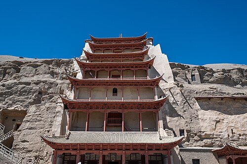 Mogao Caves · 莫高窟
Mogao Caves莫高窟
Mogao’s cliff contains a long sequence of Buddhist caves in which murals, painted sculpture and architecture work together. Narrative paintings share walls with donors and repeated Buddha figures, while changing styles reflect…
Read the place guide →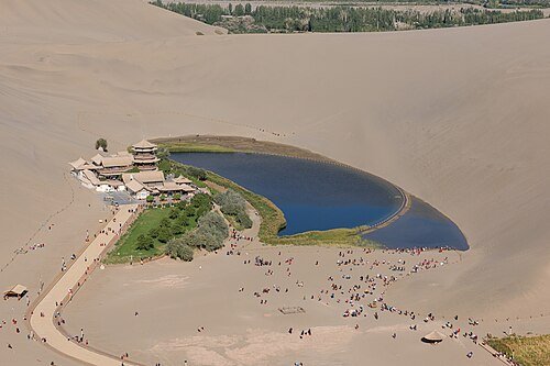 Crescent Lake among the Mingsha dunes near Dunhuang.
Crescent Lake · Mingsha Mountain dunes鸣沙山月牙泉·月牙泉示意点
Crescent Lake is a small curved oasis enclosed by the much larger dunes of Mingsha Mountain. The contrast between water, vegetation and bare sand is the main attraction, with the outline changing as you move between the lakeside…
Read the place guide →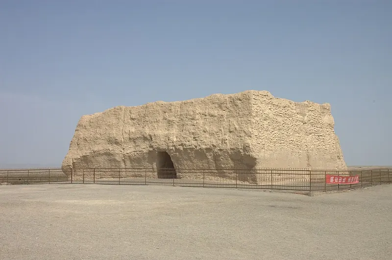 Rammed-earth remains at Yumen Pass · 玉门关小方城遗址 Photograph date recorded by the source: 2011-09.
Yumen Pass玉门关
Yumen Pass survives as a compact, square earthen stronghold known as Xiaofangpan Cheng. Its thick walls and small openings make a striking object in the open desert, but the wider heritage area tells a larger story of frontier…
Read the place guide → Beacon ruins at Yang Pass · 阳关 Photograph date recorded by the source: 2011-09.
Yang Pass阳关
Yang Pass marked a southern departure from the Dunhuang oasis into the desert routes of the Silk Road. The old fortified gateway has not survived as an intact gate: the beacon on Dundun Mountain and the surrounding desert are…
Read the place guide →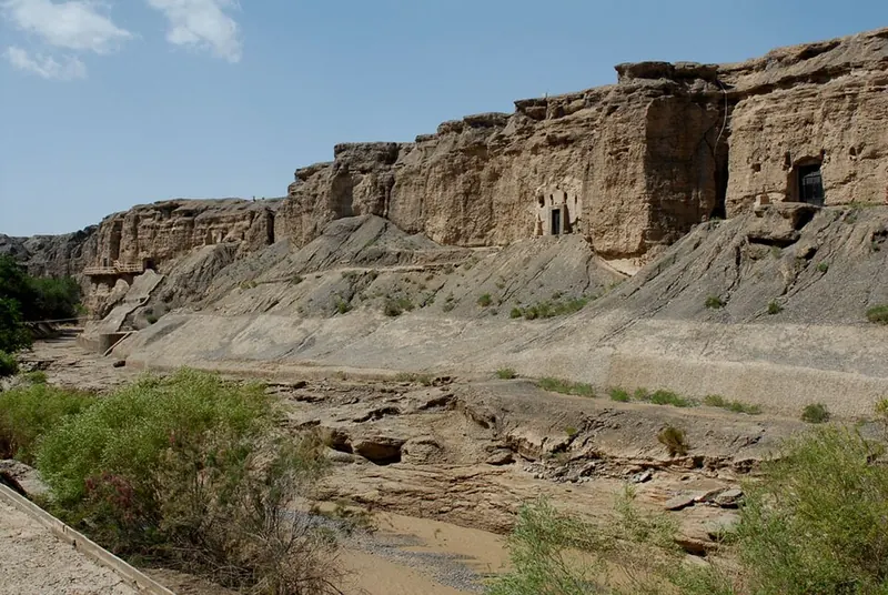 The cliff face and cave openings at Yulin Caves. Photograph date recorded by the source: 2012-06-17 11:23:43.
Yulin Caves榆林窟
Yulin’s caves occupy opposing cliffs along an elm-lined river gorge south of Guazhou. Their murals and painted figures belong to the same broad artistic world as Dunhuang, yet the narrow river setting gives the complex a…
Read the place guide → Earthen wall remains at Suoyang City. Photograph date recorded by the source: 2016-08-05 18:01:36.
Suoyang City锁阳城
Suoyang is the remains of an oasis settlement whose earth walls stand amid a much wider archaeological landscape. The inner and outer city, religious remains and traces of former water management show that frontier life depended…
Read the place guide → The nine-storey facade at Mogao Cave 96, Dunhuang · 敦煌莫高窟九层楼 Photograph date recorded by the source: 10 October 2015.
Dunhuang敦煌
Dunhuang is an oasis whose visitor routes connect Buddhist cave art, desert water and the remains of frontier travel. Mogao introduces the paintings and sculpture supported by the Silk Road’s changing communities. Crescent Lake…
Read the place guide → Western Han Jiuquan Scenic Park · 西汉酒泉胜迹
Western Han Jiuquan Scenic Park西汉酒泉胜迹
Western Han Jiuquan Scenic Park gathers a spring, lake and garden buildings around the story behind Jiuquan’s name. Tradition says the general Huo Qubing shared an imperial gift of wine by pouring it into the spring for his…
Read the place guide → Boluo Zhuanjing Film Location · 博罗转井影视基地
Boluo Zhuanjing Film Location博罗转井影视基地
Boluo Zhuanjing was Aksai’s former county seat before its abandoned streets became a film location. Surviving public buildings, including a theatre, school and hospital, provide the real town fabric behind its cinematic…
Read the place guide → A painted mural of Buddhist figures and pavilions on display at Dunhuang Museum · 敦煌博物馆内展出的佛教人物楼阁壁画 Source-recorded photograph date: 8 November 2015 (original upload date).
Dunhuang Museum敦煌博物馆
Dunhuang Museum follows the oasis’s history through objects ranging from pottery and bronze to silk, written slips and painted bricks. Its permanent exhibition treats the city as a meeting place, tracing Han development, later…
Read the place guide → Dunhuang Historical Film City · 敦煌古城影视城
Dunhuang Historical Film City敦煌古城影视城
Dunhuang Film City was built in 1987 for the film Dunhuang and uses recreated streets to suggest different Silk Road cities. Dunhuang, Gaochang, Ganzhou, Xingqing and Bianliang streets vary their architectural references, with…
Read the place guide → Wind-eroded yardang rock formations at Dun Huang Ya Dan Guo Jia Di Zhi Gong Yuan (Dunhuang Yardang National Geopark) · 敦煌雅丹国家地质公园的雅丹地貌 Source-recorded photograph date: 2011-09.
Dunhuang Yardang National Geopark敦煌雅丹国家地质公园
Wind-carved yardang field about 180 km northwest of Dunhuang, Gansu, the core of the Dunhuang UNESCO Global Geopark, known as Devil City.
Read the place guide →The ruined rammed-earth fort of Yumenguan (Small Square City), Dunhuang · 敦煌玉门关小方盘城遗址 Source-recorded photograph date: 2011-09.Yumen Pass Ruins玉门关遗址
Square Han fort of the Jade Gate northwest of Dunhuang by the Shule River, gateway of the Silk Road's northern route and a World Heritage site.
Read the place guide →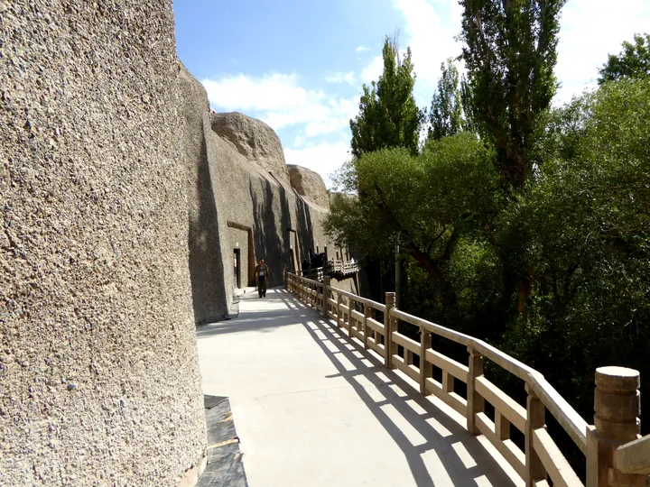 A cliffside walkway past rock-cut cave entrances at the Western Thousand Buddha Caves, Dunhuang City. · 酒泉市敦煌市西千佛洞崖壁栈道及石窟洞口。 Source-recorded photograph date: 7 November 2015 (original upload date).
Western Thousand Buddha Caves西千佛洞
Buddhist cave temples on a Dang River cliff 35 km southwest of Dunhuang, with 22 decorated caves from the Northern Wei to the Yuan.
Read the place guide → The entrance gate of the Yang Guan (Sunny Pass) scenic area near Dunhuang, Gansu · 甘肃敦煌阳关遗址景区大门 Source-recorded photograph date: 7 November 2015 (original upload date).
Yangguan Pass Ruins阳关遗址
Ruins of the Han pass on the Silk Road's southern route, 70 km southwest of Dunhuang: a lone beacon tower and a sand flat of foundations and potsherds.
Read the place guide →Crescent Lake and the surrounding dunes of Mingsha Shan, Dunhuang · 敦煌鸣沙山月牙泉 Source-recorded photograph date: 2023-09-18 10:12:14.Mingsha Mountain and Crescent Moon Spring鸣沙山月牙泉
A ring of singing sand dunes enclosing a small crescent-shaped spring 5 km southwest of Dunhuang, rated a 5A scenic area in 2015.
Read the place guide → Yumen Oilfield Industrial Heritage · 玉门油田工业遗产
Yumen Oilfield Industrial Heritage玉门油田工业遗产
The Yumen oilfield industrial heritage (玉门油田工业遗产) is the group of surviving oil-industry sites in the old Yumen urban area of Jiuquan, Gansu. Its centrepiece is Lao Yi Jing, well No. 1 of the Laojunmiao oilfield, which the sources treat as the discovery well of the Yumen oilfield; the sites now form part of the Yumen oilfield red tourism scenic area.
Read the place guide →The rammed-earth city walls of Suoyang City Ruins, Guazhou County, Jiuquan · 酒泉市瓜州县锁阳城遗址城墙 Source-recorded photograph date: 2016-08-05 18:01:36.Suoyang City Ruins锁阳城遗址
Walled Silk Road city ruins in the Gobi near Guazhou, founded in 295 and abandoned under the Ming; World Heritage since 2014.
Read the place guide → AI illustration · AI 示意图(仅供参考,非该地点实拍)
Son of the Earth Sculpture大地之子
Son of the Earth Sculpture (大地之子) is a large outdoor sculpture of a sleeping infant on the Gobi at Guazhou county in Jiuquan, Gansu. It is about 15 metres long, 9 metres wide and 4.3 metres high, is made mainly of red sandstone, and was installed in 2016.
Read the place guide → Touming Mengke Glacier Viewing Route · 透明梦柯冰川开放观景线路
Touming Mengke Glacier Viewing Route透明梦柯冰川开放观景线路
The catalogue's entry 透明梦柯冰川开放观景线路 names the open glacier-viewing route in 肃北蒙古族自治县, 酒泉市, Gansu. The sources found in this round put two numbered glaciers under the name 透明梦柯: the 12号冰川 at 老虎沟, whose viewing route a December 2017 Xinhua dispatch records as closed, and the 29号冰川 at 大扎仔沟 in 党城湾镇, which a July 2020 Lanzhou Morning Post report describes as still normally open and, at that time, as the only glacier in Gansu open to visitors.
Read the place guide → AI illustration · AI 示意图(仅供参考,非该地点实拍)
Jiuquan Shengji Garden酒泉胜迹
酒泉胜迹 (Jiuquan Shengji) is a classical garden in 肃州区, 酒泉市, Gansu, listed in the Gansu provincial A-level tourist attraction register under the name 西汉酒泉胜迹 at 酒泉市肃州区公园路 100号 with a 4A rating. The Jiuquan municipal government says it was formerly 酒泉公园, was named 泉湖公园 in 1942 and renamed 酒泉公园 in 1956, and calls it the only completely preserved Han-dynasty garden in the Hexi Corridor.
Read the place guide →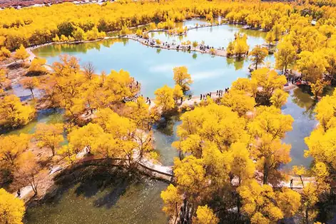 Jinta Desert Poplar Forest · 金塔沙漠胡杨林
Jinta Desert Poplar Forest金塔沙漠胡杨林
金塔沙漠胡杨林 (Jinta desert poplar forest) is a poplar-and-water scenic area north-west of Jinta county town in 酒泉市, Gansu, listed in the Gansu provincial A-level tourist attraction register as 金塔县沙漠胡杨林景区 with a 4A rating. The Jiuquan municipal government office gives its distance from the county town as 8 km, its area as more than 80,000 mu, and a layout of an entrance service zone and five further zones, of which the 金波湖–poplar forest zone is the core.
Read the place guide → Aksay Old County Town Ruins · 阿克塞老县城
Aksay Old County Town Ruins阿克塞老县城
Boluo Zhuanjing (博罗转井) is the abandoned former seat of Aksay Kazakh Autonomous County in Jiuquan municipality, Gansu — a ruined town at the foot of Dangjin Shan in the Altun Mountains, at the far western edge of the province, and now used as a film and television location.
Read the place guide →Local life & food
Jiuquan local specialties
酒泉市特色美食 · 12 specialties to discover
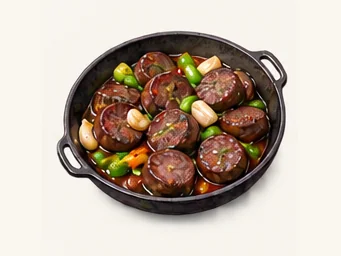 Jiuquan griddled blood sausage 酒泉炕血肠AI illustration · AI 示意图
The outside can be lightly crisp, while the center remains dense and soft. Blood and the sausage's seasonings give it a stronger character than a plain meat sausage.
Source ↗Read the dish guide → Jiuquan guokui bread 酒泉锅盔AI illustration · AI 示意图
The outside is firm and toasted, while the close crumb is mildly wheaty and filling rather than fluffy or sweet.
Source ↗Read the dish guide →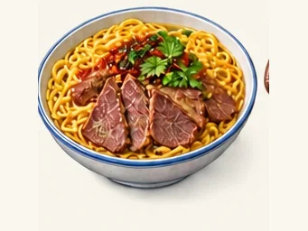 Dunhuang donkey-meat yellow noodles 敦煌驴肉黄面AI illustration · AI 示意图
The noodles have a firm, springy bite, while the sliced meat is dense and aromatic. Sauce brings the two components together.
Source ↗Read the dish guide →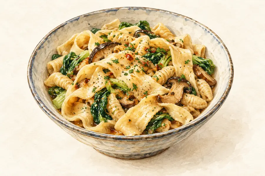 Dunhuang Braised Flatbread with Mutton 敦煌胡羊焖饼AI illustration · AI 示意图(仅供参考,非实拍)
Dunhuang Braised Flatbread with Mutton (敦煌胡羊焖饼) is a one-pot dish of the Dunhuang (敦煌) and Jiuquan (酒泉) area of Gansu: red-braised lamb ribs with very thin pancakes cooked in the same pot and finished together in the broth.
Read the dish guide → Dunhuang Cold Noodle Sheets 敦煌酿皮AI illustration · AI 示意图(仅供参考,非实拍)
Dunhuang Cold Noodle Sheets (敦煌酿皮) are sheets of wheat starch cut into long strips and served with pieces of wheat gluten under a sour, hot dressing.
Read the dish guide → Jiuquan Thick Peppery Chicken Soup 酒泉糊锅
Jiuquan Thick Peppery Chicken Soup (酒泉糊锅) is a chicken broth thickened with starch and loaded with ginger and pepper, served in Jiuquan (酒泉), Gansu, with wheat gluten, fried dough twists and starch sheets dropped in as each bowl is filled.
Read the dish guide →Photo adjustments
EXIF orientation normalized; resized without changing aspect ratio; converted to WebP. No subject edits.
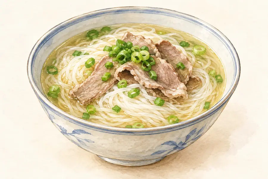 Suzhou Mutton Vermicelli Soup 肃州羊肉粉汤AI illustration · AI 示意图(仅供参考,非实拍)
Suzhou Mutton Vermicelli Soup (肃州羊肉粉汤) is listed among the local specialties of Jiuquan, Gansu. The name includes 羊肉 (lamb or mutton). The term 汤 points to soup.
Read the dish guide → Guazhou Cynomorium Fried Cake 瓜州锁阳油饼AI illustration · AI 示意图(仅供参考,非实拍)
Guazhou Cynomorium Fried Cake (瓜州锁阳油饼) is a fried flatbread made from wheat flour and powdered suoyang (锁阳, Cynomorium), a rare plant that grows in sand.
Read the dish guide →All dish names · 全部菜名 (12)
- Jiuquan griddled blood sausage · 酒泉炕血肠
- Jiuquan guokui bread · 酒泉锅盔
- Dunhuang donkey-meat yellow noodles · 敦煌驴肉黄面
- Dunhuang Braised Flatbread with Mutton · 敦煌胡羊焖饼
- Dunhuang Cold Noodle Sheets · 敦煌酿皮
- Jiuquan Thick Peppery Chicken Soup · 酒泉糊锅
- Suzhou Mutton Vermicelli Soup · 肃州羊肉粉汤
- Guazhou Cynomorium Fried Cake · 瓜州锁阳油饼
- Jinta Lamb · 金塔羊肉
- Yumen Mutton with Braised Flatbread · 玉门羊肉焖饼
- Apricot-skin drink · 杏皮水
- Dunhuang Fermented Sour Noodles · 敦煌浆水面
More dishes from across Gansu are in the Gansu food guide.
Counties & districts in Jiuquan
7 areas belong directly to Jiuquan.
7 areas
Suzhou District肃州区
Suzhou District is a district of the city of Jiuquan, Gansu Province in the People's Republic of China. It was an important city in its own right. Today, it is the seat of Jiuquan's administration.
Explore the area →CountyJinta County金塔县
Jinta County is a county in the northwest of Gansu province, China, bordering Inner Mongolia to the north and east. It is under the jurisdiction of the prefecture-level city of Jiuquan.
Explore the area →CountyGuazhou瓜州县
Guazhou County, formerly Anxi County (安西县; Ānxī Xiàn) until 2006, is a county in the northwest of Gansu province, China. It is under the administration of Jiuquan City.
Explore the area →Autonomous countySubei Mongol Autonomous County肃北蒙古族自治县
The Subei Mongol Autonomous County is an autonomous county within the prefecture-level city of Jiuquan in the northwest of Gansu Province, China, bordering Xinjiang to the west, Qinghai Province to the…
Explore the area →Show fewer areas
Aksay Kazak Autonomous County阿克塞哈萨克族自治县
Aksay Kazakh Autonomous County is an autonomous county under the prefecture-level city of Jiuquan in Gansu Province, China. The county borders Qinghai Province to the south and Xinjiang to the west.
Explore the area →County-level cityYumen玉门市
Yumen (simplified Chinese: 玉门; traditional Chinese: 玉門; pinyin: Yùmén, literally, "Jade Gate") is a city in western Gansu province, China.
Explore the area →County-level cityDunhuang敦煌市
Dunhuang is a county-level city in northwestern Gansu Province, Northwestern China. According to the 2010 Chinese census, the city has a population of 186,027, though 2019 estimates put the city's population…
Explore the area →No areas match this name.
Plan your visit
Getting there
Search for 酒泉市 in a map app to find stations and your accommodation.
Where to stay →Build your route
Mogao Caves and Crescent Lake · Mingsha Mountain dunes are about 15 km apart in a straight line. The linked place guides have entrance and visit details.
Continue with Gansu →More in Gansu
Sources & geographic information
Administrative names and parent areas: Official geographic directory · Reference date 2026-09-06.
Some facts checked against 酒泉市 — Wikipedia contributors, CC BY-SA 4.0.
Some facts checked against 莫高窟 — Wikipedia contributors, CC BY-SA 4.0.
Some facts checked against 锁阳城遗址 — Wikipedia contributors, CC BY-SA 4.0.
Photo: Mogao Caves · xiquinhosilva · CC BY 2.0. Wikimedia thumbnail; fitted to the ranking-card frame.
.jpg)
Photo: Crescent Lake · Mingsha Mountain dunes · N509FZ · CC BY-SA 4.0. Wikimedia thumbnail; fitted to the ranking-card frame.
.jpg)
Photo: Yumen Pass · 张骐 · CC BY-SA 3.0. Full frame retained; proportionally resized and converted to WebP. No retouching or changes to the photographed subject. Card displays may crop the view.

Photo: Yang Pass · 张骐 · CC BY-SA 3.0. Full frame retained; proportionally resized and converted to WebP. No retouching or changes to the photographed subject. Card displays may crop the view.

Photo: Yulin Caves · Redpipe · CC BY-SA 3.0. Full frame retained; proportionally resized and converted to WebP. No retouching or changes to the photographed subject. Card displays may crop the view.

Photo: Suoyang City · Zanhe · CC BY-SA 4.0. Full frame retained; proportionally resized and converted to WebP. No retouching or changes to the photographed subject. Card displays may crop the view.

Photo: Dunhuang · 慕尼黑啤酒 · CC BY-SA 3.0. Full frame retained; proportionally resized and converted to WebP. No retouching or changes to the photographed subject. Card displays may crop the view.

Photo: Western Han Jiuquan Scenic Park · Source photographer · License not provided. EXIF orientation normalized; resized without changing aspect ratio; converted to WebP. No subject edits.
Photo: Boluo Zhuanjing Film Location · Source photographer · License not provided. EXIF orientation normalized; resized without changing aspect ratio; converted to WebP. No subject edits.
Photo: Dunhuang Museum · Hiroki Ogawa · CC BY 3.0. Full frame retained; proportionally resized and converted to WebP. No retouching or changes to the photographed subject. Card displays may crop the view.

Photo: Dunhuang Historical Film City · Source photographer · License not provided. EXIF orientation normalized; resized without changing aspect ratio; converted to WebP. No subject edits.
Photo: Dunhuang Yardang National Geopark · 张骐 · CC BY-SA 3.0. Full frame retained; proportionally resized and converted to WebP. No retouching or changes to the photographed subject. Card displays may crop the view.

Photo: Yumen Pass Ruins · 张骐 · CC BY-SA 3.0. Full frame retained; proportionally resized and converted to WebP. No retouching or changes to the photographed subject. Card displays may crop the view.
Photo: Western Thousand Buddha Caves · Hiroki Ogawa · CC BY 3.0. Full frame retained; proportionally resized and converted to WebP. No retouching or changes to the photographed subject. Card displays may crop the view.

Photo: Yangguan Pass Ruins · Hiroki Ogawa · CC BY 3.0. Full frame retained; proportionally resized and converted to WebP. No retouching or changes to the photographed subject. Card displays may crop the view.
.jpg)
Photo: Mingsha Mountain and Crescent Moon Spring · N509FZ · CC BY-SA 4.0. Wikimedia thumbnail; fitted to the ranking-card frame.
Photo: Yumen Oilfield Industrial Heritage · Source photographer · License not provided. EXIF orientation normalized; resized without changing aspect ratio; converted to WebP. No subject edits.
Photo: Suoyang City Ruins · Zanhe · CC BY-SA 4.0. Full frame retained; proportionally resized and converted to WebP. No retouching or changes to the photographed subject. Card displays may crop the view.
Photo: Touming Mengke Glacier Viewing Route · Source photographer · License not provided. EXIF orientation normalized; resized without changing aspect ratio; converted to WebP. No subject edits.
Photo: Jinta Desert Poplar Forest · Source photographer · License not provided. EXIF orientation normalized; resized without changing aspect ratio; converted to WebP. No subject edits.
Photo: Aksay Old County Town Ruins · Source photographer · License not provided. EXIF orientation normalized; resized without changing aspect ratio; converted to WebP. No subject edits.
Map data © OpenStreetMap contributors. Pins mark approximate centres, not entrances or boundaries.