


Get to know Yangjiang

Photo adjustments
Full frame retained; proportionally resized and converted to WebP. No retouching or changes to the photographed subject. Card displays may crop the view.
- Administrative area
- Prefecture-level city · 地级市
- Part of
- Guangdong
- Chinese name
- 阳江市
- Local areas
- 4 local areas
Area & population
- Area in the source
- 7,955.27 km²
- Population · 2020 census
- 2,602,959
- Administrative seat
- Jiangcheng District
Source: cited geographic source, as of the dates shown.
Setting and landscape
The land slopes from north to south. Ehuangzhang (鹅凰嶂) rises to 1,338 metres in the Wangfu range (望夫山脉), and the 199-kilometre Moyang River, which gave the city its name, flows south through the whole city to the sea. Sixty-eight main islands lie off the coast, and typhoons and heavy rain are common in summer and autumn.
History
The name Yangjiang County first appeared under the Sui, and in 1048 the prefecture governed from here was renamed Nan'en Prefecture (南恩州). In 1097 the prefect built an earthen town beside Tuo Hill (鼍山), the forerunner of the present city; because the seat long stayed below the hill, Yangjiang is also called Tuocheng (鼍城).
Yangjiang speech (阳江话) is a local Yue dialect that differs from Guangzhou Cantonese, while a Southern Min "sea speech" (海话) is spoken in Rudong (儒洞) and Shaba (沙扒) in Yangxi County (阳西县). Lacquerware, one of the "three treasures of Yangjiang" (阳江三宝), has been made here since at least the late Ming or early Qing; by the late Qing a locally developed cashew lacquer set it apart, and much of the output went to Southeast Asia. The national intangible heritage list, which added the craft in 2011, singles out its leather-bodied trunks and pillows.
What to see
Hailing Island (海陵岛) lies in the city's southwest. Dajiao Bay (大角湾) is a national 5A scenic area, and Shili Yintan (十里银滩), the "ten-li silver beach", runs for 16.5 kilometres along the south of the island. On the beach's west side the Maritime Silk Road Museum of Guangdong (广东海上丝绸之路博物馆), a national first-grade museum, holds the Song merchant ship Nanhai No. 1 (南海一号), from which 180,000 objects have been recovered. Zhapo (闸坡), a national central fishing port, has a fishermen's street with an exhibition on Tanka (疍家) boat-dweller life. Chunwan (春湾) and Lingxiao Cave (凌霄岩) in Yangchun (阳春市) form a provincial tourist resort.
Food and local products
Chengcun oysters (程村蚝) come from beds at the mouths of the Fengtou (丰头河) and Zhigong (织篢河) rivers in Yangxi, where the water is neither too salty nor too fresh; oysters have been farmed there for over 500 years and are also dried or made into oyster sauce. Zhuchanglu (猪肠碌), named for its likeness to pork intestine, is a sheet of rice noodle rolled around bean sprouts and fried rice noodles, topped with sesame and spring onion and dressed with beef-brisket sauce. Yangchun grows the medicinal plant chunsharen (春砂仁).
Highlights
- Maritime Silk Road Museum of Guangdong 广东海上丝绸之路博物馆: National first-grade museum on Hailing Island holding the Song merchant ship Nanhai No. 1.
- Dajiao Bay 大角湾: Hailing Island bay, a national 5A scenic area.
- Shili Yintan 十里银滩: Beach running 16.5 km along the south of Hailing Island.
- Yangjiang lacquerware 阳江漆器: Lacquer craft known for leather-bodied trunks and pillows and a local cashew lacquer; national intangible heritage since 2011.
- Chengcun oysters 程村蚝: Farmed for over 500 years in brackish river mouths in Yangxi.
Sources for this guide
地理气候_阳江市人民政府门户网站 · Yangjiang Municipal People's Government
阳江市 广东省人民政府门户网站 · People's Government of Guangdong Province (text from the Guangdong Provincial Tourism Administration)
广东海上丝绸之路博物馆——大角湾——天麓山——闸坡渔家风情街区——闸坡国家中心渔港_阳江市人民政府门户网站 · Yangjiang Municipal People's Government
漆器髹饰技艺(阳江漆器髹饰技艺) - 中国非物质文化遗产网·中国非物质文化遗产数字博物馆 - 中国非物质文化遗产网非遗 · China Intangible Cultural Heritage Network (China National Center for the Safeguarding of Intangible Cultural Heritage)
阳西程村蚝 广东省人民政府门户网站 · People's Government of Guangdong Province (text from the Guangdong Provincial Tourism Administration)
猪肠碌 广东省人民政府门户网站 · People's Government of Guangdong Province (text from the Guangdong Provincial Tourism Administration)
国家5A级旅游景区 - 维基百科,自由的百科全书 · Wikipedia (Chinese) · CC BY-SA 4.0
阳江市 - 维基百科,自由的百科全书 · Wikipedia (Chinese) · CC BY-SA 4.0
Original English written from the listed sources and checked sentence by sentence against quoted extracts by a separate reviewer. Updated 2026-09-30.
Explore Yangjiang
Core places to explore, with English and Chinese names.
Places to explore around Yangjiang
 Dajiao Bay beach on Hailing Island, Yangjiang · 阳江海陵岛大角湾海滩 Photograph date recorded by the source: 15 September 2013, 08:02:15.
Hailing Island海陵岛
Hailing Island combines broad beaches with an active fishing-port landscape. Dajiao Bay provides a developed beachfront, while the boats and working quays around Zhapo reveal another use of the same coast. The Maritime Silk Road…
Read the place guide →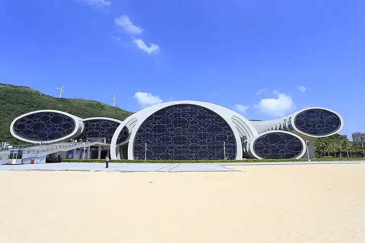 Maritime Silk Road Museum of Guangdong exterior, Hailing Island · 海陵岛广东海上丝绸之路博物馆外观 Photograph date recorded by the source: 15 September 2013, 10:50:33.
Maritime Silk Road Museum of Guangdong广东海上丝绸之路博物馆
This Hailing Island museum was built around the recovered Nanhai I shipwreck. The vessel and its surrounding sediment were lifted together, allowing the hull and cargo to be studied as a connected archaeological site. The…
Read the place guide →Dajiao Bay beach and its seafront monument on Hailing Island, Yangjiang · 阳江海陵岛大角湾海滩. Source-recorded photograph date: 2013-09-15 08:02:15.Hailing Island Dajiao Bay海陵岛大角湾
Dajiao Bay (大角湾) is a bay on Hailing Island in the southwest of Yangjiang, Guangdong, described in a Yangjiang Daily account of the city's tourism routes as a national 5A attraction combining sea swimming, holidaying, seafood and dried-seafood buying. Its name is carried by the Hailing Island Dajiaowan Maritime Silk Road Tourism Area, the island's one national AAAAA-rated scenic area.
Read the place guide → Lingxiao Cave · 凌霄岩
Lingxiao Cave凌霄岩
Four-level underground-river karst cave in Helang Town, Yangchun, with a column-filled main hall; a Guangdong provincial scenic area and national geopark.
Read the place guide → Chunwan Stone Forest · 春湾石林
Chunwan Stone Forest春湾石林
Chunwan Stone Forest (春湾石林), also called Lianhua Cave Stone Forest, is a group of rock peaks and named boulders at Chunwan town in Yangchun, under Yangjiang in Guangdong. It sits in the northeast of the Chunwan Scenic Area, which holds a national AAAA rating.
Read the place guide →Local life & food
Yangjiang local specialties
阳江市特色美食 · 9 specialties to discover
 Yangjiang rolled rice sheets 猪肠碌AI illustration · AI 示意图
The wrapper is smooth and yielding, contrasting with shredded vegetables and strongly seasoned bits inside.
Source ↗Read the dish guide → Chengcun Oysters 程村蚝
Chengcun Oysters (程村蚝) are oysters farmed in the sea off Chengcun town (程村镇) in Yangxi County (阳西县), Yangjiang (阳江), on the South China Sea coast of Guangdong.
Read the dish guide →Photo adjustments
EXIF orientation normalized; resized without changing aspect ratio; converted to WebP. No subject edits.
 Yangchun Steamed Pork Ribs with Amomum 阳春春砂仁蒸排骨
Yangchun Steamed Pork Ribs with Amomum (阳春春砂仁蒸排骨) is a traditional dish of Yangchun (阳春), a small city in western Guangdong, built around a local speciality, Yangchun amomum (春砂仁), the dried fruit of a plant of the ginger family.
Read the dish guide →Photo adjustments
EXIF orientation normalized; resized without changing aspect ratio; converted to WebP. No subject edits.
 Yangxi Chengcun Oyster Rice 阳西程村蚝饭AI illustration · AI 示意图(仅供参考,非实拍)
Yangxi Chengcun Oyster Rice (阳西程村蚝饭) is the oyster rice of Chengcun (程村), a coastal town in Yangxi County (阳西县), Yangjiang (阳江).
Read the dish guide →Yangjiang Goose Fried Rice 阳江鹅乸饭AI illustration · AI 示意图(仅供参考,非实拍)
Yangjiang Goose Fried Rice (阳江鹅乸饭) is rice stir-fried with diced meat from an old mother goose (鹅乸), a dish of Yangjiang (阳江).
Read the dish guide → Yangjiang Toasted Rice-Flour Cakes 粉酥AI illustration · AI 示意图(仅供参考,非实拍)
Yangjiang Toasted Rice-Flour Cakes (粉酥) are Yangjiang's toasted-rice cakes (炒米饼): rice is first dry-fried, then ground, and the flour is pressed into wooden moulds and baked.
Read the dish guide →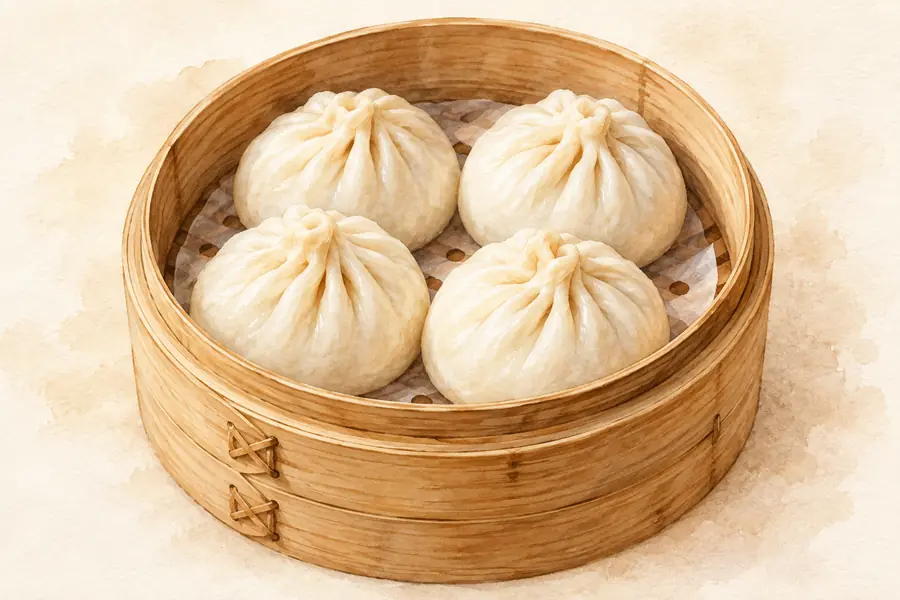 Hailing Island Rice-Flour Dumplings 叶薄包AI illustration · AI 示意图(仅供参考,非实拍)
Hailing Island Rice-Flour Dumplings (叶薄包) are filled dumplings with a rice-flour skin from Hailing Island (海陵岛) in Yangjiang (阳江), Guangdong. In the island's dialect they also have a second name (角子).
Read the dish guide → Ash-Lye Rice Cake 灰糍
Ash-Lye Rice Cake (灰糍) is a yellow rice-flour sweet from Yangjiang (阳江), Guangdong, made by working the flour with plant-ash water (草木灰水).
Read the dish guide →Photo adjustments
EXIF orientation normalized; resized without changing aspect ratio; converted to WebP. No subject edits.
All dish names · 全部菜名 (9)
- Yangjiang rolled rice sheets · 猪肠碌
- Chengcun Oysters · 程村蚝
- Yangchun Steamed Pork Ribs with Amomum · 阳春春砂仁蒸排骨
- Yangxi Chengcun Oyster Rice · 阳西程村蚝饭
- Yangjiang Goose Fried Rice · 阳江鹅乸饭
- Yangjiang Toasted Rice-Flour Cakes · 粉酥
- Hailing Island Rice-Flour Dumplings · 叶薄包
- Ash-Lye Rice Cake · 灰糍
- Hailing Island Seafood · 海陵岛海鲜
More dishes from across Guangdong are in the Guangdong food guide.
Counties & districts in Yangjiang
4 areas belong directly to Yangjiang.
4 areas
Jiangcheng District 江城区
Jiangcheng is a district of Yangjiang, Guangdong province, China.
Explore the area →DistrictYangdong District 阳东区
Yangdong District (simplified Chinese: 阳东区; traditional Chinese: 陽東區; pinyin: Yángdōng Qū; Jyutping: Jeong4dung1keoi1) is a district of the city of Yangjiang, Guangdong Province, China.
Explore the area →CountyYangxi County 阳西县
Yangxi County (simplified Chinese: 阳西县; traditional Chinese: 陽西縣; pinyin: Yángxī Xiàn) is a coastal county in the southwest of Guangdong Province, China, facing the South China Sea to the south.
Explore the area →County-level cityYangchun 阳春市
Yangchun, alternately romanized as Yeungchun, (local pronunciation: [jɛŋ31 ʦʰɐn45]) is a county-level city in southwestern Guangdong, China, administered as a part of the prefecture-level city of Yangjiang.
Explore the area →No areas match this name.
Plan your visit
Getting there
Search for 阳江市 in a map app to find stations and your accommodation.
Where to stay →Build your route
Hailing Island and Maritime Silk Road Museum of Guangdong are about 6 km apart in a straight line. The linked place guides have entrance and visit details.
Continue with Guangdong →More in Guangdong
Sources & geographic information
Administrative names and parent areas: Official geographic directory · Reference date 2026-09-06.
Some facts checked against 国家5A级旅游景区 — Wikipedia contributors, CC BY-SA 4.0.
Some facts checked against 阳江市 — Wikipedia contributors, CC BY-SA 4.0.
Photo: Hailing Island · Zhangzhugang · Zhangzhugang — Yangjiang_Hailing_Dao_Dajiao_Wan_2013.09.15_08-02-15.jpg — CC BY-SA 4.0 · CC BY-SA 4.0. Full frame retained; proportionally resized and converted to WebP. No retouching or changes to the photographed subject. Card displays may crop the view.

Photo: Maritime Silk Road Museum of Guangdong · Zhangzhugang · Zhangzhugang — Yangjiang_Hailing_Dao_Nanhai_1_Hao_2013.09.15_10-50-33.jpg — CC BY-SA 4.0 · CC BY-SA 4.0. The exact downloaded source bytes are separately retained and hashed. Prepared JPEG is proportionally reduced to a maximum 720-pixel long edge; full frame retained, no subject alteration. Final website rendition: full frame retained, proportionally resized to at most 720 pixels and converted to WebP. No additional retouching or subject alteration. Card displays may crop the view.

Photo: Hailing Island Dajiao Bay · Zhangzhugang · CC BY-SA 4.0. Full source framing retained; proportionally resized and converted to WebP. No retouching or subject alteration. Card displays may crop the view.
Photo: Lingxiao Cave · Source photographer · License not provided. EXIF orientation normalized; resized without changing aspect ratio; converted to WebP. No subject edits.
Photo: Chunwan Stone Forest · Source photographer · License not provided. EXIF orientation normalized; resized without changing aspect ratio; converted to WebP. No subject edits.
Map data © OpenStreetMap contributors. Pins mark approximate centres, not entrances or boundaries.