


Get to know Haibei Tibetan Autonomous Prefecture
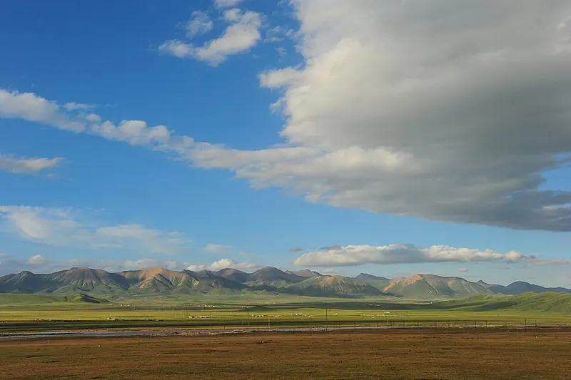
Photo adjustments
Full frame retained; proportionally resized and converted to WebP. No retouching or changes to the photographed subject. Card displays may crop the view.
- Administrative area
- Autonomous prefecture · 自治州
- Part of
- Qinghai
- Chinese name
- 海北藏族自治州
- Local areas
- 4 local areas
Area & population
- Population · 2020
- 265,322
- Administrative seat
- Haiyan County (Xihai)
Source: cited geographic source, as of the dates shown.
Explore Haibei Tibetan Autonomous Prefecture
Core places to explore, with English and Chinese names.
Ami Dongsuo Scenic Area 阿咪东索景区
Naked Carp Migration Viewing Area 湟鱼洄游观景区
Atomic City Memorial Museum 原子城纪念馆
Jinyintan Grassland 金银滩草原
Zhuo'er Mountain 卓尔山
Qilian Grassland 祁连大草原
Gangshika Snow Peak Viewing Area 岗什卡雪峰正规开放观景区
Menyuan Rapeseed Flower Sea 门源百里油菜花海
Menyuan Hui Autonomous County 门源回族自治县
Qilian County 祁连县
Haiyan County 海晏县
Gangca County 刚察县
Places to explore around Haibei Tibetan Autonomous Prefecture
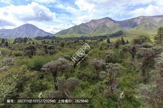 Ami Dongsuo Scenic Area · 阿咪东索景区
Ami Dongsuo Scenic Area阿咪东索景区
Ami Dongsuo is a highland landscape destination in Qilian County, with pasture, forest and mountain viewpoints.
Read the place guide →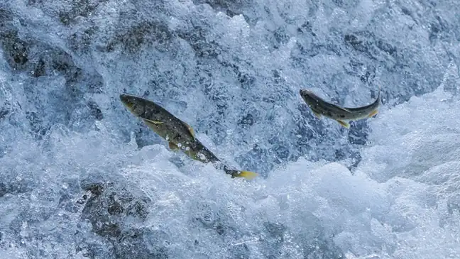 Naked Carp Migration Viewing Area · 湟鱼洄游观景区
Naked Carp Migration Viewing Area湟鱼洄游观景区
The naked carp migration viewing area (湟鱼洄游观景区) is a descriptive label for the fish-viewing places on the rivers of Gangca County, Haibei Tibetan Autonomous Prefecture, Qinghai, where the annual migration of the naked carp is watched. The provincial page names the viewing platform at Gangca's Naked Carp Home (湟鱼家园) and the fish-viewing corridor built on the Quanji River, which it says has become a fish-viewing scenic area.
Read the place guide →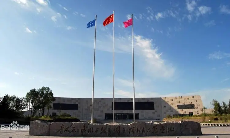 Atomic City Memorial Museum · 原子城纪念馆
Atomic City Memorial Museum原子城纪念馆
Atomic City Memorial explains the history of the former nuclear-research base on the Jinyintan grassland. Its exhibition follows the base from planning and construction through research and retirement. Photographs and objects…
Read the place guide → White stupas standing on the open grassland of Jinyintan, Haiyan County · 海晏县金银滩草原上的白色佛塔 Source-recorded photograph date: 2018-08-28 13:55:02.
Jinyintan Grassland金银滩草原
Jinyintan (金银滩草原) is a grassland in Haiyan County, Haibei Tibetan Autonomous Prefecture, Qinghai, lying by Qinghai Lake at the foot of Tongbao Mountain. It is the setting of Wang Luobin's song 《在那遥远的地方》 and the site of China's first nuclear weapons research and production base, the 221 plant, known after the fact as the Atomic City.
Read the place guide →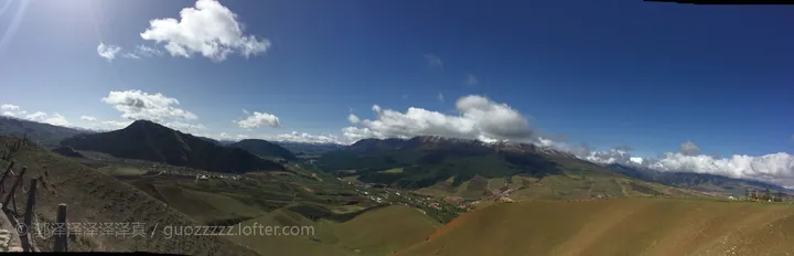 A wide mountain panorama: rounded green and dry-gold slopes with terracing sweeping down in the foreground, a valley floor with a small town, fields and a road in the middle distance, darker forested ridges beyond and a snow-streaked range on the horizon; a deep blue sky with cumulus and cirrus, a dark hill at the left, a fence post at the left edge, a small white structure on the right ridge and a white watermark © 郭泽泽泽泽泽 / guozzzzz.lofter.com at the lower left.
Zhuo'er Mountain卓尔山
Zhuo'er Mountain (卓尔山) is a mountain spur of the Qilian range standing on the north bank of the Babao River in Qilian County, Haibei Tibetan Autonomous Prefecture, Qinghai, whose Tibetan name Zongmu Mayouma (宗穆玛釉玛) is given as meaning the beautiful rosy queen.
Read the place guide → Qilian Grassland · 祁连大草原
Qilian Grassland祁连大草原
The Qilian grassland (祁连大草原) is the high pasture country of Qilian County in Haibei Tibetan Autonomous Prefecture, Qinghai, in a county the provincial portal places in the middle section of the Qilian range, where a provincial research team has spent more than a decade restoring degraded alpine pasture.
Read the place guide →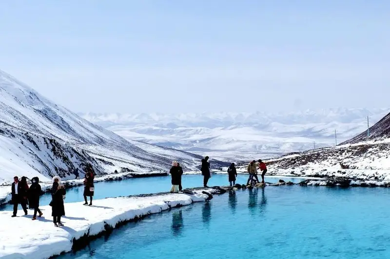 Gangshika Snow Peak Viewing Area · 岗什卡雪峰正规开放观景区
Gangshika Snow Peak Viewing Area岗什卡雪峰正规开放观景区
Gangshika Snow Peak (岗什卡雪峰) is a snow peak of the Qilian range in Menyuan Hui Autonomous County, Haibei Tibetan Autonomous Prefecture, Qinghai, about 40 km north-west of the county town, with its main summit at 5,254.5 m.
Read the place guide → Menyuan Rapeseed Flower Sea · 门源百里油菜花海
Menyuan Rapeseed Flower Sea门源百里油菜花海
Menyuan's hundred-li rapeseed flower sea (门源百里油菜花海) is the belt of rapeseed fields around Menyuan Hui Autonomous County in Haibei Tibetan Autonomous Prefecture, Qinghai, which the county's own account runs from Qingshizui in the west to Yulongtan in the east and from the Lenglongling range in the north to Daban mountain in the south.
Read the place guide →Local life & food
Haibei Tibetan Autonomous Prefecture local specialties
海北藏族自治州特色美食 · 10 specialties to discover
 Haiyan ten-bowl feast 海晏十大碗AI dish illustration / AI 菜品示意图
The appeal is the variety across bowls rather than one fixed seasoning. Portions can be substantial.
Source ↗Read the dish guide →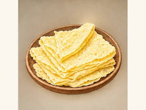 Menyuan milk skin 门源奶皮AI dish illustration · AI 菜品示意图
The texture is richer and denser than yogurt, with a creamy dairy flavor and a possible slight chew. Sweetness depends on whether sugar is added.
Source ↗Read the dish guide →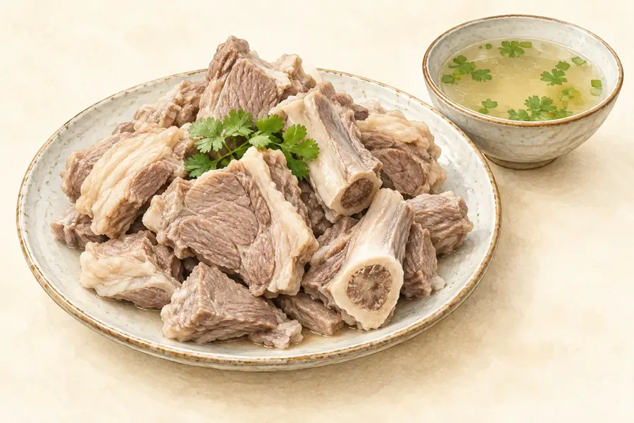 Qilian Mutton Stewed with Yellow Mushrooms 祁连黄蘑菇炖羊肉AI illustration · AI 示意图(仅供参考,非实拍)
Qilian Mutton Stewed with Yellow Mushrooms (祁连黄蘑菇炖羊肉) is listed among the local specialties of Haibei Tibetan Autonomous Prefecture, Qinghai. The name includes 羊肉 (lamb or mutton), 蘑菇 (mushrooms). 炖 describes slow simmering.
Read the dish guide →Gangca Tibetan Mutton 刚察藏羊肉AI illustration · AI 示意图(仅供参考,非实拍)
Gangca Tibetan Mutton (刚察藏羊肉) comes from the highland type of Tibetan sheep raised in Gangca (刚察), Qinghai (青海).
Read the dish guide → Haiyan Yak Meat 海晏牦牛肉AI illustration · AI 示意图(仅供参考,非实拍)
Haiyan Yak Meat (海晏牦牛肉) is listed among the local specialties of Haibei Tibetan Autonomous Prefecture, Qinghai. The name includes 牛肉 (beef).
Read the dish guide → Tibetan Butter Tea 酥油茶AI dish illustration · AI 菜品示意图
Tibetan Butter Tea (酥油茶) appears in the local food directory for Qinghai. The Chinese introduction below explains the named food and its preparation in the linked culinary reference.
Source ↗Read the dish guide →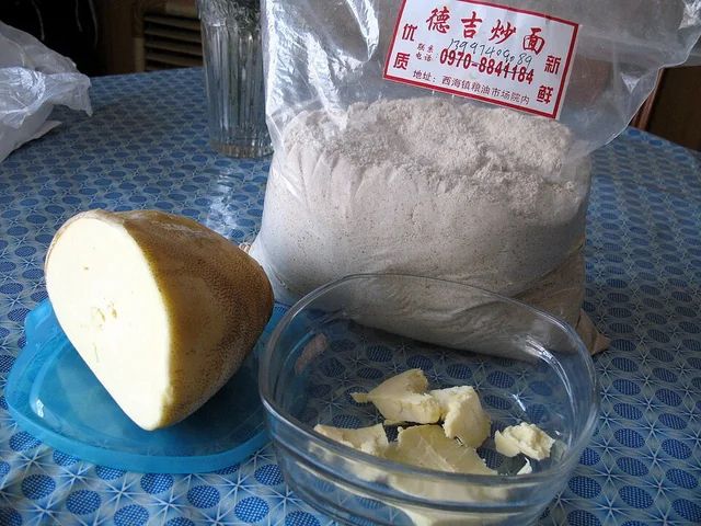 Tsampa Roasted Barley Flour 糌粑Dish photograph · see caption for context
Tsampa Roasted Barley Flour (糌粑) appears in the local food directory for Qinghai. The Chinese introduction below explains the named food and its preparation in the linked culinary reference.
Source ↗Read the dish guide →
Photo adjustments
EXIF orientation applied where present; resized proportionally to at most 640 px on the long edge and encoded as WebP. No crop, retouching, recoloring or subject changes.
 Highland Barley Cake 青稞饼AI dish illustration · AI 菜品示意图
Highland Barley Cake (青稞饼) is a flatbread made from highland barley (青稞) flour and either cooked on a griddle or baked.
Read the dish guide →All dish names · 全部菜名 (10)
More dishes from across Qinghai are in the Qinghai food guide.
Counties & districts in Haibei Tibetan Autonomous Prefecture
4 areas belong directly to Haibei Tibetan Autonomous Prefecture.
4 areas
Menyuan Hui Autonomous County 门源回族自治县
Menyuan Hui Autonomous County (simplified Chinese: 门源回族自治县; traditional Chinese: 門源回族自治縣; pinyin: Ményuán Huízú Zìzhìxiàn, Xiao'erjing: مٍیُوًا خُوِذُو ذِجِشِیًا; Tibetan: སེམས་ཉིད་ཧུའེ་རིགས་རང་སྐྱོང་ཞན།) is…
Explore the area →CountyQilian County 祁连县
Qilian County, in Tibetan Dhola County, is a county of Haibei Tibetan Autonomous Prefecture, Qinghai Province, China. The Haibei Qilian Airport is located in the county.
Explore the area →CountyHaiyan County 海晏县
Haiyan County is a county of Qinghai Province, China, located on the northeast shore of Qinghai Lake. It is under the administration of Haibei Tibetan Autonomous Prefecture.
Explore the area →CountyGangca County 刚察县
Gangca County (Tibetan: རྐང་ཚ་རྫོང; Chinese: 刚察县) is a county of northeastern Qinghai province, China, on the northern shore of Qinghai Lake.
Explore the area →No areas match this name.
Plan your visit
Getting there
Search for 海北藏族自治州 in a map app to find stations and your accommodation.
Where to stay →Build your route
Ami Dongsuo Scenic Area and Naked Carp Migration Viewing Area are both listed here. The linked place guides have entrance and visit details.
Continue with Qinghai →More in Qinghai
Sources & geographic information
Administrative names and parent areas: Official geographic directory · Reference date 2026-09-06.
Background text adapted from Haibei Tibetan Autonomous Prefecture — Wikipedia contributors, under CC BY-SA 4.0. Text has been shortened and reorganized; source revision 1366283130.
Photo: Ami Dongsuo Scenic Area · Source photographer · License not provided. EXIF orientation normalized; resized without changing aspect ratio; converted to WebP. No subject edits.
Photo: Naked Carp Migration Viewing Area · Source photographer · License not provided. EXIF orientation normalized; resized without changing aspect ratio; converted to WebP. No subject edits.
Photo: Atomic City Memorial Museum · Source photographer · License not provided. EXIF orientation normalized; resized without changing aspect ratio; converted to WebP. No subject edits.
Photo: Jinyintan Grassland · 西安兵马俑 · CC BY-SA 4.0. Full frame retained; proportionally resized and converted to WebP. No retouching or changes to the photographed subject. Card displays may crop the view.

Photo: Zhuo'er Mountain · 郭泽泽泽泽泽真 · CC BY 2.5. Full frame retained; proportionally resized and converted to WebP. No retouching or changes to the photographed subject. Card displays may crop the view.

Photo: Qilian Grassland · Source photographer · License not provided. EXIF orientation normalized; resized without changing aspect ratio; converted to WebP. No subject edits.
Photo: Gangshika Snow Peak Viewing Area · Source photographer · License not provided. EXIF orientation normalized; resized without changing aspect ratio; converted to WebP. No subject edits.
Photo: Menyuan Rapeseed Flower Sea · Source photographer · License not provided. EXIF orientation normalized; resized without changing aspect ratio; converted to WebP. No subject edits.
Map data © OpenStreetMap contributors. Pins mark approximate centres, not entrances or boundaries.