


Get to know Jinjiang
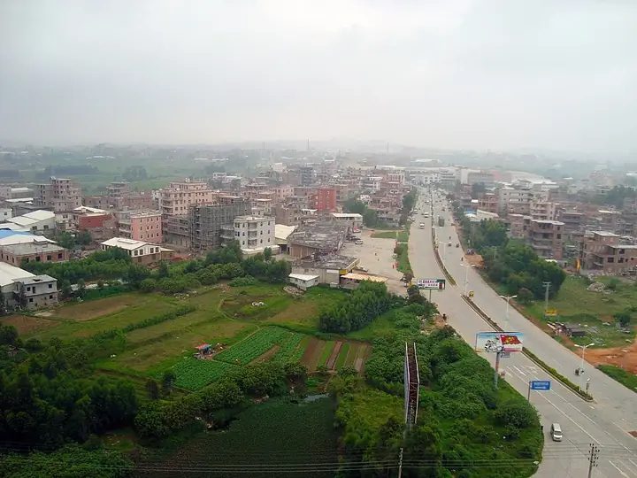
Photo adjustments
Full frame retained; resized proportionally to a maximum dimension of 960 pixels and converted to WebP quality 88. No crop, retouch, generated elements, or subject alteration. Final website rendition: full frame retained, proportionally resized to at most 720 pixels and converted to WebP. No additional retouching or subject alteration. Card displays may crop the view.
- Administrative area
- County-level city · 县级市
- Part of
- Quanzhou
- Chinese name
- 晋江市
- Local areas
- County-level city guide
Area & population
- Area in the source
- 721.70 km²
- Population · 2020 census
- 2,061,551
- Administrative seat
- Luoshan Subdistrict (罗山街道)
Source: cited geographic source, as of the dates shown.
Setting and landscape
Quanzhou Bay (泉州湾) lies to the north-east and the Taiwan Strait to the south-east, and the island of Kinmen (金门岛) faces Jinjiang across the water to the south. Shishi (石狮市) borders it to the east, Nan'an (南安市) to the west and Licheng District (鲤城区) to the north. The ground is mostly gentle plain and low hills, with the flattest land by Quanzhou Bay and around Weitou Bay (围头湾) in the south-west. The highest point is Zimao Mountain (紫帽山) in the north, at 517.8 metres; Lingyuan Mountain (灵源山) rises in the centre.
History
Jinjiang counts as one of the important starting points of the old Maritime Silk Road (海上丝绸之路). Under the Qing it was grouped with Nan'an and Hui'an (惠安) as the "three counties of Quanzhou" (泉州三邑). In January 1951 the old county town and its suburbs became the new city of Quanzhou, and the Jinjiang county seat moved to Qingyang (青阳); the county became a city in 1992. Fujian's first highway, the Quan'an road (泉安路) from Quanzhou to Anhai (安海), was financed by Chen Qingji (陈清机), an overseas Chinese living in Japan, and built between July 1919 and June 1922; it is 27 kilometres long.
What to see
Historic sites include Anping Bridge (安平桥), Cao'an (草庵), which Chinese Wikipedia describes as the only Manichaean temple still standing in mainland China, Anhai's Longshan Temple (龙山寺), dated to 618, and the Cizao kiln sites (磁灶窑址). The coast has the Shenhu Bay National Geopark (深沪湾国家地质公园). The Wudianshi traditional block (五店市传统街区) was Jinjiang's first national 4A scenic area and is a provincial protected site; its 147 historic buildings include the Song-dynasty Cai family temple of Qingyang (青阳蔡氏家庙) and the former homes of Chinese who had emigrated to the Philippines.
Food and local crafts
Seven Jinjiang traditions are on the national intangible-heritage list, among them Nanyin music (泉州南音), Gaojia opera (高甲戏), the building of watertight-bulkhead Fu ships (水密隔舱福船) and Dongshi lantern customs (东石灯俗). The local glove puppetry (晋江布袋木偶戏) belongs to the southern school: it is sung in the Quanzhou tune, unlike the northern-style puppetry of Zhangzhou (漳州). Town specialities include Anhai sea-worm jelly (土笋冻), Dongshi oyster omelette (蚵仔煎), Shenhu fish balls (深沪鱼丸), Meiling meat rice dumplings (梅岭肉粽), and the beef soups sold as Chengzong (成宗牛肉汤) and Chidian (池店牛肉汤).
Highlights
- Anping Bridge 安平桥: Listed among Jinjiang's principal historic sites, together with its White Pagoda.
- Cao'an 草庵: Described by Chinese Wikipedia as mainland China's only surviving Manichaean temple.
- Wudianshi traditional block 五店市传统街区: Jinjiang's first national 4A scenic area, with 147 historic buildings.
- Jinjiang glove puppetry 晋江布袋木偶戏: National intangible heritage since 2006; southern-school puppetry sung in the Quanzhou tune.
Sources for this guide
晋江市 - 维基百科,自由的百科全书 · Wikipedia (Chinese) · CC BY-SA 4.0
木偶戏(晋江布袋木偶戏) - 中国非物质文化遗产网·中国非物质文化遗产数字博物馆 · China Intangible Cultural Heritage Network
Original English written from the listed sources and checked sentence by sentence against quoted extracts by a separate reviewer. Updated 2026-09-25.
Explore Jinjiang
Core places to explore, with English and Chinese names.
Places to explore around Jinjiang
 Wudianshi Historic District · 五店市传统街区
Wudianshi Historic District五店市传统街区
Wudianshi is a preserved neighbourhood in Jinjiang's old Qingyang area, where red-brick houses, ancestral halls and shops express Minnan building traditions.
Read the place guide →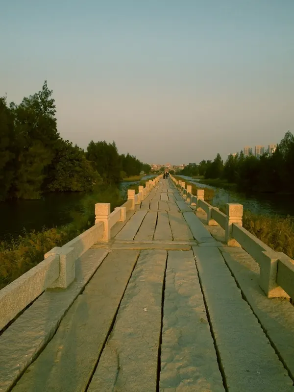 Stone deck and railings of Anping Bridge · 安平桥 Photograph date recorded by the source: 2010-12-30.
Anping Bridge安平桥
Anping Bridge stretches across the former tidal estuary between Anhai and Shuitou on granite beams laid over stone piers. Its extraordinary horizontal line is the main sight: follow how each heavy slab carries the path onwards…
Read the place guide →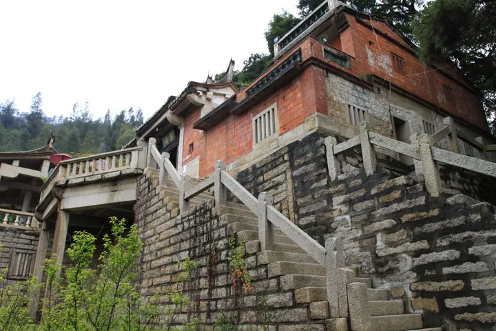 Cao'an temple hall and stone stairway, Jinjiang · 草庵大殿及石阶,晋江市 Source-recorded photograph date: 2012-02-29.
Cao'an Manichaean Temple草庵
A Song-founded shrine in Jinjiang, Quanzhou, rebuilt in stone in 1339, with a cliff-carved statue of Mani that is part of the Quanzhou World Heritage site.
Read the place guide →Plan your visit
Getting there
Jinjiang is about 15 km in a straight line from central Quanzhou. Search for 晋江市 in a map app to find stations and your accommodation.
Where to stay →Build your route
Wudianshi Historic District and Anping Bridge are both listed here. The linked place guides have entrance and visit details.
Continue with Quanzhou →More in Quanzhou
Sources & geographic information
Administrative names and parent areas: Official geographic directory · Reference date 2026-09-06.
Some facts checked against 晋江市 — Wikipedia contributors, CC BY-SA 4.0.
Photo: Wudianshi Historic District · Source photographer · License not provided. EXIF orientation normalized; resized without changing aspect ratio; converted to WebP. No subject edits.
Photo: Anping Bridge · Zania · CC BY-SA 3.0. Full frame retained; proportionally resized and converted to WebP. No retouching or changes to the photographed subject. Card displays may crop the view.

Photo: Cao'an Manichaean Temple · Zhangzhugang · CC BY-SA 4.0. Full frame retained; proportionally resized and converted to WebP. No retouching or changes to the photographed subject. Card displays may crop the view.

Map data © OpenStreetMap contributors. Pins mark approximate centres, not entrances or boundaries.