


Get to know Datian County
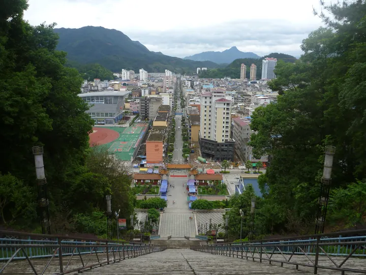
Photo adjustments
Full frame retained; proportionally resized and converted to WebP. No retouching or changes to the photographed subject. Card displays may crop the view.
- Administrative area
- County · 县
- Part of
- Sanming
- Chinese name
- 大田县
- Local areas
- County guide
Setting and landscape
Datian borders Dehua (德化县) to the east, Yongchun (永春县) to the south, Zhangping (漳平) to the south-west, Yong'an (永安市) to the west, Sanyuan District (三元区) to the north-west and Youxi (尤溪县) to the north. This is low and middle mountain country: 175 peaks top 1,000 m, the highest being Daxianfeng (大仙峰) at 1,553.4 m, while the county town sits at 350 m. Tributaries of the Min, Jiulong and Jin rivers rise here, and the main stream of the Junxi (均溪) runs 81.7 km within the county. Hot springs of 29–79 °C rise at five places, among them Guangtang (广汤) in Taoyuan (桃源镇) and Tangquan (汤泉) in Taihua (太华镇).
History
The county was created in 1535 under the Ming from parts of Youxi, Yong'an, Zhangping and Dehua, and placed under Yanping Prefecture (延平府). In 1734 it was transferred to Yongchun Prefecture (永春州). Datian came under Communist control on 6 September 1949 and has belonged to Sanming since the prefecture-level city was formed in 1983. Guo Jujing (郭居敬), compiler of the Twenty-Four Filial Exemplars (二十四孝), came from Datian.
What to see
Five buildings were listed together as the Datian earth forts (大田土堡群), a national key protected site, in 2013. Pipa Fort (琵琶堡) at Jianguo village in Jianshe (建设镇) is a mainly defensive fort begun in the Qianlong reign (1736–1795). Fanglian Fort (芳联堡) at Xusikeng village in Junxi (均溪镇) is a mansion-style fort begun in 1806, the same year as Anliang Fort (安良堡) in the She village of Dongban in Taoyuan. At Xiaohua village in Taihua, the square Tai'an Fort (泰安堡) and the mainly residential Guangchong Hall (广崇堂) both date from 1857.
The former site of the "Second Jimei School Village" (第二集美学村) is a national memorial site of the War of Resistance against Japan. Provincially protected sites include the Yindingban silver mine site (银丁坂银矿遗址), the Wenchang Pavilion at Guangping (广平文昌阁) and Zhendong Bridge (镇东桥).
Food and local products
The Datian bench-lantern dragon (大田板灯龙) and zaju zuochang opera (杂剧作场戏) are on the national intangible heritage list. The county is known as a home of Oriental Beauty tea (美人茶) and of high-mountain tea, with 70,000 mu of gardens suited to Oriental Beauty. Other local products are Datian rabbit, Zaoxing wind-dried camellia oil (早兴风吹茶油), Shanbao fermented greens (山宝糟菜) from Jianshe, Junxi nine-layer cake (均溪九层粿), Wuling snow-mountain radish (武陵雪山萝卜) and Meishan chillies (梅山福梅辣椒).
Highlights
- Datian earth forts 大田土堡群: Five Qing-dynasty fortified houses listed as a national key protected site in 2013.
- Anliang Fort 安良堡: Defensive fort with living quarters, begun in 1806, in the She village of Dongban, Taoyuan.
- Daxianfeng 大仙峰: Highest peak of the county at 1,553.4 m.
- Datian bench-lantern dragon 大田板灯龙: Dragon dance on the national intangible heritage list.
- Oriental Beauty tea 美人茶: Datian is named a home of this tea, with 70,000 mu of suitable gardens.
Sources for this guide
综合概况 _ 大田简介 _ 大田县人民政府门户网站 · Datian County People's Government
大田县历史沿革 _ 历史沿革 _ 大田县人民政府门户网站 · Datian County People's Government
自然地理 _ 自然地理 _ 大田县人民政府门户网站 · Datian County People's Government
大田县 - 维基百科,自由的百科全书 · Wikipedia (Chinese) · CC BY-SA 4.0
大田土堡群 - 维基百科,自由的百科全书 · Wikipedia (Chinese) · CC BY-SA 4.0
Original English written from the listed sources and checked sentence by sentence against quoted extracts by a separate reviewer. Updated 2026-09-23.
Explore Datian County
Core places to explore, with English and Chinese names.
Datian County 大田县
Plan your visit
Getting there
Datian County is about 60 km in a straight line from central Sanming. Search for 大田县 in a map app to find stations and your accommodation.
Where to stay →More in Sanming
Sources & geographic information
Administrative names and parent areas: Official geographic directory · Reference date 2026-09-06.
Some facts checked against 大田县 — Wikipedia contributors, CC BY-SA 4.0.
Some facts checked against 大田土堡群 — Wikipedia contributors, CC BY-SA 4.0.
Map data © OpenStreetMap contributors. Pins mark approximate centres, not entrances or boundaries.