


Get to know Qingliu County
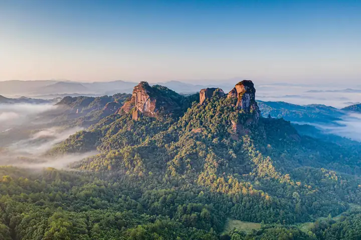
Photo adjustments
EXIF orientation normalized; resized without changing aspect ratio; converted to WebP. No subject edits.
- Administrative area
- County · 县
- Part of
- Sanming
- Chinese name
- 清流县
- Local areas
- County guide
Setting and landscape
The Jiulong Stream, in the upper Min River system, winds through the county town in an S-shaped bend that the county compares to a taiji diagram. Qingliu is a national hot-spring geopark with more than ten natural geothermal outlets; at Gaolai (高赖) the water emerges at up to 93°C, which the county lists as the hottest spring in Fujian, and the Tianfang Yuetan (天芳悦潭) resort stands there. Forest covers 80.2% of the county.
History
The county was created in 1098 under the Northern Song, after the judicial commissioner Wang Zudao (王祖道) proposed carving it out of Ninghua and Changting; it was abolished in 1228, restored in 1271, and belonged to Tingzhou (汀州) through the Qing. In January 1930 Mao Zedong wrote "Ru Meng Ling: New Year's Day" (如梦令·元旦) while camped at Linshe (林畲), and a county soviet government was set up in 1932. The county describes Yiyandi (诒燕第) in Tangku village (塘堀村), Linshe, as the best-preserved former residence of Mao in Fujian.
What to see
Jiulong Lake (九龙湖) in Shawu Township (沙芜乡) covers 128 square kilometres, 33 of them water, amid karst hills; the Jiulong caves (九龙洞群) in Baima Mountain (白马山) have about 1.5 kilometres of developed passages. Six fossil human lower molars collected in these caves in 1988 and 1989 were named "Qingliu Man" (清流人) by Chinese Academy of Sciences archaeologists, and the county names Fox Cave (狐狸洞) as Fujian's oldest human-fossil site.
Laifang village (赖坊村) is a national historic and cultural village with 106 old houses. On Lingtai Mountain (灵台山) in Changxiao town (长校镇), revered as a Hakka ancestral mountain, a 45.99-metre statue of Dingguang Gufo (定光古佛), protector of the Hakka, stands at the summit. Beidou Mountain (北斗山) has Danxia landforms, and Dafeng Mountain (大丰山) provincial forest park rises to 1,706 metres. At Huangboyang (黄泊洋) in Songxi town (嵩溪镇), the county protects an old volcanic crater and its basalt; at a disused quarry about 10 kilometres from Huangboyang, the cut hillside shows the basalt in vertical columns.
Food and local products
Qingliu yellow goat (清流黄羊), Qingliu cut flowers (清流鲜切花), Qingliu tofu skin (清流豆腐皮) and Qingliu stream fish (清流溪鱼) are Chinese geographical indication products. Among handicrafts, Qingliu is known for its scissors.
Getting oriented
The county government sits in Longjin town (龙津镇). Yong'an (永安) and Mingxi (明溪) lie to the east, Ninghua (宁化) to the west, and Liancheng (连城) and Changting (长汀) to the south. Qingliu was one of the eight Hakka counties of Ming and Qing Tingzhou.
Highlights
- Jiulong Lake 九龙湖: Karst lake area in Shawu Township with the Jiulong caves and the Qingliu Man fossil finds.
- Lingtai Mountain 灵台山: Hakka ancestral mountain in Changxiao town with a 45.99-metre Dingguang Gufo statue.
- Laifang village 赖坊村: National historic and cultural village with 106 old houses.
- Tianfang Yuetan hot spring 天芳悦潭温泉: Resort at Gaolai, where spring water emerges at up to 93°C.
- Qingliu tofu skin 清流豆腐皮: Chinese geographical indication product.
Sources for this guide
历史沿革 _ 清流县人民政府门户网站 · Qingliu County People's Government
清流: 海西休闲之都 温泉旅游胜地 · Qingliu County People's Government
九龙湖风景 · Qingliu County People's Government
风景名胜—嵩溪玄武岩 · Qingliu County People's Government
清流县 - 维基百科,自由的百科全书 · Wikipedia (Chinese) · CC BY-SA 4.0
Original English written from the listed sources and checked sentence by sentence against quoted extracts by a separate reviewer. Updated 2026-09-23.
Explore Qingliu County
Core places to explore, with English and Chinese names.
Places to explore around Qingliu County
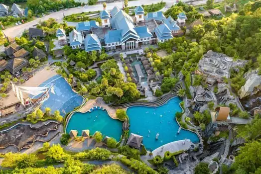 Tianfang Yuetan Hot Spring ·
 Plan your visit
Getting there
Qingliu County is about 85 km in a straight line from central Sanming. Search for 清流县 in a map app to find stations and your accommodation.
Where to stay →Build your route
Start with Tianfang Yuetan Hot Spring. The linked place guides have entrance and visit details.
Continue with Sanming →More in Sanming
Sources & geographic information
Administrative names and parent areas: Official geographic directory · Reference date 2026-09-06.
Some facts checked against 清流县 — Wikipedia contributors, CC BY-SA 4.0.
Photo: Tianfang Yuetan Hot Spring · Source photographer · License not provided. EXIF orientation normalized; resized without changing aspect ratio; converted to WebP. No subject edits.
Map data © OpenStreetMap contributors. Pins mark approximate centres, not entrances or boundaries.