


Get to know Mingxi County
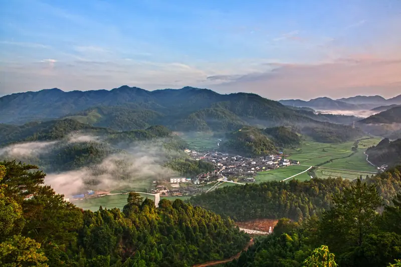
Photo adjustments
EXIF orientation normalized; resized without changing aspect ratio; converted to WebP. No subject edits.
- Administrative area
- County · 县
- Part of
- Sanming
- Chinese name
- 明溪县
- Local areas
- County guide
Area & population
- Area in the source
- 1,709.00 km²
- Population · 2020
- 98,930
Source: cited geographic source, as of the dates shown.
Setting and landscape
Mountains ring the county. The north-west and north-east rise to 700–1,000 m, 25 peaks top 1,000 m, and the highest, Shengshuiyan (圣水岩), reaches 1,561.4 m; the lowest ground, at 180 m, is the Yaoshe plain (瑶奢平原) in the south-east. The streams drain to two systems, the Shaxi (沙溪) and the Futun (富屯溪). The Junzifeng National Nature Reserve (君子峰国家级自然保护区) lies within the county, which sits on an international bird migration route: 345 wild bird species have been recorded, and Mingxi is called the home of Cabot's tragopan (黄腹角雉).
History
The county was created in 1470 as Guihua County (归化县) under Tingzhou Prefecture (汀州府), from parts of Qingliu, Ninghua, Jiangle and Sha counties, after the official Cheng Xi (程熙) argued that the area was remote and its people hard to govern. The Red Army took it in 1931, making it one of the 21 counties of the Central Soviet Area; it is the Guihua of Mao Zedong's poem "Ru Meng Ling: New Year's Day" (如梦令·元旦). More than 3,200 local people joined the Red Army, most of whom died in the Battle of the Xiang River; only 270 are remembered by name. In 1933 the county was renamed Mingxi because Guihua shared its name with Guihua city in Suiyuan. It was merged into Sanming County in 1956 and took back the Mingxi name in 1964. The county government states that Yang Shi (杨时), founder of Min learning, was born at Longhu village (龙湖村).
What to see
The Nanshan site (南山遗址), dated to 5,800–3,500 years ago, is described as the first prehistoric site found in Fujian that combines cave and open-air settlement. It is a national key protected site and was named one of China's six major archaeological discoveries of 2017. Revolutionary sites include the site of Mao Zedong's peasant survey meeting at Wanchun Bridge (万春桥), the Tongtieling battlefield (铜铁岭) of the Red Seventh Army Corps, and the Dishuiyan Red Army field hospital (滴水岩红军战地医院).
Food and local products
Mingxi is counted with Changle in Shandong, Liuhe in Jiangsu and Wenchang in Hainan as one of China's four sapphire-producing areas, and Mingxi sapphire is grouped with Shoushan stone (寿山石) and Hua'an jade (华安玉) as one of Fujian's famous stones. The county is also named a home of Chinese yam (淮山) and of the Chinese yew (红豆杉).
Getting oriented
The county seat is Xuefeng (雪峰镇). Sha County (沙县) lies to the east, Ninghua (宁化县) to the west, Yong'an (永安市) to the south and Jiangle (将乐县) to the north.
Highlights
- Nanshan site 南山遗址: Prehistoric cave and open-air site, 5,800–3,500 years old; one of China's six major archaeological discoveries of 2017.
- Junzifeng National Nature Reserve 君子峰国家级自然保护区: National nature reserve within the county.
- Shengshuiyan 圣水岩: Highest peak of the county at 1,561.4 m.
- Mingxi sapphire 明溪蓝宝石: Counted among China's four sapphire-producing areas and Fujian's famous stones.
Sources for this guide
明溪县概况 _ 明溪概况 _ 明溪县人民政府门户网站 · Mingxi County People's Government
历史沿革 _ 明溪县人民政府门户网站 · Mingxi County People's Government
自然地理 _ 明溪县人民政府门户网站 · Mingxi County People's Government
明溪县 - 维基百科,自由的百科全书 · Wikipedia (Chinese) · CC BY-SA 4.0
Original English written from the listed sources and checked sentence by sentence against quoted extracts by a separate reviewer. Updated 2026-09-23.
Explore Mingxi County
Core places to explore, with English and Chinese names.
Mingxi County 明溪县
Plan your visit
Getting there
Mingxi County is about 40 km in a straight line from central Sanming. Search for 明溪县 in a map app to find stations and your accommodation.
Where to stay →More in Sanming
Sources & geographic information
Administrative names and parent areas: Official geographic directory · Reference date 2026-09-06.
Some facts checked against 明溪县 — Wikipedia contributors, CC BY-SA 4.0.
Map data © OpenStreetMap contributors. Pins mark approximate centres, not entrances or boundaries.