


Get to know Youxi County
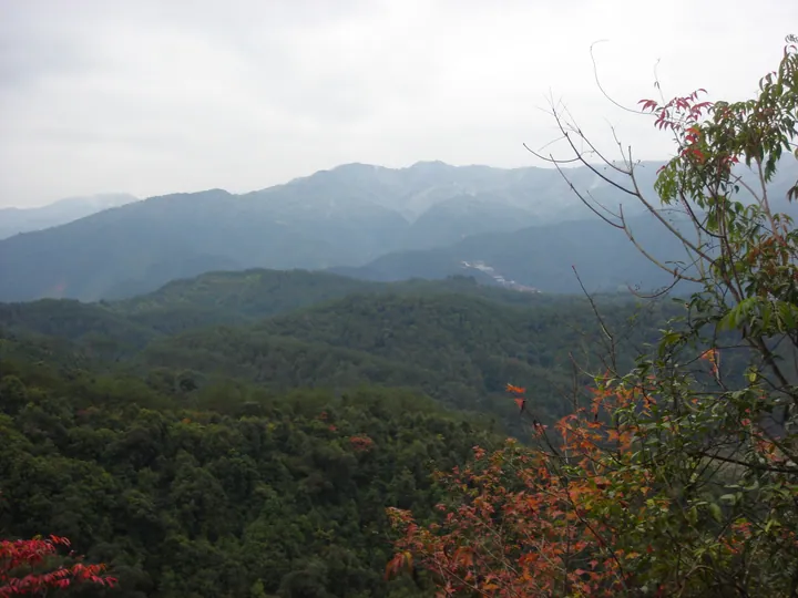
Photo adjustments
Full frame retained; proportionally resized and converted to WebP. No retouching or changes to the photographed subject. Card displays may crop the view.
- Administrative area
- County · 县
- Part of
- Sanming
- Chinese name
- 尤溪县
- Local areas
- County guide
Area & population
- Area in the source
- 3,425.00 km²
Source: cited geographic source, as of the dates shown.
Setting and landscape
The county describes its land as eight parts mountain, one part water and one part field, and forest covers 78.48%. The Jiemian Reservoir (街面水库) lies on the southern border with Datian (大田) and Dehua (德化). The county lists the Lianhe terraces (联合梯田) as Globally Important Agricultural Heritage. Youxi sits where the Eastern, Central and Southern Min and Puxian dialect areas meet, and its local dialects are hard to understand even for each other's speakers.
History
The county was founded in 741 under the Tang and was the first in Fujian to be named a "thousand-year-old county" by the UN place-name experts group. Zhu Xi's father, Zhu Song (朱松), became county sheriff in 1123 and, after leaving office, lodged in the house of a local man, Zheng Yizhai (郑义斋), below Gong Hill (公山) south of the county town; Zhu Xi (朱熹) was born there in 1130. Shrines to father and son were built on the site in 1237, and in 1253 Emperor Lizong granted it the name Nanxi Academy (南溪书院). Zhu Xi returned to Youxi nine times.
What to see
The county's five national 4A scenic areas are Tangchuan Xiatianxia (汤川侠天下), the Zhuzi Cultural Park (朱子文化园), the Guifeng old houses (桂峰古民居), Jiufu Mountain (九阜山) and Guxi Xinghe (古溪星河). Guifeng village (桂峰村), in a mountain valley at 550 metres in the north-east of Yangzhong town (洋中镇), is a national historic and cultural village whose residents all bear the surname Cai.
Youxi's earth fortresses (土堡) are defensive rural buildings with earth walls, corner towers, a running gallery for defenders, bamboo gun ports and water holes above stone gateways for putting out fires. Maojing fortress (茂荆堡) at Gaizhu village (盖竹村), Taixi Township (台溪乡), mixes southern Fujian, Fuzhou and Hakka building traditions.
Food and local products
Youxi kumquats (尤溪金柑) and Youxi green bamboo shoots (尤溪绿竹笋) hold Chinese geographical indication status, and the county calls itself a home of kumquats, bamboo and tea-oil camellia. Local foods include Meixian meat guangbing (梅仙肉光饼), Shuidong pressed duck (水东板鸭) and Youxi thick noodles (尤溪大条面).
Getting oriented
Minqing (闽清) and Yongtai (永泰) lie to the east, Datian and Shaxian (沙县) to the west, Dehua to the south and Yanping District (延平区) of Nanping to the north. The Fuzhou–Yinchuan (福银), Shaxian–Xiamen (沙厦) and Puyan (莆炎) expressways and the Nanchang–Fuzhou railway (昌福铁路) pass through the county.
Highlights
- Nanxi Academy 南溪书院: Birthplace of Zhu Xi in 1130; named by Emperor Lizong in 1253.
- Guifeng village 桂峰村: National historic and cultural village at 550 metres in the north-east of Yangzhong town.
- Lianhe terraces 联合梯田: Terraced fields listed by the county as Globally Important Agricultural Heritage.
- Maojing fortress 茂荆堡: Earth fortress mixing southern Fujian, Fuzhou and Hakka building traditions.
- Youxi kumquat 尤溪金柑: Chinese geographical indication product.
Sources for this guide
尤溪概貌 _ 尤溪概况 _ 尤溪县人民政府门户网站 · Youxi County People's Government
南溪书院 · Youxi County People's Government (Zhu Xi Culture Research Society)
历史文化名村 · Youxi County People's Government
尤溪土堡 · Youxi County People's Government
尤溪县 - 维基百科,自由的百科全书 · Wikipedia (Chinese) · CC BY-SA 4.0
Original English written from the listed sources and checked sentence by sentence against quoted extracts by a separate reviewer. Updated 2026-09-23.
Explore Youxi County
Core places to explore, with English and Chinese names.
Places to explore around Youxi County
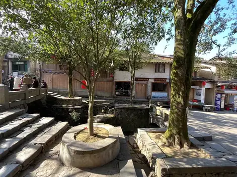 Guifeng Old Village ·
 Plan your visit
Getting there
Youxi County is about 55 km in a straight line from central Sanming. Search for 尤溪县 in a map app to find stations and your accommodation.
Where to stay →Build your route
Start with Guifeng Old Village. The linked place guides have entrance and visit details.
Continue with Sanming →More in Sanming
Sources & geographic information
Administrative names and parent areas: Official geographic directory · Reference date 2026-09-06.
Some facts checked against 尤溪县 — Wikipedia contributors, CC BY-SA 4.0.
Photo: Guifeng Old Village · Source photographer · License not provided. EXIF orientation normalized; resized without changing aspect ratio; converted to WebP. No subject edits.
Map data © OpenStreetMap contributors. Pins mark approximate centres, not entrances or boundaries.