


Get to know Jingtai County
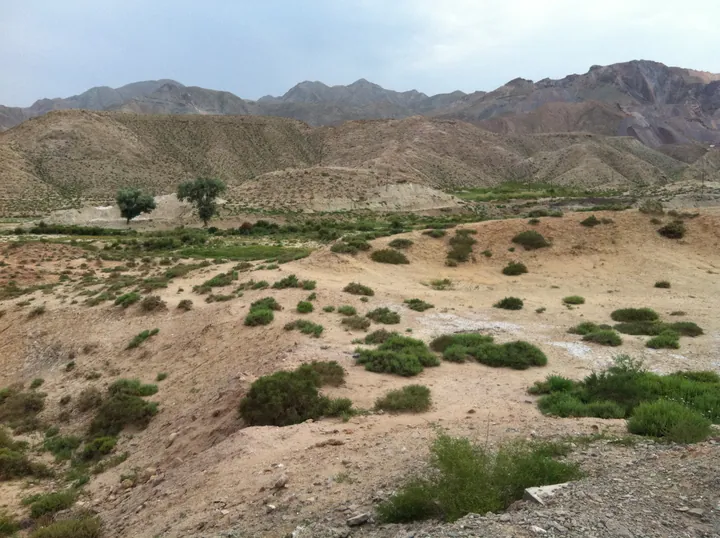
Photo adjustments
Full frame retained; proportionally resized and converted to WebP. No retouching or changes to the photographed subject. Card displays may crop the view.
- Administrative area
- County · 县
- Part of
- Baiyin
- Chinese name
- 景泰县
- Local areas
- County guide
Area & population
- Area in the source
- 5,483.00 km²
- Population · 2019
- 238,900
- Administrative seat
- Yitiaoshan
Source: cited geographic source, as of the dates shown.
Setting and landscape
The land is higher in the south-west and lower in the north-east, from 3,321 metres down to 1,276 metres, with Shoulu Mountain (寿鹿山) in the north-west. Jingyuan County (靖远县) and Pingchuan District (平川区) face it across the Yellow River to the east; Alxa Left Banner (阿拉善左旗) in Inner Mongolia and Zhongwei (中卫) in Ningxia lie to the north, and Gulang (古浪县) and Tianzhu (天祝藏族自治县) to the west.
The arid Jingtaichuan (景泰川) upland sits 400 to 600 metres above the river. The Jingtaichuan Electric Lifting Irrigation Project (景泰川电力提灌工程) was proposed in July 1968; it waters 800,000 mu of desertified land in Jingtai and Gulang, and the county government hails it as "China's foremost" (中华之最).
History
Emperor Xuan of the Han set up Aowei County (媪围县) here, which later became the ancient city of Diaogou (吊沟). Mongol Tatars held the land west of the Yellow River before the mid-Ming; Li Wen (李汶) and Tian Le (田乐) built over 180 li of Great Wall here, and Tian Le drove the Tatars out in 1598. Forts here included Hongshui (红水堡) and Yongtai. Hongshui County was split from Gaolan (皋兰县) in 1913, and the county has carried the name Jingtai since 1933; the name means "thriving scenery, a peaceful country".
What to see
The Yellow River Stone Forest (黄河石林) became a national geopark in January 2004 and is a 4A scenic area. Of its roughly 50 square kilometres, 10 are an ancient stone forest formed in sandy conglomerate beds 2.1 million years ago, with pillars mostly 80 to 100 metres high and some reaching 200 metres. Here the Yellow River bends to flow from east to west, and the river has built up the Longwan oasis, with century-old jujube groves. Longwan village (龙湾村) is a listed Chinese traditional village where over a hundred households work sheepskin rafts (羊皮筏子).
Yongtai Fortress (永泰古城), 27 km from the county town in Sitan township (寺滩乡), was built in 1606–1608 under Li Wen; its tortoise-like outline gives it the name "tortoise city", and it became a national key protected site in 2006. Rammed-earth walls stand 8 to 12 metres high, the wells inside were dug by the Qing general Yue Zhongqi (岳钟琪), and the Gothic-style Republican-era Yongtai Primary School is now a museum branch. Shoulushan National Forest Park lies 39 km from the county town at an average altitude of 2,800 metres.
Getting oriented
The Dingbian–Wuwei Expressway (G2012) and the Lanzhou–Yingpanshui Expressway (S1) cross the county.
Highlights
- Yellow River Stone Forest 黄河石林: National geopark since 2004, with sandy-conglomerate pillars up to 200 metres beside a bend of the Yellow River.
- Yongtai Fortress 永泰古城: Ming fortress built 1606–1608, called the tortoise city; national key protected site since 2006.
- Longwan Village 龙湾村: Listed Chinese traditional village with jujube groves and sheepskin rafts.
- Jingtaichuan Electric Lifting Irrigation Project 景泰川电力提灌工程: Irrigation scheme watering 800,000 mu of desertified land in Jingtai and Gulang.
Sources for this guide
景泰风景名胜 · Jingtai County People's Government
戈壁古邑·永泰龟城|来白银,邂逅一段千年边塞时光 · Baiyin Municipal People's Government
一石一河一村——黄河石林的“留量”密码 · Baiyin Municipal People's Government
景泰县 - 维基百科,自由的百科全书 · Wikipedia (Chinese) · CC BY-SA 4.0
Jingtai County - Wikipedia · Wikipedia (English) · CC BY-SA 4.0
永泰城址 - 维基百科,自由的百科全书 · Wikipedia (Chinese) · CC BY-SA 4.0
黄河石林 - 维基百科,自由的百科全书 · Wikipedia (Chinese) · CC BY-SA 4.0
Original English written from the listed sources and checked sentence by sentence against quoted extracts by a separate reviewer. Updated 2026-09-23.
Explore Jingtai County
Core places to explore, with English and Chinese names.
Places to explore around Jingtai County
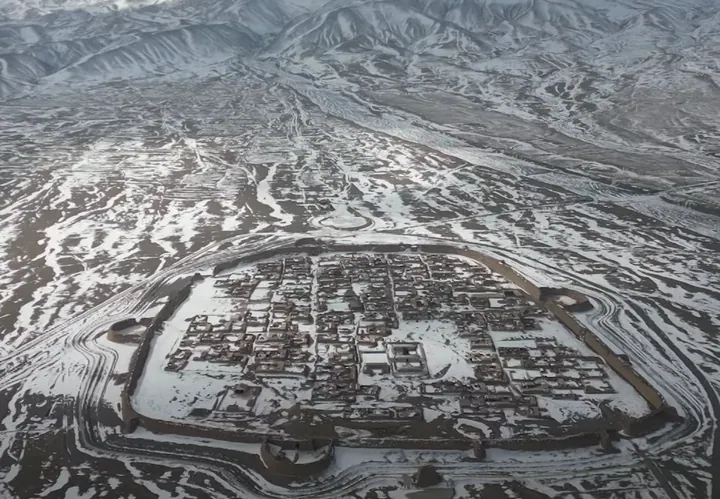 Aerial view of Yongtai Fortress, the snow-covered walled 'turtle city' in Jingtai County · 永泰古城航拍,白雪覆盖的龟城 Source-recorded photograph date: 2023-02-25.
Yongtai Fortress永泰古城
Yongtai is a Ming military settlement enclosed by substantial rammed-earth walls on the dry plateau. Its outline led to the nickname Turtle City, with the south gate and projecting barbican suggesting the head. Passing that…
Read the place guide →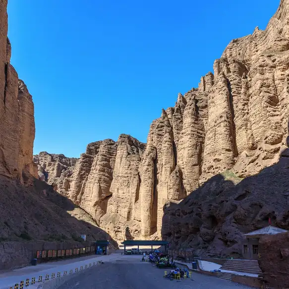 Yellow River Stone Forest · 黄河石林正规开放区
Yellow River Stone Forest黄河石林正规开放区
Huanghe Shilin (黄河石林), the Yellow River Stone Forest, is a national geological park and national 4A-rated scenic area at Longwan village, Zhongquan town, Jingtai County, Baiyin, Gansu, where yellow conglomerate stone peaks and columns stand above a bend of the Yellow River.
Read the place guide →Plan your visit
Getting there
Jingtai County is about 70 km in a straight line from central Baiyin. Search for 景泰县 in a map app to find stations and your accommodation.
Where to stay →Build your route
Yongtai Fortress and Yellow River Stone Forest are both listed here. The linked place guides have entrance and visit details.
Continue with Baiyin →More in Baiyin
Sources & geographic information
Administrative names and parent areas: Official geographic directory · Reference date 2026-09-06.
Some facts checked against 景泰县 — Wikipedia contributors, CC BY-SA 4.0.
Some facts checked against Jingtai County — Wikipedia contributors, CC BY-SA 4.0.
Some facts checked against 永泰城址 — Wikipedia contributors, CC BY-SA 4.0.
Some facts checked against 黄河石林 — Wikipedia contributors, CC BY-SA 4.0.
Photo: Yongtai Fortress · China News Service · 中国新闻社 · CC BY 4.0. Full frame retained; proportionally resized and converted to WebP. No retouching or changes to the photographed subject. Card displays may crop the view.

Photo: Yellow River Stone Forest · Source photographer · License not provided. EXIF orientation normalized; resized without changing aspect ratio; converted to WebP. No subject edits.
Map data © OpenStreetMap contributors. Pins mark approximate centres, not entrances or boundaries.