


Get to know Chongxin County
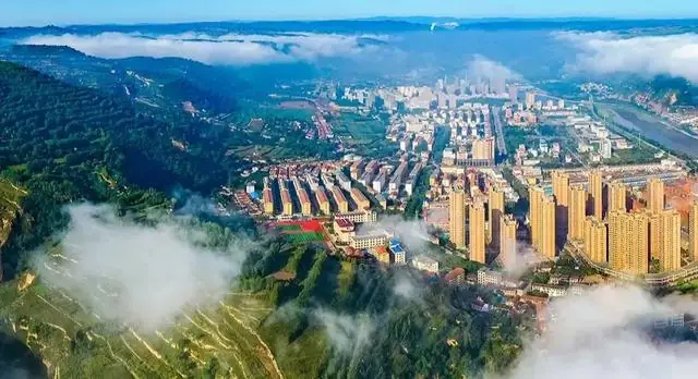
Photo adjustments
EXIF orientation normalized; resized without changing aspect ratio; converted to WebP. No subject edits.
- Administrative area
- County · 县
- Part of
- Pingliang
- Chinese name
- 崇信县
- Local areas
- County guide
Area & population
- Area in the source
- 850.00 km²
- Population · 2019
- 104,800
- Administrative seat
- Jinping
Source: cited geographic source, as of the dates shown.
Setting and landscape
The land rises from 1,085 to 1,728 metres, and the climate is warm-temperate, semi-arid and continental, with a mean annual temperature of 10.6°C. The county is known for old trees: a Chinese scholar tree about 3,200 years old called the Huaxia Ancient Pagoda Tree King (华夏古槐王), the unusual Sanyi cypress (三异柏) and a suoluo tree (娑罗树).
History
More than 3,000 years ago Gong Liu (公刘), an ancestor of the Zhou, led his people to settle at Ruiju (芮鞫), which the county government identifies with today's Chongxin; 26 sites of ancient cultures, among them Yangshao and Qijia remains, have been found in the county. The name comes from the Tang general Li Yuanliang (李元谅), military governor of Longyou and Prince of Wukang, who built a walled town here and stationed troops against the Tibetan empire (吐蕃). The county itself was founded in 963, the fourth year of the Northern Song Jianlong reign. The Temple of Prince Wukang (武康王庙) is a national key protected site.
What to see
Longquan Temple (龙泉寺) is a national 4A tourist area, and the ancient pagoda tree is one of six 3A areas. Wulong Mountain (五龙山) is a provincial scenic area and forest park, and Longze Lake (龙泽湖) is a national water-conservancy scenic area.
Xianziqiang (弦子腔), also called xiaoquzi or old meihu, is a local opera over 200 years old, led by the three-stringed sanxian and sung in a high voice, mostly telling historical tales and legends; it entered Pingliang's first intangible heritage list in June 2007. On the fifteenth night of the first lunar month, couples married the year before visit the bride's family for "lighting lamps and carrying the monkey" (点灯背猴): lamps and a monkey figure are moulded from jiugu flour (酒谷面) mixed with a little wheat flour. The lamps are lit, then grabbed by the crowd, and the new son-in-law carries the monkey home. The custom joined Gansu's fourth provincial intangible heritage list in February 2017.
Getting oriented
Chongxin borders Jingchuan (泾川) and Lingtai (灵台) counties to the east, Huating (华亭市) to the west, Kongtong District (崆峒区) of Pingliang to the north and Long County (陇县) in Shaanxi to the south.
Highlights
- Longquan Temple 龙泉寺: National 4A tourist area.
- Huaxia Ancient Pagoda Tree King 华夏古槐王: A scholar tree about 3,200 years old; a 3A tourist area.
- Temple of Prince Wukang 武康王庙: National key protected heritage site.
- Xianziqiang 弦子腔: Local sanxian-led opera, on Pingliang's first intangible heritage list (2007).
- Lighting lamps and carrying the monkey 点灯背猴: Lantern Festival custom with lamps of millet dough; provincial intangible heritage since 2017.
Explore Chongxin County
Core places to explore, with English and Chinese names.
Chongxin County 崇信县
Plan your visit
Getting there
Chongxin County is about 45 km in a straight line from central Pingliang. Search for 崇信县 in a map app to find stations and your accommodation.
Where to stay →More in Pingliang
Sources & geographic information
Administrative names and parent areas: Official geographic directory · Reference date 2026-09-06.
Map data © OpenStreetMap contributors. Pins mark approximate centres, not entrances or boundaries.