


Get to know Jingchuan County
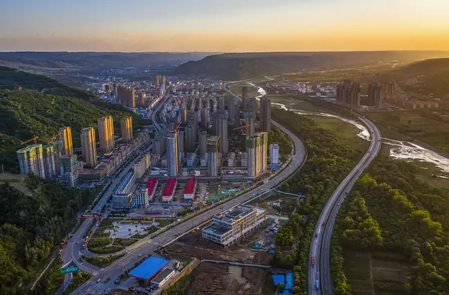
Photo adjustments
EXIF orientation normalized; resized without changing aspect ratio; converted to WebP. No subject edits.
- Administrative area
- County · 县
- Part of
- Pingliang
- Chinese name
- 泾川县
- Local areas
- County guide
Area & population
- Area in the source
- 1,409.30 km²
- Population · 2020
- 356,200
- Administrative seat
- Chengguan
Source: cited geographic source, as of the dates shown.
Setting and landscape
The county lies between 930 and 1,460 metres above sea level, with a mean annual temperature of 10.4°C, about 555 mm of rain and a frost-free season of 174 days. The Ministry of Agriculture includes it in the best-suited zone for quality apples, and most of the crop is Fuji; persimmons, carrots and cabbage are also grown. Since 1983 Jingchuan has been a model county for reforesting the Loess Plateau and it is a key county of the Three-North Shelter Forest Program.
History
The county government dates human life here to the Palaeolithic, about 400,000 years ago, and counts more than 2,100 years of commanderies and counties. The Han set up Anding County (安定县) here; the Tang renamed it Baoding (保定县) and the Jin named it Jingchuan. It was later absorbed into Jingzhou (泾州), became Jingzhou County in 1913 and went back to the name Jingchuan in 1914, which also avoided confusion with Jing County (泾县) in Anhui.
As Jingzhou, the town was the seat of a prefecture. Its old city, begun in the Western Han and abandoned in the early Ming, lies near the present county seat, and parts of it survive. Local culture draws on the Queen Mother of the West (西王母), Buddhism and the Ruan (阮氏) and Wanyan (完颜) clans; Wanyan Chenglin (完颜承麟), the last emperor of the Jin, is among the historical figures linked to the county.
What to see
The county names three main sights: the Queen Mother Palace on Hui Hill (回山王母宫), Dayun Temple (大云寺) and the Wangmugong Grottoes (王母宫石窟). The grottoes date from the Northern Wei and are a national key protected site in the cave-temple and stone-carving category.
Getting oriented
China National Highway 312, the G22 Qingdao–Lanzhou Expressway and the Xi'an–Pingliang railway all pass through the county.
Highlights
- Wangmugong Grottoes 王母宫石窟: Northern Wei cave temple, a national key protected site.
- Queen Mother Palace on Hui Hill 回山王母宫: Named by the county government as one of its main sights.
- Dayun Temple 大云寺: Buddhist temple named by the county as one of its main sights.
Sources for this guide
泾川概况 · Jingchuan County People's Government
王母宫石窟 - 维基百科,自由的百科全书 · Wikipedia (Chinese) · CC BY-SA 4.0
泾川县 - 维基百科,自由的百科全书 · Wikipedia (Chinese) · CC BY-SA 4.0
Jingchuan County - Wikipedia · Wikipedia (English) · CC BY-SA 4.0
Original English written from the listed sources and checked sentence by sentence against quoted extracts by a separate reviewer. Updated 2026-09-23.
Explore Jingchuan County
Core places to explore, with English and Chinese names.
Places to explore around Jingchuan County
 AI illustration · AI
 Plan your visit
Getting there
Jingchuan County is about 70 km in a straight line from central Pingliang. Search for 泾川县 in a map app to find stations and your accommodation.
Where to stay →Build your route
Start with Dayun Temple and Queen Mother Palace. The linked place guides have entrance and visit details.
Continue with Pingliang →More in Pingliang
Sources & geographic information
Administrative names and parent areas: Official geographic directory · Reference date 2026-09-06.
Some facts checked against 王母宫石窟 — Wikipedia contributors, CC BY-SA 4.0.
Some facts checked against 泾川县 — Wikipedia contributors, CC BY-SA 4.0.
Some facts checked against Jingchuan County — Wikipedia contributors, CC BY-SA 4.0.
Map data © OpenStreetMap contributors. Pins mark approximate centres, not entrances or boundaries.