


Get to know Zhuanglang County
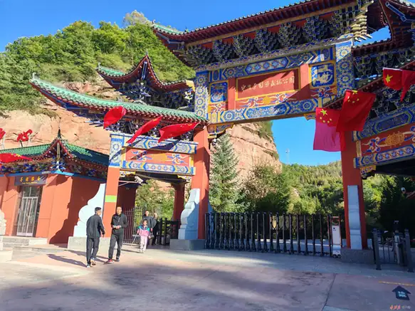
Photo adjustments
EXIF orientation normalized; resized without changing aspect ratio; converted to WebP. No subject edits.
- Administrative area
- County · 县
- Part of
- Pingliang
- Chinese name
- 庄浪县
- Local areas
- County guide
Area & population
- Area in the source
- 1,553.14 km²
- Population · 2019
- 453,120
- Administrative seat
- Shuiluo
Source: cited geographic source, as of the dates shown.
Setting and landscape
The land rises from south-west to north-east. The Liupan range forms the county's eastern edge and the boundary with Jingyuan (泾源) and Huating (华亭), running for about 100 km, and every other hill in the county is an offshoot of it. The highest point is Taomu Mountain (桃木山) at 2,857 m; the lowest, at 1,405 m, lies on the lower Hulu River (葫芦河). According to the county government, loess hills and gullies make up 63.3 per cent of the land, bare bedrock mountains 32 per cent and flat valley floors only 4.7 per cent, cut into 402 ridges and 2,500 gullies.
Most people farm, growing wheat and potatoes on terraced hills.
History
The oldest surviving local place name is Shuiluo (水洛). It first appears in 411, when the Western Qin attacked a Later Qin governor at Shuiluo city, and in 530 the rebel leader Wang Qingyun (王庆云) proclaimed himself emperor there. Shuiluo is still the name of the county seat. Under the Western Han, Jiequan County (街泉县), abolished in 74, had its seat at today's Handian (韩店), in the south-east of the county.
The name Zhuanglang dates from the Mongol conquest. In 1227 Genghis Khan attacked the Jingning, Longde and Zhuanglang area and spent the summer in the Liupan Mountains shortly before his death, and at about that time a Zhuanglang circuit was set up with its seat at Nanhu (南湖). It became a prefecture in 1304 and was reduced to a county in 1375. The county was merged into Longde in 1778, restored in 1913, merged into Jingning in 1958 and restored again in 1961.
What to see
Yunya Temple (云崖寺) is the centrepiece of a protected forest park in the far east of the county, about 40 km from the county town. In the county town itself, a monument records the "Zhuanglang Spirit" with which the county's farmers terraced all available hillside, work for which they were praised in the 1980s.
Highlights
- Yunya Temple 云崖寺: Temple in a protected forest park in the far east of the county, about 40 km from the county town.
- Shuiluo 水洛: County seat whose name is first recorded in 411, the oldest surviving place name in the county.
- Taomu Mountain 桃木山: Highest point of the county at 2,857 m, on the Liupan range.
Sources for this guide
地理概况 · Zhuanglang County People's Government
历史沿革 · Zhuanglang County People's Government
庄浪县 - 维基百科,自由的百科全书 · Wikipedia (Chinese) · CC BY-SA 4.0
Zhuanglang County - Wikipedia · Wikipedia (English) · CC BY-SA 4.0
Original English written from the listed sources and checked sentence by sentence against quoted extracts by a separate reviewer. Updated 2026-09-23.
Explore Zhuanglang County
Core places to explore, with English and Chinese names.
Zhuanglang County 庄浪县
Plan your visit
Getting there
Zhuanglang County is about 70 km in a straight line from central Pingliang. Search for 庄浪县 in a map app to find stations and your accommodation.
Where to stay →More in Pingliang
Sources & geographic information
Administrative names and parent areas: Official geographic directory · Reference date 2026-09-06.
Some facts checked against 庄浪县 — Wikipedia contributors, CC BY-SA 4.0.
Some facts checked against Zhuanglang County — Wikipedia contributors, CC BY-SA 4.0.
Map data © OpenStreetMap contributors. Pins mark approximate centres, not entrances or boundaries.