


Get to know Liangqing District
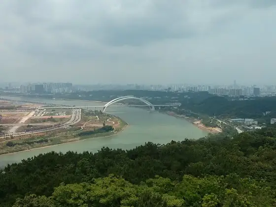
Photo adjustments
Resized and WebP compressed; subject not altered.
- Administrative area
- District · 市辖区
- Part of
- Nanning
- Chinese name
- 良庆区
- Local areas
- District guide
Area & population
- Area in the source
- 1,369.00 km²
- Population · 2020
- 323,200
Source: cited geographic source, as of the dates shown.
Setting and landscape
Qingxiu District (青秀区) faces Liangqing across the Yong River to the north; Yongning District (邕宁区) is to the east, Jiangnan District (江南区) to the west, and Shangsi County (上思县) and Qinbei District (钦北区) to the south. The land sits in the southern Nanning basin, high in the south and low in the north. Dongjian Mountain (岽尖山), 509.1 m high and described by the district gazetteer as the highest peak of the urban area, feeds the Fengting River reservoir. The Bachi River (八尺江) winds 110 km through Datang (大塘), Nachen (那陈), Nama (那马) and Liangqing towns; the district gazetteer explains its name, "eight-chi river", by its narrowest dry-season stretch, only eight chi across.
History
The Shichuantou site (石船头遗址) below Musan Ridge in Nahuang village (那黄村) was confirmed in 1963 and 1977 as a place of late Neolithic human activity some four to five thousand years old, with pottery shards and stone tools. From 1914 the area belonged to Yongning County (邕宁县); on 18 March 2005 that county was replaced by Yongning and Liangqing districts, with Liangqing taking the towns of Liangqing, Nama, Datang, Nachen and Nanxiao (南晓). Three academies were built here between 1882 and 1891: Nanbin (南斌书院), Jiafeng (甲峰书院) and Sanguan (三官书院).
Liaoluo folk song (嘹啰山歌), a two-part song of the Zhuang villages dating from the Ming, was collected by artists in 1995 and went on to the Nanning International Folk Song Arts Festival, and in 2013 Liangqing was named China's home of Liaoluo folk song. Other local traditions include tea-picking opera (采茶戏), Shigong opera (师公戏), the turtle-dove dance (斑鸠舞) and the Zhuang incense dragon dance (壮族香火龙舞).
What to see
The district's two 4A scenic areas are the Guangxi Planning Exhibition Hall (广西规划馆) and Wuxiang Lake Park (五象湖公园). Its 3A-rated sites include the Nanning Museum (南宁博物馆), the Guangxi Art Museum (广西美术馆), the Guangxi Culture and Art Centre (广西文化艺术中心) and the Dawangtan scenic area (大王滩风景区); other named sights are Fengting Lake (凤亭湖) and the cliff inscriptions on Leimao Ridge (蕾帽岭摩崖石刻). The mist on Wuxiang Ridge (五象岭) was counted among the old Eight Views of Nanning.
Highlights
- Wuxiang Lake Park 五象湖公园: 4A scenic area listed by the district gazetteer.
- Nanning Museum 南宁博物馆: 3A-rated city museum in the district.
- Shichuantou site 石船头遗址: Late Neolithic site in Nahuang village, four to five thousand years old.
- Liaoluo folk song 嘹啰山歌: Two-part Zhuang folk song; Liangqing was named its home in 2013.
Sources for this guide
良庆概貌_广西南宁市良庆区人民政府 (区位优势) · Liangqing District Local Chronicles Committee (Liangqing District People's Government)
良庆概貌_广西南宁市良庆区人民政府 (历史沿革) · Liangqing District Local Chronicles Committee (Liangqing District People's Government)
良庆概貌_广西南宁市良庆区人民政府 (自然资源) · Liangqing District Local Chronicles Committee (Liangqing District People's Government)
良庆概貌_广西南宁市良庆区人民政府 (历史人文) · Liangqing District Local Chronicles Committee (Liangqing District People's Government)
Original English written from the listed sources and checked sentence by sentence against quoted extracts by a separate reviewer. Updated 2026-09-24.
Explore Liangqing District
Core places to explore, with English and Chinese names.
Liangqing District 良庆区
Plan your visit
Getting there
Liangqing District is about 8 km in a straight line from central Nanning. Search for 良庆区 in a map app to find stations and your accommodation.
Where to stay →More in Nanning
Sources & geographic information
Administrative names and parent areas: Official geographic directory · Reference date 2026-09-06.
Map data © OpenStreetMap contributors. Pins mark approximate centres, not entrances or boundaries.