


Get to know Xixiangtang District
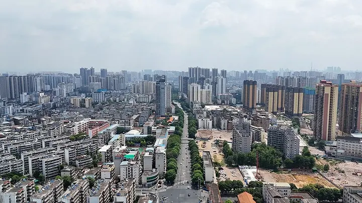
Photo adjustments
Full frame retained; proportionally resized and converted to WebP. No retouching or changes to the photographed subject. Card displays may crop the view.
- Administrative area
- District · 市辖区
- Part of
- Nanning
- Chinese name
- 西乡塘区
- Local areas
- District guide
Area & population
- Area in the source
- 1,154.00 km²
- Population · 2020
- 1,262,600
Source: cited geographic source, as of the dates shown.
Setting and landscape
The district lies south of the Tropic of Cancer on hills and terraces, and the Zuo (左江), You (右江) and Yong rivers all pass through it. The climate is south-subtropical and monsoonal: warm, humid and rainy, with little frost and no snow.
Luoxiu Mountain (罗秀山) in the northwest takes its name from Luo Xiu (罗秀), a Western Jin Taoist said to have become an immortal there. The Nanning prefectural gazetteer records the Eastern Jin alchemist Ge Hong (葛洪) making elixirs on the mountain, and the district government says the Huixin edition of the Platform Sutra (六祖坛经), a key Chan Buddhist text, was compiled there.
History
In 1381 Xuanhua County (宣化县) created a western rural district called Xixiang, "west countryside". Relay stations on the routes west from Nanning were called pu under the Ming and renamed tang in the early Qing. The second station on the water route, Xixiang Ertang (西乡二塘) at the old Xixiangtang street, came to be called Xixiangtang, and the district is named after it. The traveller Xu Xiake (徐霞客) reached Nanning in the eighth month of 1637 and spent nearly a month around Shuijie (水街), praising its food; the diary he kept is the only complete surviving account of his Nanning visit.
What to see
Shuijie is called the first street of Nanning's opening as a trading port, and the century-old Yuedong Guild Hall (粤东会馆) is known as the port's merchant hall. The Huang family houses (黄氏家族民居) and Chendong old village (陈东老村) represent the dwellings of Nanning's native residents. Other sights include the Longmen Shuidu (龙门水都) scenic area, Nanning Zoo, Luxianshan leisure sports park (芦仙山), Tangren cultural park (唐人文化园) in converted factory buildings, and Zhongliang (忠良村) in the Meili Nanfang (美丽南方) area, a national key rural-tourism village.
Guangxi University (广西大学), described by the district as the oldest and largest comprehensive university in Guangxi, is here, as are Guangxi Minzu University (广西民族大学) and the Guangxi Academy of Sciences.
Food and local products
The district's farm specialities include Shuangding "dingha" pigeons (双定顶哈鸽), Jinling chickens (金陵鸡), Tanluo (坛洛) pigs, citrus and Wanda bitter melon (万大苦瓜).
Getting oriented
Xixiangtang faces Jiangnan District (江南区) across the Yong River to the south and borders Xingning (兴宁区) to the east, Long'an (隆安) and Fusui (扶绥) to the west and Wuming (武鸣) to the north. Nanning Railway Station, Nanning West high-speed station and the terminals of metro lines 1, 2 and 3 are in the district, and Jiangbei Avenue (江北大道) runs for nearly 20 kilometres across it.
Highlights
- Shuijie 水街: Century-old street called the first street of Nanning's opening as a port; Xu Xiake praised its food in 1637.
- Yuedong Guild Hall 粤东会馆: Century-old merchant guild hall of the Nanning trading port.
- Luoxiu Mountain 罗秀山: Named after a Western Jin Taoist; linked to Ge Hong and the Huixin edition of the Platform Sutra.
- Chendong old village 陈东老村: Represents the dwellings of Nanning's native residents.
- Guangxi University 广西大学: Described as Guangxi's oldest and largest comprehensive university.
Sources for this guide
西乡塘区概况_西乡塘概况_广西南宁市西乡塘区人民政府 · Xixiangtang District People's Government, Nanning
西乡塘区地理位置与建置沿革_历史沿革_广西南宁市西乡塘区人民政府 · Xixiangtang District Yearbook (Xixiangtang District People's Government portal)
Original English written from the listed sources and checked sentence by sentence against quoted extracts by a separate reviewer. Updated 2026-09-24.
Explore Xixiangtang District
Core places to explore, with English and Chinese names.
Xixiangtang District 西乡塘区
Plan your visit
Getting there
Xixiangtang District is about 3 km in a straight line from central Nanning. Search for 西乡塘区 in a map app to find stations and your accommodation.
Where to stay →More in Nanning
Sources & geographic information
Administrative names and parent areas: Official geographic directory · Reference date 2026-09-06.
Map data © OpenStreetMap contributors. Pins mark approximate centres, not entrances or boundaries.