


Get to know Yongning District
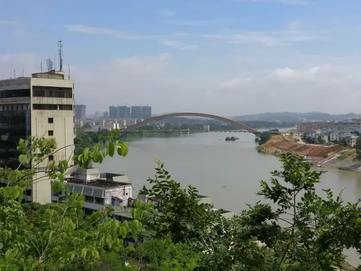
Photo adjustments
Full frame retained; proportionally resized and converted to WebP. No retouching or changes to the photographed subject. Card displays may crop the view.
- Administrative area
- District · 市辖区
- Part of
- Nanning
- Chinese name
- 邕宁区
- Local areas
- District guide
Area & population
- Administrative seat
- Pumiao
Source: cited geographic source, as of the dates shown.
History
Yongning traces its founding to AD 318, the first year of the Daxing era of the Eastern Jin, when Jinxing County (晋兴县) was set up; the district government quotes an old Nanning saying that "first there was Yongning, then Nanning" (先有邕宁,后有南宁). The name Yongning County dates from 1914, when the former Nanning County was renamed, with its seat in Nanning city. In March 2005, in a redrawing of Nanning's districts, the county was abolished and Yongning District was created along with Liangqing, Qingxiu and Jiangnan districts.
What to see
The best-known site is the Dingsishan shell midden (顶蛳山贝丘遗址), a Neolithic site that the district government counts among the largest and richest of its kind in Guangxi. It was named one of China's ten major archaeological discoveries of 1997 and is a nationally protected site; the Dingsishan Site Museum is rated a national second-class museum. Other old sites are the Qing-dynasty Wusheng Palace (五圣宫), the Leipoling cliff inscriptions (雷婆岭摩崖石刻) and the old opera stage at Nalian (那莲古戏台). The Pumiao Old Street (蒲庙老街) historic block is covered by Nanning's historic-city conservation plan.
Nanning Garden Expo Park (南宁园博园) and Pujin Park (蒲津公园) are rated 4A scenic areas. Pujin Park holds a 9.98-metre stone statue of the God of Wealth, which the district government lists as the tallest in Guangxi. Namengpo (那蒙坡) in Naliang village is on the fifth national list of traditional Chinese villages.
Festivals, food and local products
Yongning is largely Zhuang, and in 2013 the China Folk Literature and Art Association named it a home of Zhuang bayin (八音) ensemble music. Pumiao marks the anniversary of its market's founding on the 12th day of the third lunar month with the Huapo Festival (花婆节), honouring Huapo, the legendary founder of the market.
Pumiao is known for raw-pressed rice noodles (生榨米粉), which have a light sourness from yeast that forms while the noodles are made. Baiji (百济) sesame duck, named for the small size of the bird, is stewed, sliced and dressed with lemon, sour plum and sugar. Five-colour glutinous rice (五色糯米饭), Nalian rolled rice noodles (那莲卷筒粉) and iron-pan sesame cakes (铁锅芝麻饼) are sold as street food. Nalou yam (那楼淮山) carries a national geographical-indication mark.
Getting oriented
Pumiao lies about 15 kilometres from Nanning city. The Nanning–Qinzhou high-speed railway and the Yunnan–Guangxi railway cross the district, and Nanning Metro Line 4 now reaches it. The Niuwan port area (牛湾港区) of Nanning Port lies within the district, on the Pearl–Xijiang waterway.
Highlights
- Dingsishan shell midden 顶蛳山贝丘遗址: Neolithic shell-midden site, one of China's ten major archaeological discoveries of 1997, with a site museum.
- Pumiao Old Street 蒲庙老街: Historic block included in Nanning's historic-city conservation plan.
- Pujin Park 蒲津公园: 4A scenic area with a 9.98-metre stone God of Wealth statue.
- Raw-pressed rice noodles 生榨米粉: Pumiao's noted snack, slightly sour from yeast formed during processing.
- Nalou yam 那楼淮山: Local yam with a national geographical-indication mark.
Sources for this guide
邕宁概况(2026年)_广西南宁市邕宁区人民政府 · Yongning District People's Government, Nanning
邕宁区 - 维基百科,自由的百科全书 · Wikipedia (Chinese) · CC BY-SA 4.0
Original English written from the listed sources and checked sentence by sentence against quoted extracts by a separate reviewer. Updated 2026-09-24.
Explore Yongning District
Core places to explore, with English and Chinese names.
Yongning District 邕宁区
Plan your visit
Getting there
Yongning District is about 20 km in a straight line from central Nanning. Search for 邕宁区 in a map app to find stations and your accommodation.
Where to stay →More in Nanning
Sources & geographic information
Administrative names and parent areas: Official geographic directory · Reference date 2026-09-06.
Some facts checked against 邕宁区 — Wikipedia contributors, CC BY-SA 4.0.
Map data © OpenStreetMap contributors. Pins mark approximate centres, not entrances or boundaries.